Helgåvatnet is a lake in the municipality of Rana in Nordland county, Norway. The 3.52-square-kilometre (1.36 sq mi) lake lies about 5 kilometres (3.1 mi) northeast of the village of Flostrand.

Ramsgjelvatnet is a lake that lies in the municipality of Beiarn in Nordland county, Norway. The lake is located about 5 kilometres (3.1 mi) northeast of the village of Høyforsmoen and about 15 kilometres (9.3 mi) southeast of the village of Moldjord.
Iešjávri is a large lake on the border of the three municipalities of Alta, Kautokeino, and Karasjok in Troms og Finnmark county, Norway. The lake lies on the Finnmarksvidda plateau about 50 kilometres (31 mi) northwest of the village of Karasjok, about 30 kilometres (19 mi) northeast of the village of Masi, and about 45 kilometres (28 mi) southeast of the town of Alta.
Sørungen is a lake in the municipality of Selbu in Trøndelag county, Norway. The 7.24-square-kilometre (2.80 sq mi) lake is located about 8 kilometres (5.0 mi) south of the village of Vikvarvet, about 18 kilometres (11 mi) west of the village of Flora, and about 10 kilometres (6.2 mi) northeast of the lake Samsjøen in the neighboring municipality of Midtre Gauldal.
Askevatnet is a lake in the municipality of Askøy in Vestland county, Norway. The 2.15-square-kilometre (0.83 sq mi) lake lies just northeast of the village of Ask on the eastern side of the island of Askøy. The lake is regulated by a small dam on the southeastern part of the lake.
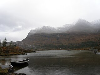
Topsæ is a lake in the municipality of Bygland in Agder county, Norway. The 2.4-square-kilometre (0.93 sq mi) lake is located 3 kilometres (1.9 mi) east of the lake Hovatn, about 10 kilometres (6.2 mi) northeast of the village of Åraksbø. The Topsæfossen waterfall is located at the north end of the lake at the primary inflow. At the southeastern corner of the lake, there is a small dam to regulate the outflow of the lake into the Tovdalselva watershed.

Rosskreppfjorden is a lake in Norway. The 29.51-square-kilometre (11.39 sq mi) lake lies on the border between the municipalities of Valle and Sirdal in Agder county. The lake is part of the Kvina river system and has a hydroelectric power plant in a dam on the south end of the lake. The dam keeps the lake at an elevation of about 929 to 890 metres above sea level.
Longerakvatnet or Longeraksvatnet is a lake in the municipality of Bygland in Agder county, Norway. It has a small dam on the southwest side to regulate the water level for hydro-electric power generation at a plant located down the hill. The lake discharges into the Longeraksåni river which flows into the Byglandsfjorden near the village of Longerak. The 3.4-square-kilometre (1.3 sq mi) lake is located about 6 kilometres (3.7 mi) southeast of the village of Lauvdal and about 10 kilometres (6.2 mi) northeast of the village of Byglandsfjord.
Kolsvatnet is a lake in the municipality of Valle in Agder county, Norway. It is located about 14 kilometres (8.7 mi) southwest of the village of Valle and about 15 kilometres (9.3 mi) northwest of the village of Rysstad. The lake is located south of the lake Botnsvatnet, east of the mountain Urddalsknuten, and northeast of the lake Rosskreppfjorden. The lake has an area of 2.72 square kilometres (1.05 sq mi) and sits at an elevation of 1,034 metres (3,392 ft) above sea level.
Kvifjorden is a lake in Agder county, Norway. THe lake straddles the borders of the municipalities of Bygland, Kvinesdal, and Sirdal. The lake was created when a dam was built along the Kvina river.
Holmavatnet is a lake the Setesdalsheiene mountains of Southern Norway. It is located on the border of the municipalities of Suldal, Vinje, and a small part in Bykle. The southeastern corner of the lake is in Bykle, and it is the northernmost part of all of Aust-Agder county. The lake Skyvatn is located about 5 kilometres (3.1 mi) to the south of the lake.
Høvringsvatnet or Høvringsvatn is a lake in the municipality of Evje og Hornnes in Agder county, Norway. It's located about 10 kilometres (6.2 mi) northeast of the village area of Evje and about 6 kilometres (3.7 mi) southeast of the village area of Byglandsfjord. The lake Homstølvatnet in Froland municipality is located about 5 kilometres (3.1 mi) to the northeast.
Botsvatn or Bossvatn is a lake in the municipality of Bykle in Agder county, Norway. The 14.6-kilometre (9.1 mi) long, narrow reservoir is located just to the southeast of the large lake Blåsjø and northeast of the lake Ytre Storevatnet. The lake holds water for the Brokke Hydroelectric Power Station, located in nearby Valle municipality. The water from the lake can flow out into the nearby river Otra, but only when water is released from the dam.
Gilten is a lake in the municipality of Steinkjer in Trøndelag county, Norway. The 31.62-square-kilometre (12.21 sq mi) lake lies in the northern part of Steinkjer, about 8 kilometres (5.0 mi) northeast of the village of Kvam, about 1.5 kilometres (0.93 mi) north of the village of Følling, and about 14 kilometres (8.7 mi) east of the village of Namdalseid. The lake is only accessible by road from Namdalseid, even though most of the 31.62-square-kilometre (12.21 sq mi) lake lies in Steinkjer. The lake Bangsjøan lies to the northeast and the lake Snåsavatnet lies to the south.
Ytre Storevatnet is a lake in the municipality of Bykle in Agder county, Norway. The 2.8-square-kilometre (1.1 sq mi) lake makes up the northernmost part of the Svartevatnet reservoir that empties into the Sira River system. The lake is located just south of the lake Blåsjø and southwest of Botsvatn. The village of Bykle is about 25 kilometres (16 mi) northeast of the lake.
Havvannet (Norwegian) or Vuolit Áhpelanjávri is a lake in Måsøy Municipality in Troms og Finnmark county, Norway. The 3.69 square kilometres (1.42 sq mi) lake lies isolated in the mountains on the Porsanger Peninsula about 9 kilometres (5.6 mi) northeast of the village of Kokelv in Kvalsund Municipality. The lake sits at an elevation of 293-metre (961 ft) above sea level. The village of Slåtten lies about 14 kilometres (8.7 mi) northwest of the lake.
Harrsjøen is a lake in Rendalen Municipality in Innlandet county, Norway. The 2.31-square-kilometre (0.89 sq mi) lake lies about 3 kilometres (1.9 mi) southwest of the village of Bergset and about 8 kilometres (5.0 mi) northeast of the village of Hanestad. The lake has an outlet in the south through the river Hårenna, a tributary of the river Renaelva.
Mangen is a lake in the municipalities of Eidskog in Innlandet county and Aurskog-Høland in Viken county, Norway. The 4.129-square-kilometre (1.594 sq mi) lake lies about 20 kilometres (12 mi) northeast of the village of Aursmoen and about 20 kilometres (12 mi) west of the village of Skotterud.

Gjesåssjøen is a lake in Åsnes Municipality in Innlandet county, Norway. The 4.06-square-kilometre (1.57 sq mi) lake lies about 5 kilometres (3.1 mi) northwest of the villages of Kjellmyra and Flisa and about 6 kilometres (3.7 mi) northeast of the village of Flisa. The village of Gjesåsen and the Gjesåsen Church lie along the eastern shore of the lake.
The Daaquam River is a river primarily flowing in the administrative region of Chaudière-Appalaches, at South of Quebec in Canada and northern Maine, in United States. The river runs from its source, south of Sainte-Justine, northeast across the Canada–United States border to the Northwest Branch of the Saint John River in Maine.
