Mintonville in Kentucky, USA, is an unincorporated community sitting at the foot of the Green River Knob in the extreme southeastern Casey County. The town was plotted in 1849 and partially built in 1851. The first postmaster, James Wesley, named it after Robert Minton when the post office first opened on October 3, 1851.
Exie is an unincorporated community in Green County, Kentucky, United States. It lies at the intersection of U.S. Route 68 with Kentucky Routes 487 and 745, south of the city of Greensburg, the county seat of Green County. Its elevation is 801 feet (245 m).
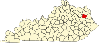
Hazel Green is a census-designated place and unincorporated community in Wolfe County, Kentucky, United States. It lies along Routes 191 and 205 northeast of the city of Campton, the county seat of Wolfe County. Its elevation is 922 feet (281 m). It has a post office with the ZIP code 41332.
Ice is an unincorporated community in Letcher County, Kentucky, United States.
Ulvah is an unincorporated community in Letcher County, Kentucky, United States. Its post office has ceased to exist.
Halfway is an unincorporated community in Allen County, Kentucky, United States.
Tway is an unincorporated community in Harlan County, Kentucky, United States. Its post office is closed.
Fusonia is an unincorporated community and coal town in Perry County, Kentucky, United States.
Hardburly is an unincorporated community and coal town in Perry County, Kentucky, United States.
Christopher is an unincorporated community and coal town in Perry County, Kentucky, United States. Their Post Office has been closed.
Dunham is an unincorporated community and coal town in Letcher County, Kentucky, United States. Dunham's post office operated in the community from 1913 to 1960.
Rosslyn is an unincorporated community in Powell County, Kentucky, United States.
Kildav is an unincorporated community and coal town in Harlan County, Kentucky, United States. Its post office is closed. The name is a combination of Killebrew and Davis, owners of the King Harlan Coal Company.
Edsel is an unincorporated community within Elliott County, Kentucky, United States. Its post office is closed.
Harveyton is an unincorporated community located in Perry County, Kentucky, United States.
Farler is an unincorporated community located in Perry County, Kentucky, United States.
Mills is an unincorporated community located in Knox County, Kentucky, United States.
Helton is an unincorporated community in Leslie County, Kentucky, United States.
Richardson is an unincorporated community in Lawrence County, in the U.S. state of Kentucky.
Royrader is an unincorporated community in Jackson County, in the U.S. state of Kentucky. A post office called Royrader was established in 1927, and remained in operation until 1969. The community derives its name from Roy Rader, a businessperson in the local lumber industry. The community is along Kentucky Route 578 approximately 4 miles south of Annville, Kentucky, the county's largest community.