The Au Sable River is a 138-mile-long (222 km) river in the Lower Peninsula of the U.S. state of Michigan. Rising in the Northern Lower Peninsula, the river flows in a generally southeasterly direction to its mouth at Lake Huron at the communities of Au Sable and Oscoda.It is considered one of the best brown trout fisheries east of the Rockies and has been designated a blue ribbon trout stream by the Michigan Department of Natural Resources. A map from 1795 located in the United States Gazetteer calls it the Beauais River. In French, the river is called the Rivière au sable, literally "Sand River".
The Ozark – St. Francis National Forest is a United States National Forest that is located in the state of Arkansas. It is composed of two separate forests, Ozark National Forest in the Ozark Mountains; and St. Francis National Forest on Crowley's Ridge. Each forest has distinct biological, topographical, and geological differences.
The Spring Mountains National Recreation Area (SMNRA) is a U.S. national recreation area, administered by the U.S. Forest Service, west of Las Vegas, Nevada. It covers over 316,000 acres. The area runs from low meadows, to the 11,918-foot (3,633 m) Mount Charleston. The SMNRA is a part of the Humboldt-Toiyabe National Forest. It adjoins the Red Rock Canyon National Conservation Area, which is administered by the Bureau of Land Management.
Pinnacle Mountain State Park is a 2,356-acre state park located in Pulaski County, Arkansas just outside of Little Rock. The main attraction is Pinnacle Mountain, an iconic landmark surrounded by the bottomlands of the Big Maumelle and Little Maumelle rivers.
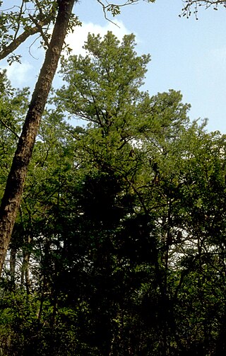
Sugarloaf Mountain is the fifth-highest named point and the most prominent point in the U.S. state of Florida. At 312 feet above sea level it is also the highest point on the geographic Florida Peninsula. The hill is in Lake County, near the town of Clermont.
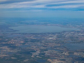
Lake Apopka is the fourth largest lake in the U.S. state of Florida. It is located 15 miles (24 km) northwest of Orlando, mostly within the bounds of Orange County, although the western part is in Lake County. Fed by a natural spring, rainfall and stormwater runoff, water from Lake Apopka flows through the Apopka-Beauclair Canal and into Lakes Beauclair and Dora. From Lake Dora, water flows into Lake Eustis, then into Lake Griffin and then northward into the Ocklawaha River, which flows into the St. Johns River. Multiple parks or nature trails are present around the lake including Magnolia Park, Lake Apopka Wildlife Drive, Ferndale Preserve, Oakland Nature Preserve, Dr. Bradford Memorial Park, and Newton Park, named for A. B. Newton.

The Sam Houston National Forest, one of four National Forests in Texas, is located 50 miles north of Houston. The forest is administered together with the other three United States National Forests and two National Grasslands located entirely in Texas, from common offices in Lufkin, Texas. The units include Angelina, Davy Crockett, Sabine, and Sam Houston National Forests, plus Caddo National Grassland and Lyndon B. Johnson National Grassland. There are local ranger district offices located in New Waverly. It is located in portions of three Texas counties including Montgomery, San Jacinto, and Walker.

The Lariat Loop National Scenic and Historic Byway is a National Scenic Byway and a Colorado Scenic and Historic Byway located in Jefferson County, Colorado, USA. The byway is a 40-mile (64 km) loop in the Front Range foothills west of Denver through Golden, Lookout Mountain Park, Genesee Park, Evergreen, Morrison, Red Rocks Park, and Dinosaur Ridge. The Lariat Loop connects to the Mount Blue Sky Scenic Byway at Bergen Park.

The Uinta Highline Trail is a trail in the Uinta Mountains of Utah that traverses the range 104 miles (167 km) from east to west. The trail passes through expansive alpine landscapes dominated by metasedimentary rocks sculpted by past glaciers. The broad glacial basins are dotted by hundreds of lakes.
Mountain Lake Wilderness is a U.S. Wilderness Area in the George Washington and Jefferson National Forests. The wilderness area is located next to privately owned Mountain Lake, and consists of 8,314 acres (3,365 ha) in Virginia and 2,721 acres (1,101 ha) in West Virginia.

Wild Rivers Recreation Area is located in north central New Mexico within the Rio Grande del Norte National Monument. Two rivers that run through the park, the Rio Grande and Red River are National Wild and Scenic Rivers. NM 378 that traverses the recreation area is designated a New Mexico Scenic Byway. Recreational opportunities include whitewater rafting, hiking, biking, fishing and camping.

Todd Lake is a natural lake near the crest of the Cascade Range in central Oregon in the United States. The lake covers 45 acres (18 ha). It is named in honor of John Y. Todd, an early settler in Central Oregon. Today, the lake and surrounding forest is managed by the U.S. Forest Service as part of the Deschutes National Forest. The Oregon Department of Fish and Wildlife regularly stocks the lake with brook trout. There is a day-use area and a rustic campground located on the west shore. In the summer, the lake is a popular outdoor recreation site for picnicking, fishing, hiking, and nature viewing. In the winter, trails in the area are used for cross-country skiing and snowshoeing.
Magnolia Park is a county park located on the eastern shore of Lake Apopka. It is managed by the Orange County Parks and Recreation.
The Lake Apopka Loop Trail is a trail running along Lake Apopka North Shore, connecting Magnolia Park and the Green Mountain Scenic Overlook and Trailhead. It is managed by the St. Johns River Water Management District.

Vatia is a village on Tutuila Island in American Samoa. It is a north shore village located on Vatia Bay. The road to Vatia, American Samoa Highway 006, is the only road going through National Park of American Samoa. Vatia is a scenic community at the foot of Pola Ridge and surrounded by the national park. It is only reached by Route 6 which traverses the national park before reaching Vatia. There was once a hiking trail over Maugaloa Ridge from Leloaloa, but since the completion of Route 6, this trail is now overgrown. It is home to a beach, and panoramic views of jungle-covered peaks surround the village on all sides. Vatia is the center of the Tutuila-section of National Park of American Samoa. It is located in Vaifanua County.
Minnesota Scenic Byways are a system of roads in the U.S. state of Minnesota which pass through areas of scenic, cultural, or recreational significance. There are currently 22 scenic byways in the system with a total length of 2,948 miles (4,744 km). Eight of these byways are also designated as National Scenic Byways, and the North Shore Scenic Drive is further designated as an All-American Road.
The Tavares and Gulf Railroad (T&G) was a historic railroad in Central Florida that operated for many years as a subsidiary of the Seaboard Air Line Railroad. It existed from 1886 to 1969.