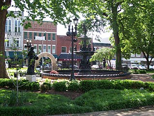
Morgantown is a home rule-class city in, and the seat of Butler County, Kentucky, United States. The population was 2,471 at the time of the 2020 Census.

Bowling Green is a home rule-class city and the county seat of Warren County, Kentucky, United States. Founded by pioneers in 1798, Bowling Green was the provisional capital of Confederate Kentucky during the American Civil War. As of the 2020 census, its population of 72,294 made it the third-most-populous city in the state after Louisville and Lexington; its metropolitan area, which is the fourth largest in the state after Louisville, Lexington, and Northern Kentucky, had an estimated population of 179,240; and the combined statistical area it shares with Glasgow has an estimated population of 233,560.

William Huston Natcher was a Democratic congressman, serving in the United States House of Representatives from 1953 until his death from heart failure in Bethesda, Maryland in 1994. He is the second longest-serving member ever of the United States House of Representatives from the Commonwealth of Kentucky.

U.S. Route 68 is a United States highway that runs for 560 miles (900 km) from northwest Ohio to Western Kentucky. The highway's western terminus is at US 62 in Reidland, Kentucky. Its present northern terminus is at Interstate 75 in Findlay, Ohio, though the route once extended as far north as Toledo. US 68 intersects with US 62 three times during its route.

U.S. Route 231 (US 231) is a north-south U.S highway that is a parallel route of US 31. It runs for 912 miles (1,468 km) from St. John, Indiana, at US 41 to south of US 98 in downtown Panama City, Florida. One of its most notable landmarks is the William H. Natcher Bridge, a 0.853 miles (1.373 km) long cable-stayed bridge that connects Rockport, Indiana, to Owensboro, Kentucky, spanning the Ohio River.

Kentucky Route 80 (KY 80) is a 483.55-mile-long (778.20 km) state highway in the southern part of the U.S. state of Kentucky. The route originates on the state's western border at Columbus in Hickman County and stretches across the southern portion of the state, terminating southeast of Elkhorn City on the Virginia state line. It is the longest Kentucky State Highway, though the official distance as listed in route logs is much less due to multiple concurrencies with U.S. Route 68 (US 68) and US 23.

The William H. Natcher Green River Parkway was the designation for a 72.3-mile-long (116.4 km) freeway that ran from Bowling Green to Owensboro in the US commonwealth of Kentucky. The Natcher Parkway was one of nine highways that were a part of Kentucky's parkway system. The portion north of Interstate 65 (I-65) was signed as I-165, and the portion south of I-65 as Kentucky Route 9007 on March 6, 2019.

U.S. Route 31W is the westernmost of two parallel routes for U.S. Route 31 from Nashville, Tennessee to Louisville, Kentucky.

Kentucky Route 70 (KY 70) is a long east-east state highway that originates at a junction with U.S. Route 60 (US 60) in Smithland in Livingston County, just east of the Ohio River. The route continues through the counties of Crittenden, Caldwell, Hopkins, Muhlenberg, Butler, Edmonson, Barren, Barren, Metcalfe, Green, Taylor, Casey, Pulaski, Lincoln and back into Pulaski again to terminate at a junction with US 150 near Maretburg in Rockcastle.

Interstate 65 (I-65) enters the US state of Kentucky from Tennessee, five miles (8.0 km) south of Franklin. It passes by the major cities of Bowling Green, Elizabethtown, and Louisville before exiting the state into Indiana.
Neatsville is an unincorporated community in Adair County, in the U.S. state of Kentucky. It is located at the junction of Kentucky Route 206 and Kentucky Route 76. Its elevation is 705 feet (215 m). For unknown reasons, the town's name was spelled as Neetsville from 1876 until 1886, when the town's post office closed. In its early history from around the 1810s to 1900, Neatsville progressively grew to become a well-established, incorporated town. It has been relocated twice through the years, once due to flooding circa 1900–1902, which decimated the town, and once in the 1960s when the Green River was impounded to make way for the Green River Reservoir.

U.S. Route 231 in Kentucky runs 86.465 miles (139.152 km) from the Tennessee state line near Adolphus to the William H. Natcher Bridge on the Ohio River near Rockport, Indiana. It crosses the state mainly in the west-central region, traversing Allen, Warren, Butler, Ohio, and Daviess Counties.

Interstate 165 (I-165) is a 70.2-mile-long (113.0 km) auxiliary Interstate Highway in the US state of Kentucky. A spur route of I-65, it extends from I-65 in Bowling Green to U.S. Route 60 (US 60) and US 231 in Owensboro. It opened in 1972 as the Green River Parkway and was renamed the William H. Natcher Parkway in 1994. It was designated as I-165 in 2019 after completion of a project that brought the highway up to Interstate Highway standards.


