Rainsborough Camp is an Iron Age hillfort in West Northamptonshire, England, between the villages of Croughton, Aynho, and Charlton.

Mamucium, also known as Mancunium, is a former Roman fort in the Castlefield area of Manchester in North West England. The castrum, which was founded c. AD 79 within the Roman province of Roman Britain, was garrisoned by a cohort of Roman auxiliaries near two major Roman roads running through the area. Several sizeable civilian settlements containing soldiers' families, merchants and industry developed outside the fort. The area is a protected Scheduled Ancient Monument.

Dolebury Warren is a 90.6 hectares biological Site of Special Scientific Interest (SSSI) and ancient monument near the villages of Churchill and Rowberrow in North Somerset, part of South West England. It is owned by the National Trust, who acquired the freehold in 1983, and managed by the Avon Wildlife Trust.

Ditchling Beacon is the highest point in East Sussex, England, with an elevation of 248 m (814 ft). It is south of Ditchling and to the north-east of Brighton. It is a large chalk hill with a particularly steep northern face, covered with open grassland and sheep-grazing areas. It is the third-highest point on the South Downs, behind Butser Hill and Crown Tegleaze.
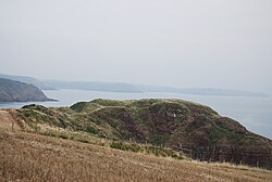
Embury Beacon is the site of an Iron Age promontory fort on the west of the Hartland Peninsula, north of Bude and west of Clovelly, in north Devon. The fort has almost entirely been lost to coastal erosion, but a fraction of the eastern ramparts still exist at approximately 150 metres (490 ft) above Sea Level. It is part of the National Trust property of Bideford Bay and Hartland, which also includes two other hill forts at Windbury Head and Bucks Mills earthworks. The site's name suggests it was the location of a beacon, possibly during the Elizabethan period, but there is no archaeological evidence of this.
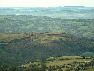
Nordy Bank is an Iron Age hill fort on Brown Clee Hill in the Shropshire Hills Area of Outstanding Natural Beauty in South Shropshire, England.

Moel y Gaer, also known as Moel-y-Gaer Camp or Moel y Gaer Hillfort, is an Iron Age hillfort located on a western spur of the Clwydian Range, near the village of Llanbedr, Denbighshire, Wales. The site is a scheduled monument, classified as a prehistoric defensive hillfort.

Scratchbury Camp is the site of an Iron Age univallate hillfort on Scratchbury Hill, overlooking the Wylye valley about 1 km northeast of the village of Norton Bavant in Wiltshire, England. The fort covers an area of 37 acres (15 ha) and occupies the summit of the hill on the edge of Salisbury Plain, with its four-sided shape largely following the natural contours of the hill.

Cholesbury Camp is a large and well-preserved Iron Age hill fort on the northern edge of the village of Cholesbury in Buckinghamshire, England. It is roughly oval-shaped and covers an area, including ramparts, of 15 acres (6.1 ha), and measures approximately 310 m (1,020 ft) north-east to south-west by 230 m (750 ft) north-west to south-east. The interior is a fairly level plateau which has been in agricultural use since the medieval period. The hill fort is now a scheduled ancient monument.

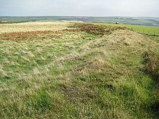
Bratton Castle is a bivallate Iron Age built hill fort on Bratton Down, at the western edge of the Salisbury Plain escarpment. The hill fort comprises two circuits of ditch and bank which together enclose a pentagonal area of 9.3 hectares.

The Giant's Castle is a promontory fort of the Iron Age, on St Mary's, Isles of Scilly, England. It is a scheduled monument.

Kelsey Head is a coastal Site of Special Scientific Interest (SSSI) and headland in north Cornwall, England, UK, noted for its biological interest. The site contains an Iron Age hill fort.

Dinedor Camp is an Iron Age hillfort, about 1 kilometre (0.6 mi) west of the village of Dinedor and about 3 kilometres (1.9 mi) south of Hereford in England. It is a scheduled monument.

Cornish promontory forts, commonly known in Cornwall as cliff castles, are coastal equivalents of the hill forts and Cornish "rounds" found on Cornish hilltops and slopes. Similar coastal forts are found on the north–west European seaboard, in Normandy, Brittany and around the coastlines of the British Isles, especially in Wales, Scotland and Ireland. Many are known in southwest England, particularly in Cornwall and its neighbouring county, Devon. Two have been identified immediately west of Cornwall, in the Isles of Scilly.

Bigbury Camp is a univallate hill fort in the parish of Harbledown and Rough Common in Kent in England. The fort is a Scheduled Ancient Monument, with a list entry identification number of 1005169. Bigbury Camp is the only confirmed Iron Age hill fort in east Kent. It is managed by Kent Wildlife Trust.

Caesar's Camp is an Iron Age hill fort straddling the border of the counties of Surrey and Hampshire in southern England. The fort straddles the borough of Waverley in Surrey and the borough of Rushmoor and the district of Hart, both in Hampshire. Caesar's Camp is a Scheduled Ancient Monument with a list entry identification number of 1007895. It lies approximately 3 kilometres (1.9 mi) north of the town of Farnham, and a similar distance west of Aldershot. The hillfort lies entirely within the Bourley and Long Valley Site of Special Scientific Interest. Caesar's Camp is a multivallate hillfort, a fort with multiple defensive rings, occupying an irregular promontory, with an entrance on the south side. The site has been much disturbed by military activity, especially at the southeast corner. The remains of the hillfort are considered to be of national importance.

The Bulwarks, Porthkerry is a promontory fort in Rhoose, Vale of Glamorgan, on the southern coast of Wales overlooking the Bristol Channel. It probably dates to the Iron Age and continued to be occupied during the Roman period in Britain. The ramparts and ditches along the west side are well preserved, but the fortifications are heavily overgrown.
Holkham Camp, or Holkham Fort, is an Iron Age fort in Norfolk, England, about 1 mile (1.6 km) north-west of the village of Holkham. It is a scheduled monument.

Banbury Hillfort, or Banbury Hill Camp, is an Iron Age hillfort, about 1.25 miles (2.0 km) south of Sturminster Newton and 1 mile (1.6 km) north-west of the village of Okeford Fitzpaine in Dorset, England.
South Weald Camp was a hillfort based in South Weald, Brentwood, Essex, England. Roughly circular in plan, the fort covered 2.8 hectares, with a suggested construction date in the late Iron Age, from the 1st century BC to the 1st century AD. The location is associated in this period with the Catuvellauni and the Trinovantes.