
Milwaukee County is located in the U.S. state of Wisconsin. At the 2020 census, the population was 939,489, down from 947,735 in 2010. It is both the most populous and most densely populated county in Wisconsin, and the 45th most populous county nationwide; Milwaukee, its eponymous county seat, is also the most populous city in the state. The county was created in 1834 as part of Michigan Territory and organized the following year.

Greendale is a village in Milwaukee County, Wisconsin, United States. The population was 14,854 at the 2020 census. Greendale is located southwest of Milwaukee, Wisconsin, and is a part of the Milwaukee metropolitan area. A planned community, it was established by the United States government during the Great Depression.
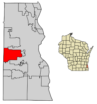
West Allis is a city in Milwaukee County, Wisconsin, United States. A suburb of Milwaukee, it is part of the Milwaukee metropolitan area. The population was 60,325 at the 2020 census.

New Berlin is a city located in eastern Waukesha County in the U.S. state of Wisconsin. The population was 40,451 at the 2020 census, making it the third-largest community in Waukesha County after the cities of Waukesha and Brookfield.

Schenley Park is a large municipal park in Pittsburgh, Pennsylvania. It is located between the neighborhoods of Oakland, Greenfield, and Squirrel Hill. It is also listed on the National Register of Historic Places as a historic district. In 2011, the park was named one of "America's Coolest City Parks" by Travel + Leisure.
The Milwaukee metropolitan area is a major metropolitan area located in Southeastern Wisconsin, consisting of the city of Milwaukee and the surrounding area. There are several definitions of the area, including the Milwaukee–Waukesha–West Allis metropolitan area and the Milwaukee–Racine–Waukesha combined statistical area. It is the largest metropolitan area in Wisconsin, and the 39th largest metropolitan area in the United States.

The Wisconsin State Fair is an annual event held at the Wisconsin State Fair Park in West Allis, Wisconsin, a suburb of Milwaukee. The modern fair takes place in August and lasts 11 days.

The Wisconsin State Fair Park is a fairgrounds and exhibition center in West Allis, Wisconsin, a suburb west of Milwaukee. It has been the location of the Wisconsin State Fair since 1892. The fairgrounds are open year-round, hosting various expeditions.

Wisconsin Lutheran College (WLC) is a private liberal arts college affiliated with the Wisconsin Evangelical Lutheran Synod and located on the border of Milwaukee and Wauwatosa, Wisconsin. It has an enrollment of about 1,200 students and is accredited by the Higher Learning Commission.
Brown Deer Park Golf Course is a public golf course maintained as part of the Milwaukee County Park System. The course was designed in 1929 by George Hanson. Since then, the course has been partially redesigned, the clubhouse has become a historic site and the course was the fourth and final course to host the U.S. Bank Championship in Milwaukee, a PGA Tour event that was held from 1968 to 2009. Located on the northwest side of the city of Milwaukee, the course is surrounded by trees and features deep rough. Many famous golfers have played tournaments at the southeastern Wisconsin course. Jack Nicklaus, Greg Norman, Lee Trevino, and Ed Sneed have all competed here at some point in their careers. In 1996, Tiger Woods made his pro debut at the course when he played in the Greater Milwaukee Open. Despite making a hole-in-one on the 14th hole, he finished tied for 60th and took home $2,544 in earnings. Although the course no longer hosts a PGA Tour event, it remains the premiere course in the Milwaukee County Park System.
Peninsula State Park is a 3,776-acre (1,528 ha) Wisconsin state park with eight miles (13 km) of Green Bay shoreline in Door County. Peninsula is the third largest state park in Wisconsin and is visited by an estimated one million visitors annually.
Alexander Chadbourne Eschweiler was an American architect with a practice in Milwaukee, Wisconsin. He designed both residences and commercial structures. His eye-catching Japonist pagoda design for filling stations for Wadham's Oil and Grease Company of Milwaukee were repeated over a hundred times, though only a very few survive. His substantial turn-of-the-20th-century residences for the Milwaukee business elite, in conservative Jacobethan or neo-Georgian idioms, have preserved their cachet in the city.

Lakeshore State Park is a 22-acre (8.9 ha) Wisconsin state park located on the shores of Lake Michigan in the city of Milwaukee. It is situated adjacent to both Discovery World and Henry Maier Festival Park. It is the only urban state park in Wisconsin and features restored prairie and a pebble beach. In addition to the prairie, portions of the park are planted with Kentucky bluegrass.

Three Harbors Council is a local council of the Boy Scouts of America serving three southeastern Wisconsin counties: Milwaukee County, Racine County, and Kenosha County. Its name and logo refer to the three major port cities of Milwaukee, Racine, and Kenosha on Lake Michigan.

Lake Park, a mile-long park on a bluff above Lake Michigan in Milwaukee, Wisconsin, is an urban park covering 138.1-acre (559,000 m2).
Kirchhoff & Rose was an architectural firm in Milwaukee, Wisconsin. The partnership began in 1894 between Charles Kirchhoff Jr. and Thomas Leslie Rose.

Riverside Regional Park is located on the near west side of Indianapolis, Indiana, and is bounded by 38th Street to the north, 18th Street to the south, Riverside Drive to the east, and Cold Spring Road to the west.
Estabrook Park is a Milwaukee County park in the village of Shorewood, Wisconsin and is home to the 1,081 ft (329 m) WITI TV Tower and the historic Benjamin Church House. It was named for Charles E. Estabrook, a distinguished Wisconsin lawyer and politician, and is located on a nearly 125 acre, strip of land between the Milwaukee River and the former Chicago and Northwestern Railroad, now converted into part of the Oak Leaf Trail.

Washington Park (1900) originally called West Park is a park in Milwaukee, Wisconsin, in the United States. From 1892–1958 the park was home to the Milwaukee County Zoo. It is one of the oldest parks in Milwaukee and it was added to the Wisconsin Architecture and History Inventory in 2019.

Dretzka Park is a 327 acres (132 ha) acre park on the north side of Milwaukee, Wisconsin in the United States. The park was named for Polish immigrant Jerome C. Dretzka who served on the Milwaukee County Park System Commission for 43 years.
