
Solanco School District is a large, rural public school district located in the southern end of Lancaster County, Pennsylvania. Solanco School District encompasses approximately 180 square miles (470 km2). Solanco School District serves: Providence Township, Eden Township, Quarryville Borough, Little Britain Township, Bart Township, Colerain Township, Drumore Township, East Drumore Township and Fulton Township. According to 2008 local census data, it served a resident population of 30,566. By 2010, the district's population increased to 31,871 people. In 2009, the district residents’ per capita income was $17,040, while the median family income was $49,432. In the Commonwealth, the median family income was $49,501 and the United States median family income was $49,445, in 2010.
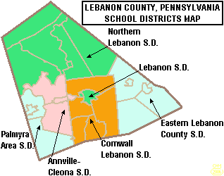
The Palmyra Area School District is the public school system in southwest Lebanon County, Pennsylvania.

The Boyertown Area School District is a large public school district which covers portions of Berks and Montgomery Counties in southeastern Pennsylvania. When the Boyertown Area School District was formed in 1953 it was one of the largest in the state, encompassing 100 square miles (260 km2). In Berks County it covers the Boroughs of Bally, Bechtelsville and Boyertown and Colebrookdale Township, Douglass Township, Earl Township and Washington Township. In Montgomery County it covers Douglass Township, New Hanover Township and Upper Frederick Township.

The Brockway Area School District is a small, rural public school district located in north west Pennsylvania, US. The District encompasses approximately 147 square miles (380 km2) spanning portions of two counties. In Elk County it covers a small portion of Horton Township. In Jefferson County it covers the Borough of Brockway and Polk Township, Snyder Township and Washington Township. The district operates one elementary school and Brockway Area Junior/Senior High School. The district is with the Riverview Intermediate Unit 6 region. The Intermediate Unit provides support services and therapy to special education students. It also provides training to school personnel.
The Canton Area School District is a diminutive, rural, Pennsylvania public school district that encompasses approximately 204 square miles (530 km2). Canton Area School District is split over three counties. In Bradford County, it serves Canton Township including Canton Borough; while excluding the borough of Alba, and Leroy Township. In Lycoming County, the district serves McIntyre Township including the villages of Marsh Hill and Ralston; and McNett Township including the villages of Chemung, Ellenton, Leolyn, Penbryn, and Roaring Branch. In Tioga County, the district serves Union Township. According to 2000 local census data, the district serves a resident population of 6,213. By 2010, the district's population increased to 6,534 people. The educational attainment levels for the Canton Area School District population were 86.6% high school graduates and 10.9% college graduates. The district is one of the 500 public school districts of Pennsylvania.

The Bald Eagle Area School District is a midsized, suburban/rural public school district located in Centre County, Pennsylvania. The district serves the Boroughs of Howard, Milesburg, Port Matilda, Snow Shoe and Unionville and Boggs Township, Burnside Township, Howard Township, Huston Township, Snow Shoe Township, Union Township and Worth Township in Centre County, Pennsylvania. Bald Eagle Area School District encompasses approximately 345 square miles (890 km2). According to 2000 federal census data, it serves a resident population of 12,882. By 2010, the district's population increased to 13,218.

The Clarion Area School District is a small, rural public school district which covers the Borough of Clarion, Highland Township, and Paint Township as well as most of Monroe Township in Clarion County, Pennsylvania. It encompasses approximately 71 square miles (180 km2). According to 2000 federal census data, it serves a resident population of 10,183. By 2010, the district's population declined to 8,978 people. In 2009, the district residents' per capita income was $14,302, while the median family income was $43,665. In the Commonwealth, the median family income was $49,501 and the United States median family income was $49,445, in 2010. By 2013, the median household income in the United States rose to $52,100.
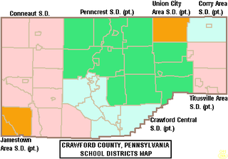
The Crawford Central School District is a midsized, public school district in Crawford County, Pennsylvania. It serves the City of Meadville, Borough of Cochranton and East Fairfield Township, Fairfield Township, Union Township, Vernon Township, Wayne Township and West Mead Township as well as a small portion of Greenwood Township in Crawford County, Pennsylvania, as well as French Creek Township in neighboring Mercer County, Pennsylvania. Crawford Central School District encompasses approximately 156 square miles. According to 2000 federal census data, it serves a resident population of 30,882 people. By 2010, the district's population declined to 30,635 people. In 2009, the Crawford Central School District residents' per capita income was $18,463, while the median family income was $43,771. In the Commonwealth, the median family income was $49,501 and the United States median family income was $49,445, in 2010. By 2013, the median household income in the United States rose to $52,100.

The Elwood City Area School District (ECASD) is a diminutive, suburban, public school district located in Beaver County, Pennsylvania and Lawrence County, Pennsylvania. It serves the boroughs of Ellwood City, Ellport, and New Beaver, and the townships of Wayne, and Perry Townships. Elwood City Area School District encompasses approximately 49 square miles (130 km2). According to 2000 federal census data, it served a resident population of 14,040. In 2010 the district's population risen to 14,341 people. In 2009, the district residents’ per capita income was $16,554, while the median family income was $42,326. In the Commonwealth, the median family income was $49,501 and the United States median family income was $49,445, in 2010.
Union Area School District is a diminutive, suburban public school district located in Lawrence County, Pennsylvania. The Union Area School District encompasses approximately 10 square miles (26 km2). The District serves Union Township, Lawrence County, Pennsylvania as well the southeastern portion of Mahoning Township and the independent district of Edinburg which encompasses portions of several neighbouring townships. According to 2000 federal census data, Union Area School District served a resident population of 5,103. In 2010, the population was 5,563 people. In 2009, the district residents’ per capita income was $16,148, while the median family income was $41,086. In the Commonwealth, the median family income was $49,501 and the United States median family income was $49,445, in 2010.

The Commodore Perry School District is a diminutive, rural public school district serving parts of Mercer County, Pennsylvania. The district encompasses the communities of Sheakleyville, Deer Creek Township, Sandy Creek Township, Salem Township, Otter Creek Township, and Perry Township. Commodore Perry School District encompasses approximately 74 square miles (190 km2). According to 2000 federal census data, it served a resident population of 4,328. By 2010, the District's population was 4,232 people. In 2009 the Commodore Perry School District residents' per capita income was $16,448, while the median family income was $40,453.
The Grove City Area School District is a small, rural, public school district serving the south eastern region of Mercer County, Pennsylvania. It encompasses the communities of Grove City, Pine Township, Wolf Creek Township, Springfield Township, and Liberty Township. Grove City Area School District encompasses approximately 92 square miles (240 km2). According to 2000 federal census data, it served a resident population of 16,494. By 2010, the district's population was 17,687 people. In 2009, the District residents' per capita income was $17,309, while median family income was $45,646 a year.
The Reynolds School District is a rural, public school district serving parts of Mercer County, Pennsylvania. Reynolds School District encompasses approximately 88 square miles (230 km2) encompassing the communities of Fredonia, West Salem Township, Delaware Township, and Pymatuning Township. The western border of the district is part of the Pennsylvania - Ohio border. According to 2000 federal census data, it served a resident population of 10,158. By 2010, the district's population declined to 9,611 people. It is built on what was once a military camp during World War II, Camp Reynolds. In 2009, the district residents' per capita income was $16,380 while the median family income was $42,200. In the Commonwealth, the median family income was $49,501 and the United States median family income was $49,445, in 2010.
The Jamestown Area School District is a small, rural, public school district serving parts of Mercer County, Pennsylvania and Crawford County, Pennsylvania. It encompasses 61 square miles (160 km2) including the communities of Jamestown and Greene Township in Mercer County, and the municipalities of West Shenango Township and South Shenango Township in Crawford County.
The West Middlesex Area School District is a small, rural public school district serving the southwestern portion of Mercer County, Pennsylvania. It encompasses the communities of West Middlesex, Shenango Township, and Lackawannock Township. The West Middlesex Area School District encompasses approximately 52 square miles (130 km2). The district operates on a single 40-acre campus. According to 2000 federal census data, it served a resident population of 7,527. By 2010, the district's population declined to 7,454 people. In 2009, the district residents’ per capita income was $16,870, while the median family income was $40,558. In the Commonwealth, the median family income was $49,501 and the United States median family income was $49,445, in 2010.
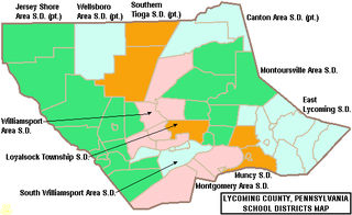
The South Williamsport Area School District is a small public school district in Lycoming County, Pennsylvania, in the United States. The school serves several suburbs of Williamsport, including South Williamsport, DuBoistown, Susquehanna Township, and Armstrong Township. The district encompasses approximately 36 square miles (93 km2). According to 2000 federal census data, it served a resident population of 9,400. By 2010, the district's population declined to 9,268 people. In 2009, the district residents’ per capita income was $18,650, while the median family income was $41,002. In the Commonwealth, the median family income was $49,501 and the United States median family income was $49,445, in 2010. By 2013, the median household income in the United States rose to $52,100.

The Northern Potter School District is a rural public school district located in northeastern Potter County, Pennsylvania. It serves the municipalities of Ulysses, Ulysses Township, Genesee Township, Bingham Township, and Harrison Township. Portions of Allegany Township and Hector Township are also within its boundaries. Northern Potter School District encompasses approximately 231 square miles (600 km2). According to 2010 federal census data, it serves a resident population of 4,113, making it a district of the fourth class. The educational attainment levels for the School District population were 84% high school graduates and 8.2% college graduates. The district is one of the 500 public school districts of Pennsylvania.
The Galeton Area School District is a diminutive, rural public school district operating in Potter County and Tioga County in Pennsylvania. Galeton Area School District encompasses approximately 325 square miles (840 km2). It serves the municipalities of Galeton, Abbott Township, West Branch Township, Pike Township, and a portion of Hector Township in Potter County, plus Elk Township and Gaines Township in Tioga County, Pennsylvania. According to 2000 federal census data, the district served a resident population of 3,292. By 2010, the district's population declined to 2,929 people. The educational attainment levels for the Galeton Area School District population were 82.7% high school graduates and 9.6% college graduates.

The Montrose Area School District is a small, rural public school district that is located in northwestern Susquehanna County, Pennsylvania. It serves the following municipalities: Montrose, Bridgewater Township, Franklin Township, Liberty Township, Jessup Township, Forest Lake Township, Silver Lake Township, Little Meadows, Choconut Township, Friendsville, and Middletown Township.

The Northern Tioga School District is a rural public school district operating in Tioga County, Pennsylvania, US. The district serves an extensive rural region, spanning 335 square miles (870 km2) across the northern section of Tioga County. Northern Tioga School District is a third class school district having less than 30,000 residents and is one of the 500 public school districts of Pennsylvania. Municipalities served include: Tioga, Tioga Township, Jackson Township, Lawrenceville, Lawrence Township, Farmington Township, Elkland, Osceola Township, Knoxville, Chatham Township, Deerfield Township, Brookfield, Westfield, and Clymer Township. According to 2000 federal census data, it served a resident population of 14,670. By 2010, the district's population declined to 14,523 people. The educational attainment levels for the Northern Tioga School District population were 85.6% high school graduates and 11.7% college graduates.

