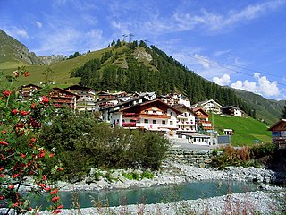
Samnaun is a high Alpine village and a valley at the eastern end of Switzerland and a municipality in the Engiadina Bassa/Val Müstair Region in the Swiss canton of Graubünden.

The Muttler is the highest mountain in the Samnaun Alps. It is located south of Samnaun in the Swiss canton of Graubünden. From 1972 - 2011 a transmitter was located west of the summit.

Piz Rots is a mountain of the Samnaun Alps, located on the Austria–Switzerland border. It lies south-west of Samnaun.

Bürkelkopf is a mountain of the Samnaun Alps, located on the border between Austria and Switzerland. It lies between Ischgl (Tyrol) and Samnaun (Graubünden). In winter it is part of a ski area.
The Grübelekopf is a mountain of the Samnaun Alps, located on the border between Austria and Switzerland.

Piz Mundin is a mountain of the Samnaun Alps, located between Samnaun and Martina in the Swiss canton of Graubünden. With an elevation of 3,146 metres above sea level, Piz Mundin is one of the highest summits in the Samnaun Alps.

Piz Tschütta is a mountain of the Samnaun Alps, overlooking Samnaun in the canton of Graubünden. With an elevation of 3,254 metres (10,676 ft) above sea level, it is the second highest mountain of the Samnaun Alps.

Kirchlespitz is a mountain in Liechtenstein in the Rätikon range of the Eastern Alps between Malbun and Steg, with a height of 1,929 metres (6,329 ft).

Galinakopf is a mountain on the border of Austria and Liechtenstein in the Rätikon range of the Eastern Alps, with a height of 2,198 metres (7,211 ft).

Garsellakopf is a mountain on the border of Liechtenstein and Austria in the Rätikon range of the Eastern Alps to the east of the town of Schaan, with a height of 2,105 metres (6,906 ft).

The Western Rhaetian Alps are a mountain range in the central part of the Alps.

The Vesulspitze is a mountain of the Samnaun Alps, located near Ischgl in Austria. With an elevation of 3,089 metres above sea level, it is the highest summit of the Samnaun Alps north of the Zeblasjoch.

The Fimbatal, also Fimbertal, is an alpine valley situated between the Silvretta Alps and the Samnaun Alps. The valley is drained by the Fimbabach river, a tributary of the Inn basin (Trisanna) at Ischgl. The highest mountain bordering the Fimbatal is the Fluchthorn.

The Heidelberger Hut is a mountain hut located in the Silvretta in the Swiss canton of Graubünden. It lies at an altitude of 2,264 metres above sea level in the Val Fenga.
The Val Sinestra is a valley of the Swiss Alps, located in the Engadin between the Silvretta and the Samnaun ranges. The valley is drained by La Brancla, a tributary of the Inn basin, near Ramosch. The highest mountains in the Val Sinestra are the Muttler, Piz Tschütta and Piz Tasna. The valley is approximately 10 kilometres long.
Piz Malmurainza is a mountain of the Swiss Samnaun Alps, located north of Tschlin in the canton of Graubünden. It lies between the Muttler and Piz Mundin, on the range separating the main Inn valley from the Samnaun valley.
The Palinkopf is a mountain of the Samnaun Alps, located on the border between Switzerland and Austria. It lies west of Samnaun and is part of the Samnaun-Ischgl ski area.

Flimspitz is a mountain of the Samnaun Alps, located on the border between Switzerland and Austria. It lies on the range between the Greitspitz and the Bürkelkopf.

Kompass Karten is an Austrian map publisher based in Innsbruck, which specialises in hiking maps, and guides, digital maps, and cycling maps and guides. Its range has over 1,000 titles.


