Grey Street, Melbourne

Last updated

Grey St, St Kilda, looking south-west from the corner of Dalgety St Grey Street, Melbourne.jpeg
Grey St, St Kilda, looking south-west from the corner of Dalgety St

There are 14 Grey Streets in metropolitan Melbourne, but by far the best-known is Grey Street in St Kilda, once a grand residential street but now with a reputation as a centre of prostitution.

Contents

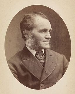
Grey St was almost certainly named after Sir George Grey, who was Governor of South Australia from 1841 to 1845 and later Prime Minister of New Zealand from 1877 to 1879. St Kilda's official historian, John Butler Cooper, suggests that it may have been named for another Sir George Grey, a British politician, but the fact other nearby streets are also named after colonial governors (Fitzroy St after Charles FitzRoy, Governor of New South Wales, Barkly St after Henry Barkly, Governor of Victoria, and Robe St after Frederick Robe, Grey's successor as Governor of South Australia), makes the first Sir George Grey more likely. [1]

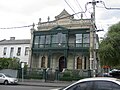
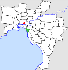
Grey Street runs south-east between Fitzroy and Barkly Streets. It lies within the original settlement area of the village of St Kilda, which was subdivided for land sales in 1842. As St Kilda grew into a wealthy and fashionable suburb during the second half of the 19th century, Grey St became lined with the mansions of Melbourne's prosperous mercantile class, attracted by the proximity of St Kilda beach and the hotels and restaurants of Fitzroy St and The Esplanade. One of leading hotels of the era, the George, stands on the corner of Fitzroy and Grey Sts. After decades of decline, it has recently been refurbished and its upper floors converted to apartments.

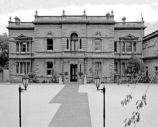
The best-known of Grey Street's great homes was Eildon Mansion, built in 1877 by the wealthy pastoralist John Lang Currie. After many years as a guesthouse, Eildon was bought in 2006 by the Alliance française of Melbourne and has been restored. [note 1] Next to Eildon is the house where Prime Minister of Australia Stanley Bruce was born in 1883. Other mansions have been converted into apartments or backpackers' hostels. Another well-known landmark on the street in the 19th century was the St Kilda Coffee Palace, now a backpackers' hostel.

The first town hall at the corner of Grey and Barkly Streets c. 1860. St kilda town hall 1859.jpg
The first town hall at the corner of Grey and Barkly Streets c. 1860.

During the 20th century the social status of St Kilda declined and the wealthy moved away from Grey Street. Since the 1970s it has become notorious as one of Melbourne's main areas of street prostitution. Female prostitutes operate day and night on the corners of Dalgety ("hooker's corner"), Robe and Barkly Streets; and customers in cars, known locally as "gutter crawlers", are regarded by local residents as a major nuisance. Drug use in the area is also regarded as a problem. At night there is a frequent police presence along Grey Street, particularly on weekends.

The most prominent landmark on Grey Street is the Sacred Heart Catholic Church, dedicated to the Sacred Heart of Jesus in 1884 by Archbishop James Goold. The Church operates a large welfare centre, the Sacred Heart Mission, near the corner of Grey and Robe Streets, providing meals and sleeping accommodation to the homeless and needy. The Salvation Army operates the St Kilda Crisis Centre on Grey Street, offering services including a needle exchange facility for drug users.

See also

Australia road sign W5-29.svg   Australian Roadsportal

Notes

  1. Eildon Mansion was built to face the sea, so the view from Grey Street is actually of the back of the house. The original front of the house is now inaccessible because of later buildings, so the Grey Street side is now used as the front.

Related Research Articles

St Kilda, Victoria Suburb of Melbourne, Victoria, Australia

St Kilda is an inner seaside suburb of Melbourne, Victoria, Australia, 6 km south-east of the city's Central Business District. Its local government area is the City of Port Phillip. At the 2016 Census, St Kilda had a population of 20,230. The Traditional Owners of St. Kilda are the Yaluk-ut Weelam clan of the Boon Wurrung people of the Kulin Nation.

St Kilda West, Victoria Suburb of Melbourne, Victoria, Australia

St Kilda West is a suburb of Melbourne, Victoria, Australia, 5 km south of Melbourne's Central Business District. Its local government area is the City of Port Phillip. At the 2016 Census, St Kilda West had a population of 3,162.

St Kilda East, Victoria Suburb of Melbourne, Victoria, Australia

St Kilda East is a suburb of Melbourne, Victoria, Australia, 6 km south-east from Melbourne's Central Business District. It is located within the local government areas of the City of Glen Eira and the City of Port Phillip. At the 2011 Census, St Kilda East had a population of 12,576.

South Yarra, Victoria Suburb of Melbourne, Victoria, Australia

South Yarra is an inner suburb of Melbourne, Victoria, Australia, 4 km south-east of Melbourne's Central Business District, located within the Cities of Melbourne and Stonnington local government areas. South Yarra recorded a population of 25,147 at the 2016 Census.

St Kilda Road, Melbourne Road in Melbourne, Victoria, Australia

St Kilda Road is a street in Melbourne, Victoria, Australia. It is part of the locality of Melbourne which has the postcode of 3004, and along with Swanston Street forms a major spine of the city.

Melbourne tram route 112

Melbourne tram route 112 was operated by Yarra Trams on the Melbourne tram network. It operated from West Preston to St Kilda. The 18 kilometre route was operated by A, B and D2 class trams from East Preston depot.

Acland Street, Melbourne Road in Melbourne, Australia

Acland Street is a street in the Melbourne suburb of St Kilda, which enjoys great popularity as a recreational area, mainly due to its many restaurants and its proximity to the entertainment areas along St Kilda beach

Hoddle Highway Highway in Melbourne, Victoria

Hoddle Highway is an urban highway in Melbourne linking CityLink and the Eastern Freeway, itself a sub-section of Hoddle Main Road. Both these names are not widely known to most drivers, as the entire allocation is still best known as by the names of its constituent parts: Hoddle Street, Punt Road and Barkly Street. This article will deal with the entire length of the corridor for sake of completion, as well to avoid confusion between declarations.

Joseph Reed (architect)

Joseph Reed, a Cornishman by birth, was a prolific and influential Victorian era architect in Melbourne, Australia. He established his practice in 1853, which through various partnerships and name changes, continues today as Bates Smart, one of the oldest firms continually operating in Australia.

Chapel Street, Melbourne Street in Melbourne, Australia

Chapel Street is a street in Melbourne, Victoria, running along the inner suburbs of South Yarra, Prahran, Windsor, St Kilda and St Kilda East.

East Melbourne, Victoria Suburb of Melbourne, Victoria, Australia

East Melbourne is an inner suburb of Melbourne, Australia, 2 km east of Melbourne's Central Business District. Its local government area is the City of Melbourne.

St Kilda Town Hall

St Kilda Town Hall is a grand, classically styled city hall, located on the corner of Brighton Road and Carlisle Street in St Kilda, Victoria, Australia. The first stage, never completed, was built as the municipal offices and public hall for the former City of St Kilda in 1890. Many additions, internal alterations, and changes in appearance were made in the early and mid 20th century, while serving as the municipal and social heart of St Kilda. A devastating fire in 1991 seriously affected the art collection and burnt out the hall itself, and was followed by a prize winning refurbishment and further extension. After Council amalgamations in 1994, it became the base for the larger City of Port Phillip, and further extensions and renovations have occurred. The hall within remains popular for numerous social events, meetings and performances, a role it has served for over 120 years.

Australian non-residential architectural styles are a set of Australian architectural styles that apply to buildings used for purposes other than residence and have been around only since the first colonial government buildings of early European settlement of Australia in 1788.

Eildon Mansion

Eildon Mansion is one of the largest renaissance style houses in Melbourne, built in 1877 in Grey Street, St Kilda, in Melbourne which is on the Victorian Heritage Register.

Brinsley Road Community School School

Brinsley Road Community School was a state-run high school in the suburb of Camberwell, in Melbourne, Victoria, Australia. The school was established in February 1973 under the umbrella of Camberwell High School with the support of Camberwell High School's progressive principal Margaret Essex. The school was formally referred to by the Education Department as the "Camberwell High Annex".

City of St Kilda Local government area in Victoria, Australia

The City of St Kilda was a local government area on Port Phillip, about 5 kilometres (3.1 mi) south of Melbourne, the state capital of Victoria, Australia. The city covered an area of 8.70 square kilometres (3.36 sq mi), and existed from 1855 until 1994.

Fitzroy Street, Melbourne Road in Melbourne, Victoria

Fitzroy Street is the major thoroughfare of the beachside Melbourne suburb of St Kilda. Its fortunes have risen and fallen along with that of St Kilda itself, from wealthy residential district to a popular working and middle class beachside entertainment district, to cheap and seedy, and popular again in the late 20th century. In recent years Fitzroy Street itself has gone from a popular restaurant strip to the situation in 2017 where only a few restaurants remain amongst kebab shops and convenience stores catering the backpackers and many empty shopfronts.

Sacred Heart Mission in St Kilda, an inner-urban suburb of Melbourne, is a medium-sized not-for-profit organisation that grew from the Catholic parish of The Sacred Heart in Grey Street, West St Kilda. It addresses homelessness, social exclusion and disadvantage by providing a range of diverse and creative services that:

References

  1. John Butler Cooper, The History of St Kilda (St Kilda City Council, 1931), 50

Coordinates: 37°51′41″S144°58′44″E / 37.86139°S 144.97889°E / -37.86139; 144.97889