
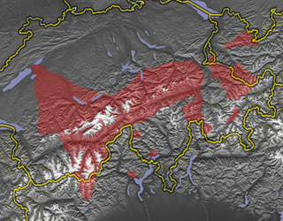
The Lepontine Alps are a mountain range in the north-western part of the Alps. They are located in Switzerland and Italy.

The river Ticino is the most important perennial left-bank tributary of the Po. It has given its name to the Swiss canton through which its upper portion flows.

Valais, more formally the Canton of Valais, is one of the 26 cantons forming the Swiss Confederation. It is composed of thirteen districts and its capital and largest city is Sion. The flag of the canton is made of thirteen stars representing the districts, on a white-red background.

The Great St Bernard Pass is the third highest road pass in Switzerland, at an elevation of 2,469 m (8,100 ft). It connects Martigny in the canton of Valais in Switzerland with Aosta in the region Aosta Valley in Italy. It is the lowest pass lying on the ridge between the two highest mountains of the Alps, Mont Blanc and Monte Rosa. It is located on the main watershed that separates the basin of the Rhône from that of the Po.
The Walser people are the speakers of the Walser German dialects, a variety of Highest Alemannic. They inhabit the region of the Alps of Switzerland and Liechtenstein, as well as the fringes of Italy and Austria. The Walser people are named after the Wallis (Valais), the uppermost Rhône valley, where they settled from roughly the 10th century in the late phase of the migration of the Alamanni, crossing from the Bernese Oberland; because of linguistic differences among the Walser dialects, it is supposed that there were two independent immigration routes.

The Grimsel Pass is a mountain pass in Switzerland, crossing the Bernese Alps at an elevation of 2,164 metres (7,100 ft). The pass connects the Haslital, the upper valley of the river Aare, with the upper valley of the Rhône. In so doing, and as the Aare is a tributary of the Rhine, the pass crosses the continental divide between the North Sea and the Mediterranean Sea.

Nufenen Pass is the highest mountain pass with a paved road within Switzerland. It lies between the summits of Pizzo Gallina (north) and the Nufenenstock (south).
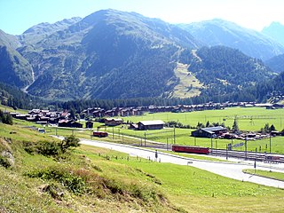
Bedretto is a municipality and a village in the Val Bedretto, the upper most part of the river Ticino. It belongs to the district of Leventina in the canton of Ticino in Switzerland.

The Toce is a river in Piedmont, Italy, which stretches the length of the Val d'Ossola from the Swiss border to Lake Maggiore into which it debouches near Fondotoce in the commune of Verbania. The river is 83.6 kilometres (51.9 mi) long and is formed in the upper Val Formazza by the confluence of a number of torrents in the plain of Riale.

Tourists are drawn to Switzerland's diverse landscape as well as the available activities, which take advantage of the Alpine climate and landscapes, in particular for skiing and mountaineering.
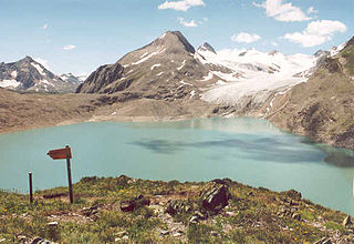
Griessee is a lake in Valais, Switzerland. The reservoir is located in the municipality of Ulrichen and can be reached by road from Nufenen Pass. The lake is fed by the Gries Glacier. Its surface area is 55.5 ha.
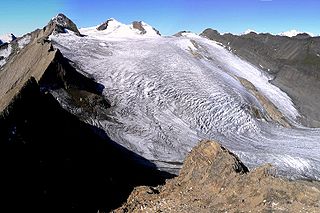
The Blinnenhorn (German) or Corno Cieco (Italian) is a mountain in the Lepontine Alps, located on the border between Italy and Switzerland. On the north-east side lies the Gries Glacier.

Pizzo Rotondo is a mountain in the Lepontine Alps. At 3,190 metres above sea level, it is the highest mountain lying on the border between the cantons of Ticino and Valais, as well as the highest summit of the Lepontine Alps lying between Nufenen Pass and Lukmanier Pass.

Pizzo Gallina is a 3,061-metre-high (10,043 ft) mountain in the Lepontine Alps of Switzerland, overlooking the Nufenen Pass.

The Grieshorn is a mountain of the Lepontine Alps, located on the Swiss-Italian border. With an altitude of 2,969 metres above sea level, it is the culminating point of the group lying between the Gries Pass, the San Giacomo Pass and the Nufenen Pass.

The Lötschberg is an Alpine mountain massif and usually associated with a major, historically important transit axis of the Alps in Switzerland with, at its core, the Lötschen Pass. The mountain pass, which culminates at nearly 2,700 metres above sea level, are part of the eastern Bernese Alps, whose main crest straddles the border between the cantons of Berne and Valais. The valleys concerned by the Lötschberg are those of the Kander in the Berner Oberland, with Kandersteg at the head of it, and a secluded side-valley of the Upper Valais, the Lötschental, with Ferden at the valley's entrance and at the bottom of the pass.

The High Alps are the parts of the Alps unsuitable for habitation or seasonal transhumance. This includes all regions higher than 3,000 m above sea level, as well as most regions between 2,500 m and 3,000 m. Alpine pastures are typically below 2,400 m but may exceptionally be located as high as 2,800 m.
Obergoms is the upper part of the Goms and a municipality in the district of Goms in the canton of Valais in Switzerland. It was formed on 1 January 2009 when the three municipalities Ulrichen, Obergesteln and Oberwald merged.
The Gotthard Massif or Saint-Gotthard Massif is a mountain range in the Alps in Switzerland, located at the border of four cantons: Valais, Ticino, Uri and Graubünden. It is delimited by the Nufenen Pass on the west, by the Furka Pass and the Oberalp Pass on the north and by the Lukmanier Pass on the east. The eponymous Gotthard Pass, lying at the heart of the massif, is the main route from north to south.
The Nufenestock is a mountain of the Lepontine Alps, located on the border between the Swiss cantons of Valais and Ticino. It lies between the Nufenen Pass and the Passo del Corno. On its south-west side it overlooks the lake of Gries.
