
The geography of Switzerland features a mountainous and landlocked country located in Western and Central Europe. Switzerland's natural landscape is marked by its numerous lakes and mountains. It is surrounded by five countries: Austria and Liechtenstein to the east, France to the west, Italy to the south and Germany to the north. Switzerland has a maximum north–south length of 220 kilometres (140 mi) and an east–west length of about 350 kilometres (220 mi).

Ticino, sometimes Tessin, officially the Republic and Canton of Ticino or less formally the Canton of Ticino, is one of the 26 cantons forming the Swiss Confederation. It is composed of eight districts and its capital city is Bellinzona. It is also traditionally divided into the Sopraceneri and the Sottoceneri, respectively north and south of Monte Ceneri. Red and blue are the colours of its flag.

The river Ticino is the most important perennial left-bank tributary of the Po. It has given its name to the Swiss canton through which its upper portion flows.

The Grisons or Graubünden, more formally the Canton of the Grisons or the Canton of Graubünden, is one of the twenty-six cantons of Switzerland. It has eleven districts, and its capital is Chur. The German name of the canton, Graubünden, translates as the "Grey Leagues", referring to the canton's origin in three local alliances, the Three Leagues. The other native names also refer to the Grey League: Grischùn in Sutsilvan, Grischun in the other forms of Romansh, and Grigioni in Italian. Rhaetia is the Latin name for the area. The Alpine ibex is the canton's heraldic symbol.

Valais, more formally, the Canton of Valais, is one of the 26 cantons forming the Swiss Confederation. It is composed of thirteen districts and its capital and largest city is Sion.

The Gotthard Road Tunnel in Switzerland runs from Göschenen in the canton of Uri at its northern portal, to Airolo in Ticino to the south, and is 16.9 kilometres (10.5 mi) in length below the St Gotthard Pass, a major pass of the Alps. At time of construction, in 1980, it was the longest road tunnel in the world; it is currently the fifth-longest. Although it is a motorway tunnel, part of the A2 from Basel to Chiasso, it consists of only one bidirectional tube with two lanes. With a maximum elevation of 1,175 metres (3,855 ft) at the tunnel's highest point, the A2 motorway has the lowest maximum elevation of any direct north-south road through the Alps.

The Gotthard Pass or St. Gotthard Pass at 2,106 m (6,909 ft) is a mountain pass in the Alps traversing the Saint-Gotthard Massif and connecting northern Switzerland with southern Switzerland. The pass lies between Airolo in the Italian-speaking canton of Ticino, and Andermatt in the German-speaking canton of Uri, and connects further Bellinzona and Lugano to Lucerne, Basel, and Zürich. The Gotthard Pass lies at the heart of the Gotthard, a major transport axis of Europe, and it is crossed by three traffic tunnels, each being the world's longest at the time of their construction: the Gotthard Rail Tunnel (1882), the Gotthard Road Tunnel (1980) and the Gotthard Base Tunnel (2016). With the Lötschberg to the west, the Gotthard is one of the two main north-south routes through the Swiss Alps.

The Grimsel Pass is a mountain pass in Switzerland, crossing the Bernese Alps at an elevation of 2,164 metres (7,100 ft). The pass connects the Haslital, the upper valley of the river Aare, with the upper valley of the Rhône. In so doing, and as the Aare is a tributary of the Rhine, the pass crosses the continental divide between the North Sea and the Mediterranean Sea.

The Bernina Pass is a high mountain pass in the Bernina Range of the Alps, in the canton of Graubünden (Grisons) in eastern Switzerland. It connects the famous resort town of St. Moritz in the Engadin valley with the Italian-speaking Val Poschiavo, which ends in the Italian town of Tirano in Valtellina. The pass lies a few kilometres east of Piz Bernina, and south of Val Minor.

Lukmanier Pass is a pass in the Swiss Alps.

Susten Pass is a mountain pass in the Swiss Alps. The pass road, built from 1938–1945, connects Innertkirchen in the canton of Bern with Wassen in the canton of Uri. A 300-metre long tunnel crosses the pass at 2,224 metres.
San Bernardino Pass is a high mountain pass in the Swiss Alps connecting the Hinterrhein and the Mesolcina (Misox) valleys between Thusis and Bellinzona. Located in the far eastern side of the Western Alps it is not to be confused with the Great St Bernard Pass and the Little St Bernard Pass. The top of the pass represents both the Italo-German language frontier and the watershed between the Po basin and the Rhine basin. Marscholsee is within the pass at an elevation of 2,053 m (6,736 ft).
The Rheinwaldhorn is the highest point in the Swiss canton of Ticino at 3,402 metres above sea level. It lies on the border between the cantons of Graubünden and Ticino, in the Adula massif, part of the St. Gotthard massif of the Adula Alps in southern Switzerland.

Monte Generoso is a mountain of the Lugano Prealps, located on the border between Switzerland and Italy and between Lake Lugano and Lake Como. The western and southern flanks of the mountain lie in the Swiss canton of Ticino, whilst the north-eastern flanks are in the Italian region of Lombardy.

Monte Ceneri is a mountain pass in the canton of Ticino in Switzerland. It connects the Magadino Plain and the Vedeggio Valley across the Lugano Prealps at an elevation of 554 metres (1,818 ft) above sea level. It provides the most direct route between the cities of Bellinzona and Lugano. Despite its name, Monte Ceneri is the lowest point on the crest between Monte Tamaro and the Camoghè.
Wildhaus Pass is a high mountain pass in the Alps in the canton of St. Gallen in Eastern Switzerland. The main road culminates at 1,090 metres, while the pass itself lies at an elevation of 1,027 metres above sea level.
Gries Pass is a mountain pass between Valais, Switzerland and Formazza, Italy. There is no road over the pass, from Nufenen Pass the paved road ends and a bridle path leads over to the Italian side. A high pressure gas pipeline runs over the pass, coming from the North Sea to Italy.

Pizzo Rotondo is a mountain in the Lepontine Alps. At 3,190 metres above sea level, it is the highest mountain lying on the border between the cantons of Ticino and Valais, as well as the highest summit of the Lepontine Alps lying between Nufenen Pass and Lukmanier Pass.

Piz Medel is a mountain in the Lepontine Alps, located on the border between the cantons of Ticino and Graubünden. At 3,210 metres (10,531 ft) above sea level it is the highest summit on the chain between Lukmanier Pass and Crap la Crusch. The mountain overlooks the Greina, an important pass connecting the cantons of Graubünden and Ticino.
The Gotthard Massif or Saint-Gotthard Massif is a mountain range in the Alps in Switzerland, located at the border of four cantons: Valais, Ticino, Uri and Graubünden. It is delimited by the Nufenen Pass on the west, by the Furka Pass and the Oberalp Pass on the north and by the Lukmanier Pass on the east. The eponymous Gotthard Pass, lying at the heart of the massif, is the main route from north to south.
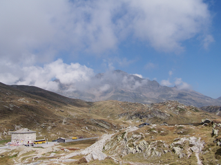
 View of Griesgletscher from the pass
 Another view from the pass
 Nufenen Pass


