Related Research Articles
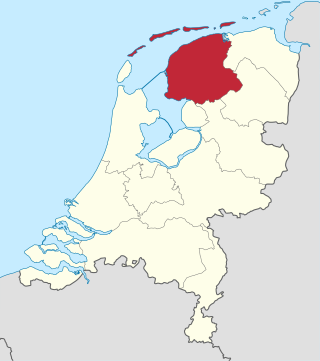
Friesland, historically and traditionally known as Frisia, named after the Frisians, is a province of the Netherlands located in the country's northern part. It is situated west of Groningen, northwest of Drenthe and Overijssel, north of Flevoland, northeast of North Holland, and south of the Wadden Sea. As of January 2020, the province had a population of 649,944 and a total area of 5,749 km2 (2,220 sq mi).

het Bildt is a former municipality in the province of Friesland in the northern Netherlands; its capital was Sint Annaparochie. The population was data missing in 2021. On 1 January 2018 it merged with the municipalities of Franekeradeel, Menameradiel and parts of Littenseradiel to form the new municipality Waadhoeke.

Wymbritseradeel was a rural municipality in the Dutch province of Friesland from 1984 until 2011. An earlier type of municipality of the same name existed from 1500 until 1984.

Boelenslaan is a village in Achtkarspelen municipality in Friesland province in the northern Netherlands.

The official language of the Netherlands is Dutch, spoken by almost all people in the Netherlands. Dutch is also spoken and official in Aruba, Bonaire, Belgium, Curaçao, Saba, Sint Eustatius, Sint Maarten and Suriname. It is a West Germanic, Low Franconian language that originated in the Early Middle Ages and was standardised in the 16th century.

Langweer is a village in Friesland in the municipality De Fryske Marren. The town was established in 1256, and has a population of 1,105 . Langweer has a rich trading history, and it is located at a small lake (Langweerderwielen).

De Wilp is a village in the Netherlands south of the town of Marum. It is largely located in the municipality of Westerkwartier in the province of Groningen, but a few houses of the village are in the municipality of Opsterland in the province of Friesland.

Eastergoa was one of the seven areas and one of the three Gaue within what is today the province of Friesland in the Netherlands.
A stins is a former stronghold or villa in the province of Friesland, the Netherlands. Many stinsen carry the name "state".

Peperga is a small village in Weststellingwerf in the province Friesland of the Netherlands. As of 2017, it has a population of 85 people, living in approximately 35 houses, and is characterized by detached houses, several businesses and a church. Peperga is located on the A32 between Wolvega and Steenwijk, with public transportation offering a service to the nearby villages of Steggerda and De Blesse.

Wâlterswâld is a village in Dantumadiel municipality, Friesland, the Netherlands. The village had a population of approximately 920 in 2017.

The Vetkopers and Schieringers were two opposing Frisian factional parties from the medieval period. They were responsible for a civil war that lasted for over a century (1350–1498) and which eventually led to the end of the so-called "Frisian freedom".

Eastrum is a village in Noardeast-Fryslân in the province of Friesland, the Netherlands. It had a population of around 188 in January 2017. Before 2019, the village was part of the Dongeradeel municipality.

Rinsumageast is a village in the Dantumadiel municipality of Friesland, the Netherlands. It had a population of around 965 in 2017.

De Westereen, Dutch: Zwaagwesteinde) is a village in the Dantumadiel municipality of Friesland, the Netherlands. It had a population of around 5,000 in 2017.
A grietman was a judge and administrator of a local district; this role was partly a forerunner of the current rural mayor in the province of Friesland, and partly the forerunner of a judge. East of the Lauwers river these judges were often referred to as 'redjeva' and west of the Lauwers river as 'grietman'.

Almenum is a historic locality in the northern Netherlands, near Midlum, Friesland the site of the first Christian church in Friesland. Saint Boniface set up a local church in the locality in 754. The location of the church is on the Terp of Almenum, a mound of earth about five meters high. Almenum is named after the place where someone called "Allaman" lived. The -um suffix is derived from the West Frisian word "hiem" meaning "home". An alternative explanation for the name of the locality is that it originally meant common lands for grazing cattle. In Icelandic this kind of land still uses the term "almenningurheim".
Zuidveen is a Dutch village just south of Steenwijk in the municipality of Steenwijkerland. It forms a single urban area with Steenwijk.

Hunsingo is a region in the province of Groningen, Netherlands, between the Reitdiep and Maarvliet. Hunsingo was one of three Ommelanden. It is bordered to the north by the Wadden Sea, to the east Fivelingo, in the west to the Westerkwartier and Friesland and in the south, Gorecht. The region corresponds to the current municipalities De Marne, Eemsmond, the majority of the municipalities of Bedum and Winsum and the former municipality of Middelstum.

The States of Friesland were the sovereign body that governed the province of Friesland under the Dutch Republic. They were formed in 1580 after the former Lordship of Frisia acceded to the Union of Utrecht and became one of the Seven United Netherlands. The Frisian stadtholder was their "First Servant". The board of Gedeputeerde Staten was the executive of the province when the States were not in session. The States of Friesland were abolished after the Batavian Revolution of 1795 when the Batavian Republic was founded. They were resurrected in name in the form of the Provincial States of Friesland under the Constitution of the Kingdom of the Netherlands.
References
- ↑ Hoitink, Yvette (2017-10-30). "Dutch term – Grietenij". Dutch Genealogy. Retrieved 2022-09-17.
- 1 2 3 4 5 6 7 8 9 10 11 Mol, Hans. The Frisian Popular Militias between 1480 and 1560. ISBN 978-94-6372-367-1. OCLC 1366294100.
- 1 2 A., Faber, J. (1973). Drie eeuwen Friesland : Economische en sociale ontwikkelingen van 1500 tot 1800. De Tille. OCLC 463181727.