Groot-Bijgaarden

Last updated
Groot-Bijgaarden Castle Grand-Bigard CH1aJPG.jpg
Groot-Bijgaarden Castle
Grand-Bigard CH1bJPG.jpg

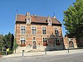
Groot-Bijgaarden (French : Grand-Bigard) is a village and deelgemeente in the municipality of Dilbeek, a suburb of Brussels, in Flanders, Belgium.

Contents

Toponymy

The name Bijgaarden is derived from the Germanic word for enclosure. The appellation "Great" (Groot) was attached to distinguish it from the smaller Klein-Bijgaarden nearby, now in the municipality of Sint-Pieters-Leeuw.

History

The earliest record of Groot-Bijgaarden is in the 12th century, when it appears as Bigardis. This derives from the house of Bijgaarden. They made various contributions to the abbeys of Affligem and Groot-Bijgaarden. As a result of different marriages, the village came into the hands of the Veele Family, an important family from Brussels.

After many donations, Groot-Bijgaarden was publicly sold to the counts of Königsegg-Erps in the second half of the 14th century.

It is a former municipality in the province of Flemish Brabant, Belgium. Since 1977 it is a subdivision (deelgemeente) of the municipality of Dilbeek.

Geography

Groot-Bijgaarden is situated between Dilbeek and Zellik. As of 31 December 2019 the population of Groot-Bijgaarden was 8.349. [1]

Attractions

Notes

  1. Current population figures only are provided by the municipal administration of Dilbeek

Coordinates: 50°52′N4°15′E / 50.867°N 4.250°E / 50.867; 4.250

Related Research Articles

<span class="mw-page-title-main">Anderlecht</span> Municipality of the Brussels-Capital Region, Belgium

Anderlecht is one of the 19 municipalities of the Brussels-Capital Region, Belgium. Located in the south-western part of the region, it is bordered by the City of Brussels, Forest, Molenbeek-Saint-Jean, and Saint-Gilles, as well as the Flemish municipalities of Dilbeek and Sint-Pieters-Leeuw. In common with all of Brussels' municipalities, it is legally bilingual (French–Dutch).

<span class="mw-page-title-main">Berchem-Sainte-Agathe</span> Municipality of the Brussels-Capital Region, Belgium

Berchem-Sainte-Agathe or Sint-Agatha-Berchem, often simply called Berchem, is one of the 19 municipalities of the Brussels-Capital Region, Belgium. Located in the north-western part of the region, it is bordered by Ganshoren, Koekelberg and Molenbeek-Saint-Jean, as well as the Flemish municipalities of Asse and Dilbeek. In common with all of Brussels' municipalities, it is legally bilingual (French–Dutch).

<span class="mw-page-title-main">Molenbeek-Saint-Jean</span> Municipality of the Brussels-Capital Region, Belgium

Molenbeek-Saint-Jean or Sint-Jans-Molenbeek, often simply called Molenbeek, is one of the 19 municipalities of the Brussels-Capital Region, Belgium. Located in the western part of the region, it is bordered by the City of Brussels, from which it is separated by the Brussels–Charleroi Canal, as well as by the municipalities of Anderlecht, Berchem-Sainte-Agathe, Dilbeek, Jette, and Koekelberg. The Molenbeek brook, from which it takes its name, flows through the municipality. In common with all of Brussels' municipalities, it is legally bilingual (French–Dutch).

<span class="mw-page-title-main">Dilbeek</span> Municipality in Flemish Community, Belgium

Dilbeek is a municipality in the province of Flemish Brabant, in the Flemish region of Belgium. The municipality comprises the villages of Dilbeek proper, Groot-Bijgaarden, Itterbeek, Schepdaal, Sint-Martens-Bodegem, and Sint-Ulriks-Kapelle. Dilbeek is located just outside the Brussels-Capital Region, in the Pajottenland, hence the local name Poort van het Pajottenland. Even though Dilbeek is located in the Dutch language area of Belgium, there is a French-speaking minority represented by 3 members on the 35-seat local council. It is a mostly residential community with some preserved rural areas and some industrial zones.

<span class="mw-page-title-main">Sint-Pieters-Leeuw</span> Municipality in Flemish Community, Belgium

Sint-Pieters-Leeuw is a Dutch-speaking municipality of Belgium located in the province of Flemish Brabant.

<span class="mw-page-title-main">Zaventem</span> Municipality in Flemish Community, Belgium

Zaventem is a Belgian municipality in the province of Flemish Brabant. It is located in the Dijleland area, one of the three large recreational areas which together form the Groene Gordel around the Brussels-Capital Region. The municipality comprises the subdivisions or deelgemeenten of Nossegem, Sint-Stevens-Woluwe, Sterrebeek and Zaventem proper. On 1 January 2006 Zaventem had a total population of 28,651. The total area is 27.62 square kilometres, which gives a population density of 1,037 inhabitants per km2. The official language is Dutch as it is within the Flemish Region. Zaventem is the home of Brussels Airport, together with neighbouring town of Diegem.

The Pajottenland is a distinct region within the Flemish Brabant province and the south-western part of the Brussels Region of Belgium. The region is located west-southwest of Brussels. The Pajottenland is predominantly farmland, with occasional gently rolling hills, and lies mostly between the rivers Dender and Zenne / Senne. The area has historically provided food and drink for the citizens of Brussels, especially Lambic beers, which are only produced here and in the Zenne valley where Brussels is.

<span class="mw-page-title-main">Ruisbroek, Flemish Brabant</span>

Ruisbroek is a village in the municipality of Sint-Pieters-Leeuw, in the Belgian province of Flemish Brabant. Previously a separate municipality, it became a deelgemeente of Sint-Pieters-Leeuw in 1977. Due to its proximity to the Brussels Capital Region, the Brussels-Charleroi Canal, the Zenne river, the railway Brussels—Mons—Quévy and the Brussels outer ring (R0), the ward is heavily urbanised.

<span class="mw-page-title-main">Groot-Bijgaarden Castle</span> 12th century castle in Flanders, Belgium

Groot-Bijgaarden Castle is a 12th-century castle in Groot-Bijgaarden in the municipality of Dilbeek, Flemish Brabant, Belgium. The castle was built for Almaric Bigard, the first lord of Bigard. Groot-Bijgaarden Castle is situated at an elevation of 47 meters.

<span class="mw-page-title-main">Brussels Ring</span>

The Brussels Ring numbered R0, is a ring road surrounding the city of Brussels as well as other smaller towns south of Brussels. It is about 75 kilometres (47 mi) long, with 2 or 3 lanes in each direction. While most of it is classified as a motorway (highway), part of it is merely an express route. It crosses the 3 regions of Belgium: its main part is situated in Flanders, whereas Wallonia comprises 18.2 kilometres (11.3 mi) of the total stretch and 5.5 kilometres (3.4 mi) is on Brussels territory.

<span class="mw-page-title-main">Belgian railway line 50</span> Railway line between Brussels and Ghent, Belgium

The Belgian railway line 50 is a railway line in Belgium connecting Brussels to Ghent. The first section between Ghent and Schellebelle was finished in 1837, offering a connection to Brussels through Dendermonde and Mechelen. The section between Schellebelle and Brussels was completed on 1 May 1856.

<span class="mw-page-title-main">Brussels tram route 19</span> Belgian tram route

The tram route 19 in Brussels, Belgium is a tram route operated by the STIB, which connects the Flemish town of Groot-Bijgaarden in the municipality of Dilbeek to the De Wand stop in Laeken in the municipality of the City of Brussels.

<span class="mw-page-title-main">Berchem-Sainte-Agathe railway station</span> Railway station in Brussels, Belgium

Berchem-Sainte-Agathe railway station or Sint-Agatha-Berchem railway station is a railway station in the municipality of Berchem-Sainte-Agathe in Brussels, Belgium. The station, operated by the National Railway Company of Belgium (NMBS/SNCB), is located on line 50, between Jette and Groot-Bijgaarden railway stations. It can be accessed from the Place de la Gare/Stationplein next to the Chaussée de Gand/Gentsesteenweg.

Sint-Ulriks-Kapelle is a village and deelgemeente of Dilbeek.

<span class="mw-page-title-main">Woluwe-Saint-Lambert</span> Municipality of the Brussels-Capital Region, Belgium

Woluwe-Saint-Lambert or Sint-Lambrechts-Woluwe is one of the 19 municipalities of the Brussels-Capital Region, Belgium. In common with all of Brussels' municipalities, it is legally bilingual (French–Dutch). In French, it is often spelt Woluwé-Saint-Lambert to reflect the Frenchified pronunciation of what was originally a Dutch place name, but the official spelling is without an accent. The Woluwe stream, from which it takes its name, flows through the municipality.

<span class="mw-page-title-main">Itterbeek</span>

Itterbeek is a historical village in the province of Flemish Brabant, Belgium, and since 1977 a submunicipality of Dilbeek.

<span class="mw-page-title-main">Schepdaal</span>

Schepdaal is a village and deelgemeente of Dilbeek in Flanders, Belgium.

Sint-Anna-Pede is a village in Itterbeek, Belgium, which is a deelgemeente of Dilbeek. It gets its name from the Pedebeek, the stream that flows through the village.

<span class="mw-page-title-main">Sint-Anna Church (Itterbeek)</span> Church in Dilbeek, Belgium

St. Anna's Church is a Roman Catholic church in Sint-Anna-Pede, in the municipality of Dilbeek, Belgium. It is depicted in The Blind Leading the Blind by Pieter Breughel the Elder.

<span class="mw-page-title-main">Haasdonk</span> Village in Flemish Region

Haasdonk is a village and deelgemeente (sub-municipality) of Beveren in East Flanders, Belgium. Haasdonk was an independent municipality until 1 January 1977, when it merged with Beveren as part of the fusion of municipalities in Belgium. It is located about 12 kilometres (7.5 mi) west of Antwerp.