Related Research Articles

The Buddhist Caves in Ajanta are approximately 30 rock-cut Buddhist cave monuments dating from the 2nd century BCE to about 480 CE in the Aurangabad district of Maharashtra state in India. The caves include paintings and rock-cut sculptures described as among the finest surviving examples of ancient Indian art, particularly expressive paintings that present emotions through gesture, pose and form.

A cave or cavern is a natural void in the ground, specifically a space large enough for a human to enter. Caves often form by the weathering of rock and often extend deep underground. The word cave can also refer to much smaller openings such as sea caves, rock shelters, and grottos, though strictly speaking a cave is exogene, meaning it is deeper than its opening is wide, and a rock shelter is endogene.
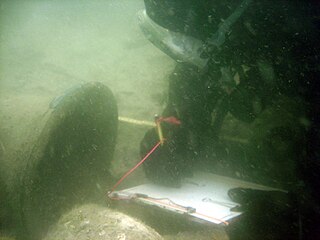
Maritime archaeology is a discipline within archaeology as a whole that specifically studies human interaction with the sea, lakes and rivers through the study of associated physical remains, be they vessels, shore-side facilities, port-related structures, cargoes, human remains and submerged landscapes. A specialty within maritime archaeology is nautical archaeology, which studies ship construction and use.

Masada is an ancient fortification in the Southern District of Israel situated on top of an isolated rock plateau, akin to a mesa. It is located on the eastern edge of the Judaean Desert, overlooking the Dead Sea 20 km (12 mi) east of Arad.

A mosaic is a pattern or image made of small regular or irregular pieces of colored stone, glass or ceramic, held in place by plaster/mortar, and covering a surface. Mosaics are often used as floor and wall decoration, and were particularly popular in the Ancient Roman world.
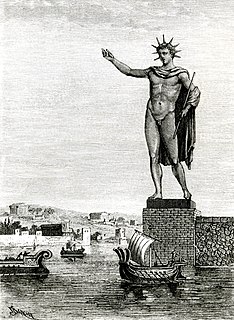
The Colossus of Rhodes was a statue of the Greek sun-god Helios, erected in the city of Rhodes, on the Greek island of the same name, by Chares of Lindos in 280 BC. One of the Seven Wonders of the Ancient World, it was constructed to celebrate the successful defence of Rhodes city against an attack by Demetrius Poliorcetes, who had besieged it for a year with a large army and navy. According to most contemporary descriptions, the Colossus stood approximately 70 cubits, or 33 metres high – approximately the height of the modern Statue of Liberty from feet to crown – making it the tallest statue in the ancient world. It collapsed during the earthquake of 226 BC, although parts of it were preserved. In accordance with a certain oracle, the Rhodians did not build it again. John Malalas wrote that Hadrian in his reign re-erected the Colossus, but he was mistaken. According to Suda, the Rhodians were called Colossaeans (Κολοσσαεῖς), because they erected the statue on the island.
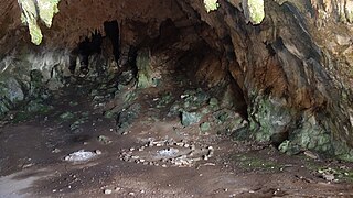
The Corycian Cave is located on the slopes of Mount Parnassus, in central Greece. In the mythology of the area, it is named after the nymph Corycia; however, its name etymologically derives from korykos, "knapsack". A modern name for the cave in some references is Sarantavli, meaning "forty rooms". This cave was sacred to the Corycian nymphs and the Muses, and a place of worship for Pan. This cave is also thought to be the ritual home of Dionysus.

Qumran is an archaeological site in the West Bank managed by Israel's Qumran National Park. It is located on a dry marl plateau about 1.5 km (1 mi) from the northwestern shore of the Dead Sea, near the Israeli settlement and kibbutz of Kalya.

A dry dock is a narrow basin or vessel that can be flooded to allow a load to be floated in, then drained to allow that load to come to rest on a dry platform. Dry docks are used for the construction, maintenance, and repair of ships, boats, and other watercraft.

The Mendip Hills is a range of limestone hills to the south of Bristol and Bath in Somerset, England. Running from Weston-super-Mare and the Bristol Channel in the west to the Frome valley in the east, the hills overlook the Somerset Levels to the south and the Chew Valley and other tributaries of the Avon to the north. The hills give their name to the local government district of Mendip, which administers most of the area. The higher, western part of the hills, covering 198 km2 (76 sq mi) has been designated an Area of Outstanding Natural Beauty (AONB), which gives it a level of protection comparable to a national park.

Burnham-on-Sea is a seaside town in Somerset, England, at the mouth of the River Parrett, upon Bridgwater Bay. Burnham was a small fishing village until the late 18th century when it began to grow because of its popularity as a seaside resort.

Russell Cave National Monument is a U.S. National Monument in northeastern Alabama, United States, close to the town of Bridgeport. The monument was established on May 11, 1961, when 310 acres (1.3 km2) of land were donated by the National Geographic Society to the American people. It is now administered and maintained by the National Park Service. The National Monument was listed on the National Register of Historic Places on October 15, 1966.
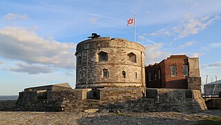
Calshot Castle is an artillery fort constructed by Henry VIII on the Calshot Spit, Hampshire, England, between 1539 and 1540. It formed part of the King's Device programme to protect against invasion from France and the Holy Roman Empire and defend Southampton Water as it met the Solent. The castle had a keep at its centre, surrounded by a curtain wall and a moat. Initially heavily armed, it had a garrison of 16 men and as many as 36 artillery guns. The castle continued in use for many years, surviving the English Civil War intact and being extensively modernised in the 1770s. During the 19th century, Calshot Castle was used by the coastguard as a base for combating smuggling. In 1894, however, fresh fears of a French invasion led to it being brought back into use as an artillery fort: a large coastal battery was constructed alongside the older castle and a boom built across Southampton Water, controlled from the castle.
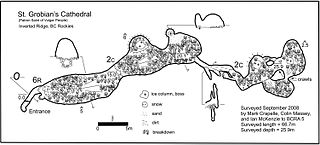
A cave survey is a map of all or part of a cave system, which may be produced to meet differing standards of accuracy depending on the cave conditions and equipment available underground. Cave surveying and cartography, i.e. the creation of an accurate, detailed map, is one of the most common technical activities undertaken within a cave and is a fundamental part of speleology. Surveys can be used to compare caves to each other by length, depth and volume, may reveal clues on speleogenesis, provide a spatial reference for other areas of scientific study and assist visitors with route-finding.

Gorham's Cave is a sea-level cave in the British overseas territory of Gibraltar. Though not a sea cave, it is often mistaken for one. Considered to be one of the last known habitations of the Neanderthals in Europe, the cave gives its name to the Gorham's Cave complex, which is a combination of four distinct caves of such importance that they are combined into a UNESCO World Heritage site, the only one in Gibraltar. The three other caves are Vanguard Cave, Hyaena Cave, and Bennett's Cave.
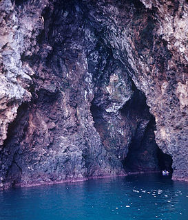
A sea cave, also known as a littoral cave, is a type of cave formed primarily by the wave action of the sea. The primary process involved is erosion. Sea caves are found throughout the world, actively forming along present coastlines and as relict sea caves on former coastlines. Some of the largest wave-cut caves in the world are found on the coast of Norway, but are now 100 feet or more above present sea level. These would still be classified as littoral caves. By contrast, in places like Thailand's Phang Nga Bay, solutionally formed caves in limestone have been flooded by the rising sea and are now subject to littoral erosion, representing a new phase of their enlargement.

Parc Cwm long cairn, also known as Parc le Breos burial chamber, is a partly restored Neolithic chambered tomb, identified in 1937 as a Severn-Cotswold type of chambered long barrow. The cromlech, a megalithic burial chamber, was built around 5850 years before present (BP), during the early Neolithic. It is about seven 1⁄2 miles (12 km) west south–west of Swansea, Wales, in what is now known as Coed y Parc Cwm at Parc le Breos, on the Gower Peninsula.

Herculaneum was an ancient town, located in the modern-day comune of Ercolano, Campania, Italy. Herculaneum was buried under volcanic ash and pumice in the eruption of Mount Vesuvius in AD 79.

Labweh, Laboué, Labwe or Al-Labweh is a village at an elevation of 950 metres (3,120 ft) on a foothill of the Anti-Lebanon mountains in Baalbek District, Baalbek-Hermel Governorate, Lebanon. It is famous because of the archaeological remains, like a Roman temple converted in a Byzantine fortress.

The La Garma cave complex is a parietal art-bearing paleoanthropological cave system in Cantabria, Spain. It is located just north of the village of Omoño, part of the municipality of Ribamontán al Monte. The cave complex is noted for one of the best preserved floors from the Paleolithic containing more than 4,000 fossils and more than 500 graphical units. It is part of the Cave of Altamira and Paleolithic Cave Art of Northern Spain World Heritage Site.
References
- ↑ Royal Geographical Society (Great Britain). (1903). The Geographical journal (Public domain ed.). Royal Geographical Society. pp. 131–. Retrieved 5 July 2012.
| | This Italian location article is a stub. You can help Wikipedia by expanding it. |