Groundwater banking

Last updated

Groundwater banking is a water management mechanism designed to increase water supply reliability. [1] Groundwater can be created by using dewatered aquifer space to store water during the years when there is abundant rainfall. It can then be pumped and used during years that do not have a surplus of water. [1] People can manage the use of groundwater to benefit society through the purchasing and selling of these groundwater rights. The surface water should be used first, and then the groundwater will be used when there is not enough surface water to meet demands. [2] The groundwater will reduce the risk of relying on surface water and will maximize expected income. [2] There are regulatory storage-type aquifer recovery and storage systems which when water is injected into it gives the right to withdraw the water later on. [2] Groundwater banking has been implemented into semi-arid and arid southwestern United States because this is where there is the most need for extra water. [2] The overall goal is to transfer water from low-value to high-value uses by bringing buyers and sellers together. [2]

Contents

Groundwater storage concepts

The bank is an aquifer used as an underground storage tank, and the recharge of water causes an increase in the volume of water stored in the aquifer to have increasing water levels. [2] In the case of a withdrawal there would be a decrease in water levels. [2] The amount of water depends also on a couple of other factors including groundwater pumping by other users, leakage, and natural recharge. [2] The recharge of water by land application or injection increases the volume of water, and then some of the water will be used at a future time. [2] It can be looked at as inputs of water minus outputs is equal to the change in water storage. [2]

Another aspect is the hydrology which is the difference between dynamic and static response to recharge and abstraction. [2] The water levels will rise or fall in the well during recharge and recovery. [2] Once recharge and recovery stops the water levels return to background levels, and one of the main issues is the change in static water levels after the dynamic response from recharge or recovery disappears. [2]

There can be some technical issues with the aquifer response to manage recharge and recovery. [2] If the aquifer is hydraulically connected to body of water on the surface there are increases in the water table elevation as the result of managed recharge. [2] This could increase the rate of discharge or decrease the amount of induced recharge, and both of these cause water to leave the basin. [2] The recharge and recovery could also affect the lateral and vertical groundwater flow into the aquifer. [2] There is not always a one-to-one correspondence between the volume of water and the change in storage. [2]

Methods of groundwater banking

Groundwater banking is accomplished in two ways: through in-lieu and direct recharge. [1] In-lieu recharge is storing water by utilizing surface water "in-lieu" of pumping groundwater, thereby storing an equal amount in the groundwater basin. [1] In-lieu recharge is the renewable surface water used to irrigate the farmland in place of using regular groundwater. [3] This is helping to save more groundwater because the water stays in the aquifer to be used later. [3] Direct recharge is storing water by allowing it to percolate directly to storage in the groundwater basin. [1] With direct recharge it floods an area so that water seeps through the ground to get to the aquifers. [3] The water is then pumped out when there is more of a demand with the use of recovery wells. [3]

Pros and cons

There are some disadvantages to retrieving this groundwater. As groundwater is withdrawn from below the surface, the ground above settles. [4] This settling of land, known as subsidence, can fracture roads and building foundations and can burst water, sewer, and gas lines. [4] This method hasn't been well tested yet, so there could be some negative impacts on the environment. Water is a public resource and this could make water become a private industry. [5]

Groundwater banking can be compared and contrasted to the use of surface reservoirs. Groundwater banking has many advantages over the use of surface reservoirs. The projects do not cost as much to construct and store the same amount, if not more, than the surface reservoirs. [6] The bank will have less of an impact on the environment than a surface reservoir. [6] The water that is in the bank will no longer be exposed to evaporation, but several feet per year of water is lost in the reservoirs. [6] It is more reliable to use when the climate is changing and can respond to seasonal changes better to manage the water than the surface reservoirs. [6]

There are also some disadvantages to groundwater banking over surface reservoirs. There are energy costs to recovering the water and these costs are usually more than the reservoirs. [6] There is also a pumping capacity and when the demands change during the year the productiveness can be limited. [6]

Not all groundwater is used when sold. Some groundwater is being studied for its benefits. Groundwater banking and aquifer storage systems are being explored to control flooding during times of high precipitation. [7]

The groundwater is being traded in many regions. There are trades even in the United States. The city of San Antonio, Texas is the largest city in the United States that relies solely on groundwater for its municipal supply. [7]

Feasibility of groundwater recharge on agricultural land

There have not been many successful trials of groundwater banking on agricultural land since the land is usually privately owned. [8] The owners have to be on board with the practice of groundwater banking knowing what the risks and best practices entail. [8] A study was done to find a Soil Agricultural Groundwater Banking Index (SAGBI) which evaluates soil suitability for the use of groundwater banking in California. [8] There are five factors that determine the feasibility of groundwater recharge on agricultural land: deep percolation, root zone residence time, topography, chemical limitations, and soil surface conditions. [8] The five factors were modeled using United States Department of Agriculture Natural Resources Conservation Service (USDA-NRCS) digital soil survey data. [8]

For the deep percolation factor a high rate of water transmission through the soil profile and into the aquifer below is the key to successful groundwater banking. [8] It becomes more important when there is flooding since it could be used as the main water source. [8] It is derived from the saturated hydraulic conductivity of the limiting layer. [8] Saturated hydraulic conductivity measures soil permeability when the soil is saturated. [8]

When looking at root zone residence time factor it was found that a prolonged duration of saturated conditions in the root zone has the possibility to cause damage to perennial crops. [8] If the soil causes a bud break it is more likely that the crop will become damaged. [8] Most crops are not able to withstand long periods of saturated conditions in the root zone. [8] The root zone residence time estimates the likelihood of having good enough drainage within the root zone once water is applied. [8]

The topography of land for spreading water across fields has the best outcome when there is level topography. [8] Level topography works the best because it holds water better on the landscape which allows infiltration across large areas. [8] Infiltration reduces ponding and minimizes erosion by runoff. [8]

The chemical limitations factor is related to the salinity which is a threat to the sustainability of agriculture and groundwater. [8] This factor was determined by electrical conductivity (EC) of the soil which measures the soil salinity. [8] The best soil has the lowest levels of salinity. [8] Soil also has pesticides and nitrate, but it is unable to be evaluated due to the dependency on management history. [8]

The surface condition factor is when banking by flood spreading can change the soil surfaces physical conditions. [8] Infiltrations limits can be caused by quality and depth of water that could lead to the destruction of aggregates, the formation of physical crusts, and compaction. [8] To determine soil condition two factors were examined: soil erosion factor and sodium absorption ratio (SAR). [8]

To determine the feasibility of groundwater banking each of the five factors were assigned a weight to how significant it was, and then a SAGBI score was calculated. [8] The weights were 27.5% deep percolation, 27.5% root zone residence time, 20% topography, 20% chemical limitations, and 5% surface conditions. [8] Of the 17.5 million acres of agricultural land examined only 5 million acres were considered soils with excellent, good, and moderately good suitability. [8]

Agricultural groundwater banking can be associated with financial risk which may cause crop loss, so in the end, the loss may exceed the benefits of water saving. [8] Adoption of this practice would require support to protect growers from risk of crop failure. [8]

Groundwater accounting system

The accounting system tracks the recharge and withdrawals of stored water and it can include a market system to reserve the storage of water. [2] Depositors could earn credits for the recharge of water which can be used later on for the water recovered from the bank. [2] The banking system could then be set up to allow trading of credits. [2] There are several objectives of the water bank accounting system: track water deposits, withdrawals, and to control the amount, timing, and location of withdrawals by the participants. [2] If groundwater is not regulated there is more of a chance for freeriding and overuse. [2] There needs to be sustainability of the system in order to continue with the operation of the system or there would be no point to using it. [2]

The accounting method that will be used is the double-entry accounting method, so every transaction is recorded as a debit and a credit in separate ledger accounts. [2] This also allows for tracking of inventory in asset accounts and claims to inventory in ownership accounts. [2] Deposits happen when more water is stored in an aquifer than there is supposed to be. [2] The recharge of water by a member would be a credit in a member's account and a liability in the bank's account. [2] For the bank to be successful then both ledgers have to be balanced, so the right to water in a member's accounts should be equal to the amount of water that can be recovered from the system. [2] If the right to water is greater than liabilities then the bank is insolvent, and this will become a problem when a drought occurs. [2]

There are some issues that could arise from using this water bank accounting system. These problems were evaluated for the Las Posas Basin groundwater bank and Fox Canyon Groundwater Management Agency (FCGMA) has jurisdiction over the project. [2] FCGMA reported that the accumulation of credits has been increasing for banks. [2] What can happen is the accumulated credits can become greater than the annual abstraction rate. [2] The volume of credits accumulating exceed the amount of water that can be taken out during a short-time period. [2] This will cause a threat to the regional groundwater resource or even depressions in groundwater elevations, land subsidence, and seawater intrusion. [2]

Regulatory framework

The banking systems need regulatory control over the basin to implement the withdrawal rates and to ensure that other participants will not extract too much stored water. [2] The best scenario would be that the bank owner or participants would be the main users to ensure that abstractions are controlled. [2] If this is not the case, then there must be another way to control the number and amount of abstractions happening. [2] It needs to be clear who has priority over stored water, so that when abstractions are constrained it is known who will get the water first. [2] There can be problems when multiple entities have jurisdiction over a project, and this can cause regulatory and organizational challenges. [2] There are some generally accepted rules and also many of the issues are handled through state-specific concepts. [2] One of the main requirements is an action needs to be in place so that the stored water is not being abstracted by other users who are not involved in the system. [2] These frameworks rely on the knowledge of hydrogeology to determine the success of a system, and the systems need to provide benefits to prove it was worth building. [2]

Economics

The different projects can become economically efficient by maximizing the benefits of the limited resource (water). [9] To maximize efficiency the users need to find where marginal cost is equal to marginal benefit. [9] It is important for supply to equal demand like in the figure below. The use of water becomes a negative externality when there is rivalry and the property rights are not well-defined. [9] The way to eliminate some of the negative externality is there can be a tax placed on the resource to increase the marginal cost. [9] When they tax the right amount the user will use the resource at the socially acceptable level. [9] The other way to affect the externality is to create a subsidy. A subsidy will increase the marginal benefit in order to get to the socially accepted level of use for the resource. [9]

Simple supply and demand.svg

Water is not a homogeneous commodity for several reasons which include sensitivity to location, time of use, form of the water, and administrative responses. [9] The use of groundwater banking can make water a more homogenous commodity. This can create a market value which will enhance private investment increasing the benefits. [9] It will also align marginal benefit with marginal cost causing the market to come to an economically efficient level. [9]

Water has high transaction costs and create market barriers which devalues the use to society restricting the reallocation of resources. [9] The demand does not change when there is a market barrier so there will be many unpleasant people if they do not get their share of water. [9] If a bank is in the process of being made the removal of market-access barriers can be part of the negotiations, but it is not necessarily the bank itself that is the cause. [9] Groundwater banking could reduce transaction costs because each individual won't have to analyze each transaction. [9]

See also

Related Research Articles

<span class="mw-page-title-main">Aquifer</span> Underground layer of water-bearing permeable rock

An aquifer is an underground layer of water-bearing, permeable rock, rock fractures, or unconsolidated materials. Groundwater from aquifers can be extracted using a water well. Aquifers vary greatly in their characteristics. The study of water flow in aquifers and the characterization of aquifers is called hydrogeology. Related terms include aquitard, which is a bed of low permeability along an aquifer, and aquiclude, which is a solid, impermeable area underlying or overlying an aquifer, the pressure of which could create a confined aquifer. The classification of aquifers is as follows: Saturated versus unsaturated; aquifers versus aquitards; confined versus unconfined; isotropic versus anisotropic; porous, karst, or fractured; transboundary aquifer.

<span class="mw-page-title-main">Ogallala Aquifer</span> Water table aquifer beneath the Great Plains in the United States

The Ogallala Aquifer is a shallow water table aquifer surrounded by sand, silt, clay, and gravel located beneath the Great Plains in the United States. As one of the world's largest aquifers, it underlies an area of approximately 174,000 sq mi (450,000 km2) in portions of eight states. It was named in 1898 by geologist N. H. Darton from its type locality near the town of Ogallala, Nebraska. The aquifer is part of the High Plains Aquifer System, and resides in the Ogallala Formation, which is the principal geologic unit underlying 80% of the High Plains.

<span class="mw-page-title-main">Groundwater</span> Water located beneath the ground surface

Groundwater is the water present beneath Earth's surface in rock and soil pore spaces and in the fractures of rock formations. About 30 percent of all readily available freshwater in the world is groundwater. A unit of rock or an unconsolidated deposit is called an aquifer when it can yield a usable quantity of water. The depth at which soil pore spaces or fractures and voids in rock become completely saturated with water is called the water table. Groundwater is recharged from the surface; it may discharge from the surface naturally at springs and seeps, and can form oases or wetlands. Groundwater is also often withdrawn for agricultural, municipal, and industrial use by constructing and operating extraction wells. The study of the distribution and movement of groundwater is hydrogeology, also called groundwater hydrology.

<span class="mw-page-title-main">Vadose zone</span> Unsaturated aquifer above the water table

The vadose zone, also termed the unsaturated zone, is the part of Earth between the land surface and the top of the phreatic zone, the position at which the groundwater is at atmospheric pressure. Hence, the vadose zone extends from the top of the ground surface to the water table.

<span class="mw-page-title-main">Edwards Aquifer</span> Source of drinking water in Texas

The Edwards Aquifer is one of the most prolific artesian aquifers in the world. Located on the eastern edge of the Edwards Plateau in the U.S. state of Texas, it is the source of drinking water for two million people, and is the primary water supply for agriculture and industry in the aquifer's region. Additionally, the Edwards Aquifer feeds the Comal and San Marcos springs, provides springflow for recreational and downstream uses in the Nueces, San Antonio, Guadalupe, and San Marcos river basins, and is home to several unique and endangered species.

<span class="mw-page-title-main">Water balance</span> Looks at how water moves in a closed system

The law of water balance states that the inflows to any water system or area is equal to its outflows plus change in storage during a time interval. In hydrology, a water balance equation can be used to describe the flow of water in and out of a system. A system can be one of several hydrological or water domains, such as a column of soil, a drainage basin, an irrigation area or a city. Water balance can also refer to the ways in which an organism maintains water in dry or hot conditions. It is often discussed in reference to plants or arthropods, which have a variety of water retention mechanisms, including a lipid waxy coating that has limited permeability.

<span class="mw-page-title-main">Groundwater recharge</span> Groundwater that recharges an aquifer

Groundwater recharge or deep drainage or deep percolation is a hydrologic process, where water moves downward from surface water to groundwater. Recharge is the primary method through which water enters an aquifer. This process usually occurs in the vadose zone below plant roots and is often expressed as a flux to the water table surface. Groundwater recharge also encompasses water moving away from the water table farther into the saturated zone. Recharge occurs both naturally and through anthropogenic processes, where rainwater and or reclaimed water is routed to the subsurface.

Overdrafting is the process of extracting groundwater beyond the equilibrium yield of an aquifer. Groundwater is one of the largest sources of fresh water and is found underground. Groundwater depletion is comparable to a bank account in which more money is withdrawn than deposited. The primary cause of groundwater depletion is the excessive pumping of groundwater up from underground aquifers.

Dryland salinity is a natural process for soil, just like other processes such as wind erosion. Salinity degrades land by an increase in soil salt concentration in the environment, watercourse or soil in unirrigated landscapes, being in excess of normal soil salt concentrations in dryland regions.

<span class="mw-page-title-main">SahysMod</span>

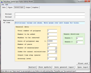
SahysMod is a computer program for the prediction of the salinity of soil moisture, groundwater and drainage water, the depth of the watertable, and the drain discharge in irrigated agricultural lands, using different hydrogeologic and aquifer conditions, varying water management options, including the use of ground water for irrigation, and several crop rotation schedules, whereby the spatial variations are accounted for through a network of polygons.

Water resources management is a significant challenge for Mexico. The country has in place a system of water resources management that includes both central (federal) and decentralized institutions. Furthermore, water management is imposing a heavy cost to the economy.

<span class="mw-page-title-main">Water resources</span> Sources of water that are potentially useful

Water resources are natural resources of water that are potentially useful for humans, for example as a source of drinking water supply or irrigation water. 97% of the water on the Earth is salt water and only three percent is fresh water; slightly over two thirds of this is frozen in glaciers and polar ice caps. The remaining unfrozen freshwater is found mainly as groundwater, with only a small fraction present above ground or in the air. Natural sources of fresh water include surface water, under river flow, groundwater and frozen water. Artificial sources of fresh water can include treated wastewater and desalinated seawater. Human uses of water resources include agricultural, industrial, household, recreational and environmental activities.

<span class="mw-page-title-main">Agricultural hydrology</span>

Agricultural hydrology is the study of water balance components intervening in agricultural water management, especially in irrigation and drainage.

Aquifer storage and recovery (ASR) is the direct injection of surface water supplies such as potable water, reclaimed water, or river water into an aquifer for later recovery and use. The injection and extraction is often done by means of a well. In areas where the rainwater cannot percolate the soil or where it is not capable of percolating it fast enough and where the rainwater is thus diverted to rivers, rainwater ASR could help to keep the rainwater within an area. ASR is used for municipal, industrial and agricultural purposes.

<span class="mw-page-title-main">Environmental effects of irrigation</span>

The environmental effects of irrigation relate to the changes in quantity and quality of soil and water as a result of irrigation and the subsequent effects on natural and social conditions in river basins and downstream of an irrigation scheme. The effects stem from the altered hydrological conditions caused by the installation and operation of the irrigation scheme.

<span class="mw-page-title-main">Water resources management in Argentina</span>

Water resources management (WRM) functions in Argentina are handled by multiple institutions operating at the national, provincial, and river basin level, with a variety of functions and jurisdictions. On the national level, the National Institute for Water and the Environment (INA) and the National Water and Sanitation Utility (AySA) are charged with the duties of researching, water resources preservation, developing services, and implementing water projects.

<span class="mw-page-title-main">Groundwater-dependent ecosystems</span>

Groundwater-Dependent Ecosystems are ecosystems that rely upon groundwater for their continued existence. Groundwater is water that has seeped down beneath Earth's surface and has come to reside within the pore spaces in soil and fractures in rock, this process can create water tables and aquifers, which are large storehouses for groundwater. An ecosystem is a community of living organisms interacting with the nonliving aspects of their environment. With a few exceptions, the interaction between various ecosystems and their respective groundwater is a vital yet poorly understood relationship, and their management is not nearly as advanced as in-stream ecosystems.

Costa Rica is divided into three major drainage basins encompassing 34 watersheds with numerous rivers and tributaries, one major lake used for hydroelectric generation, and two major aquifers that serve to store 90% of the municipal, industrial, and agricultural water supply needs of Costa Rica. Agriculture is the largest water user demanding around 53% of total supplies while the sector contributes 6.5% to the Costa Rica GDP. About a fifth of land under cultivation is being irrigated by surface water. Hydroelectric power generation makes up a significant portion of electricity usage in Costa Rica and much of this comes from the Arenal dam.

<span class="mw-page-title-main">Stormwater harvesting</span>

Stormwater harvesting or Stormwater reuse is the collection, accumulation, treatment or purification, and storage of stormwater for its eventual reuse. While rainwater harvesting collects precipitation primarily from rooftops, stormwater harvesting deals with collection of runoff from creeks, gullies, ephemeral streams, underground conveyances. It can also include catchment areas from developed surfaces, such as roads or parking lots, or other urban environments such as parks, gardens and playing fields.

<span class="mw-page-title-main">Water storage</span>

Water storage is a broad term referring to storage of both potable water for consumption, and non potable water for use in agriculture. In both developing countries and some developed countries found in tropical climates, there is a need to store potable drinking water during the dry season. In agriculture water storage, water is stored for later use in natural water sources, such as groundwater aquifers, soil water, natural wetlands, and small artificial ponds, tanks and reservoirs behind major dams. Storing water invites a host of potential issues regardless of that water’s intended purpose, including contamination through organic and inorganic means.

References

  1. 1 2 3 4 5 Semitropic Water Storage District. FAQs. <http://www.semitropic.com/GndwtrBankFAQs.htm>.
  2. 1 2 3 4 5 6 7 8 9 10 11 12 13 14 15 16 17 18 19 20 21 22 23 24 25 26 27 28 29 30 31 32 33 34 35 36 37 38 39 40 41 42 43 Maliva, Robert G. "Groundwater Banking: Opportunities And Management Challenges." Water Policy 16.1 (2014): 144-156. Academic Search Complete. Web. 18 Nov. 2015.
  3. 1 2 3 4 "Recharge and Facilities". www.azwaterbank.gov. Retrieved 2015-10-21.
  4. 1 2 "Archived copy" (PDF). Archived from the original (PDF) on 2013-09-07. Retrieved 2014-01-26.{{cite web}}: CS1 maint: archived copy as title (link)
  5. "Groundwater Banking – Water Education Foundation". www.watereducation.org. Retrieved 2015-09-28.
  6. 1 2 3 4 5 6 mavensnotebook.com http://mavensnotebook.com/the-notebook-file-cabinet/groundwater-banking/ . Retrieved 2015-10-21.{{cite web}}: Missing or empty |title= (help)[ permanent dead link ]
  7. 1 2 http://www.cpo.noaa.gov/sites/cpo/Projects/SARP/CaseStudies/2013/Russian%20River%20Basin%20CA_Case%20Study%20Factsheet_Extreme%20Weather%20Events_2013-2-6v1.pdf [ bare URL PDF ]
  8. 1 2 3 4 5 6 7 8 9 10 11 12 13 14 15 16 17 18 19 20 21 22 23 24 25 26 27 28 O'Greene, A.T. (April 2015). "Soil suitability index identifies potential areas for groundwater banking on agricultural lands". California Agriculture. 69 (2): 75–84. doi: 10.3733/ca.v069n02p75 . S2CID   53658437 via University of California, Division of Agriculture and Natural Resources.
  9. 1 2 3 4 5 6 7 8 9 10 11 12 13 Contor, Bryce (August 2009). "Groundwater Banking and the Conjunctive Management of Groundwater and Surface Water in the Upper Snake River Basin of Idaho". Idaho Water Resources Research Institute Technical Completion Report.