Grover, South Dakota

Last updated

Grover is an unincorporated community in Codington County, in the U.S. state of South Dakota. [1]

History

Grover had its start in 1888 when the Great Northern Railway was extended to that point. [2] A post office was established at Grover in 1888, and remained in operation until 1958. [3]

Related Research Articles

<span class="mw-page-title-main">Hamlin County, South Dakota</span> County in South Dakota, United States

Hamlin County is a county in the U.S. state of South Dakota. As of the 2020 census, the population was 6,164. Its county seat is Hayti. The county was created in 1873 and organized in 1878. It was named for Hannibal Hamlin, Lincoln's first vice-president.

<span class="mw-page-title-main">Grant County, South Dakota</span> County in South Dakota, United States

Grant County is a county in the U.S. state of South Dakota. As of the 2020 census, the population was 7,556. The county seat is Milbank. The county was founded in 1873 and organized in 1878. It is named for Ulysses S. Grant, 18th President of the United States.

<span class="mw-page-title-main">Deuel County, South Dakota</span> County in South Dakota, United States

Deuel County is a county in the U.S. state of South Dakota. As of the 2020 census, the population was 4,295. Its county seat is Clear Lake. The county was created in 1862, and was organized in 1878. It is named for Jacob Deuel, a legislator in 1862.

<span class="mw-page-title-main">Day County, South Dakota</span> County in South Dakota, United States

Day County is a county in the U.S. state of South Dakota. As of the 2020 census, the population was 5,449. Its county seat is Webster. The county is named for Merritt H. Day, pioneer and 1879 Dakota Territory legislator.

<span class="mw-page-title-main">Codington County, South Dakota</span> County in South Dakota, United States

Codington County is a county in the U.S. state of South Dakota. As of the 2020 census, the population was 28,325. Its county seat is Watertown. The county was created in 1877 and organized in 1878. It is named for Rev. George S. S. Codington, Dakota Territory legislator.

<span class="mw-page-title-main">Clark County, South Dakota</span> County in South Dakota, United States

Clark County is a county in the U.S. state of South Dakota. As of the 2020 census, the population was 3,837. Its county seat is Clark. The county was created in 1873 and organized in 1881. It was named for Newton Clark, a Dakota Territory legislator in 1873.

<span class="mw-page-title-main">Big Sioux River</span> River in eastern South Dakota and northwestern Iowa

The Big Sioux River is a tributary of the Missouri River in eastern South Dakota and northwestern Iowa in the United States. It flows generally southwardly for 419 mi (674 km), and its watershed is 9,006 sq mi (23,330 km2). The United States Board on Geographic Names settled on "Big Sioux River" as the stream's name in 1931. The river was named after the Lakota people which was known by them as Tehankasandata, or Thick Wooded River.

<span class="mw-page-title-main">Carpenter, South Dakota</span> Unincorporated community in South Dakota, United States

Carpenter is an unincorporated community in Clark County, South Dakota, United States. It is not tracked by the Census Bureau. Carpenter has the post office serving the ZIP code 57322 area. Despite the city's size of one square city block, businesses such as Agtegra, the Carpenter Cafe, Dick's Garage, and the post office flourish here.

There are over a dozen lakes named Mud Lake within the U.S. state of South Dakota. According to the Federal Writers' Project, these lakes were so named on account of the muddy condition of the lake bed or lake shore.

<span class="mw-page-title-main">Lake Traverse Indian Reservation</span> Indian reservation in United States, Sisseton Wahpeton Oyate

The Lake Traverse Indian Reservation is the homeland of the federally recognized Sisseton Wahpeton Oyate, a branch of the Santee Dakota group of Native Americans. Most of the reservation covers parts of five counties in northeastern South Dakota, while smaller parts are in two counties in southeastern North Dakota, United States.

Appleby is an unincorporated community in Codington County, in the U.S. state of South Dakota.

Elrod is an unincorporated community in Clark County, in the U.S. state of South Dakota.

Esmond is an unincorporated community in Kingsbury County, in the U.S. state of South Dakota.

Kampeska is an unincorporated community in Codington County, in the U.S. state of South Dakota.

Argonne is an extinct town located in Miner County, in the U.S. state of South Dakota.

Junius is an unincorporated community in Lake County, in the U.S. state of South Dakota.

Melham is an unincorporated community in Clark County, in the U.S. state of South Dakota.

Osceola is an unincorporated community in western Kingsbury County, in the U.S. state of South Dakota. The community is located on the South Fork Pearl River and is approximately six miles southwest of Bancroft.

Spain is an unincorporated community in Marshall County, in the U.S. state of South Dakota.

Thomas is an unincorporated rural hamlet in Hamlin County in the U.S. state of South Dakota. The hamlet is part of a larger township, and the township hall is located in Thomas. There is also a small cemetery.

References

  1. U.S. Geological Survey Geographic Names Information System: Grover, South Dakota
  2. Federal Writers' Project (1940). South Dakota place-names, v.1-3. University of South Dakota. p. 40.
  3. "Codington County". Jim Forte Postal History. Retrieved January 30, 2015.
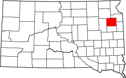
44°48′50″N97°16′07″W / 44.81389°N 97.26861°W / 44.81389; -97.26861