Waverly, South Dakota

Last updated

Waverly, South Dakota
USA South Dakota location map.svg
Red pog.svg
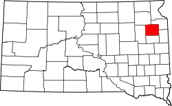
Waverly
Location in South Dakota
Coordinates: 44°59′55″N96°58′27″W / 44.99861°N 96.97417°W / 44.99861; -96.97417
CountryUnited States
State South Dakota
County Codington
Area
[1]
  Total1.02 sq mi (2.64 km2)
  Land1.02 sq mi (2.64 km2)
  Water0.00 sq mi (0.00 km2)
Elevation
[2]
1,988 ft (606 m)
Population
 (2020) [3]
  Total22
  Density21.61/sq mi (8.35/km2)
Time zone UTC-6 (CST)
  Summer (DST) UTC-5 (CDT)
ZIP code
57201
Area code 605
FIPS code 46-69420
GNIS feature ID2628853 [2]

Waverly is an unincorporated community and census-designated place (CDP) in Codington County, South Dakota, United States. The population was 22 at the 2020 census. [4]

Contents

The community derives its name from the Waverley Novels. [5]

Geography

Waverly is located in eastern Codington County 15 miles (24 km) northeast of Watertown, the county seat. It is 4 miles (6 km) east of Exit 185 on Interstate 29.

According to the United States Census Bureau, the Waverly CDP has a total area of 1.0 square mile (2.6 km2), all land.

Demographics

Historical population
CensusPop.Note
2020 22
U.S. Decennial Census [6]

Related Research Articles

<span class="mw-page-title-main">Codington County, South Dakota</span> County in South Dakota, United States

Codington County is a county in the U.S. state of South Dakota. As of the 2020 census, the population was 28,325. Its county seat is Watertown. The county was created in 1877 and organized in 1878. It is named for Rev. George S. S. Codington, Dakota Territory legislator.

<span class="mw-page-title-main">Florence, South Dakota</span> Town in South Dakota, United States

Florence is a town in northwestern Codington County, South Dakota, United States. It is part of the Watertown, South Dakota Micropolitan Statistical Area. The population was 337 at the 2020 census.

<span class="mw-page-title-main">Henry, South Dakota</span> Town in South Dakota, United States

Henry is a town in southwestern Codington County, South Dakota, United States. The population was 256 at the 2020 census. It is part of the Watertown, South Dakota Micropolitan Statistical Area.

<span class="mw-page-title-main">Kranzburg, South Dakota</span> Town in South Dakota, United States

Kranzburg is a town in Codington County, South Dakota, United States. The population was 163 at the 2020 census. It is part of the Watertown, South Dakota Micropolitan Statistical Area.

<span class="mw-page-title-main">South Shore, South Dakota</span> Town in South Dakota, United States

South Shore is a town in Codington County, South Dakota, United States. The population was 189 at the 2020 census. It is part of the Watertown, South Dakota Micropolitan Statistical Area.

<span class="mw-page-title-main">La Plant, South Dakota</span> Census-designated place in South Dakota, United States

La Plant is a census-designated place (CDP) in Dewey County, South Dakota, United States. The population was 167 at the 2020 census. It is within the Cheyenne River Indian Reservation.

<span class="mw-page-title-main">Harrison, South Dakota</span> Census-designated place in South Dakota, United States

Harrison is an unincorporated community and census-designated place (CDP) in Douglas County, South Dakota, United States. The population was 55 at the 2020 census.

<span class="mw-page-title-main">Vivian, South Dakota</span> Census-designated place in South Dakota, United States

Vivian is an unincorporated community and census-designated place (CDP) in Lyman County, South Dakota, United States. The population was 98 at the 2020 census.

<span class="mw-page-title-main">Colonial Pine Hills, South Dakota</span> CDP in South Dakota, United States

Colonial Pine Hills is a census-designated place (CDP) and unincorporated community in Pennington County, South Dakota, United States. The population was 1,903 at the 2020 census.

<span class="mw-page-title-main">Oglala, South Dakota</span> CDP in South Dakota, United States

Oglala is a census-designated place (CDP) in West Oglala Lakota Unorganized Territory equivalent, Oglala Lakota County, South Dakota, United States. The population was 1,282 at the 2020 census. Its location is in the northwest of the Pine Ridge Indian Reservation.

<span class="mw-page-title-main">Pine Ridge, South Dakota</span> CDP in South Dakota, United States

Pine Ridge is a census-designated place (CDP) and the most populous community in Oglala Lakota County, South Dakota, United States. The population was 3,138 at the 2020 census. It is the tribal headquarters of the Oglala Sioux Tribe on the Pine Ridge Indian Reservation.

Chester is an unincorporated community and census-designated place (CDP) in Lake County, South Dakota, United States. The population was 257 as of the 2020 census. Chester has been assigned the ZIP code of 57016.

Saint Onge is an unincorporated community and census-designated place (CDP) in Lawrence County, South Dakota, United States. As of the 2020 census, the population was 170.

Winfred is an unincorporated community and census-designated place (CDP) in Lake County, South Dakota, United States, approximately 12 miles (19 km) west of Madison. The population was 38 as of the 2020 census.

Shindler is an unincorporated community and census-designated place (CDP) in Lincoln County, South Dakota, United States. The population was 607 at the 2020 census.

<span class="mw-page-title-main">Running Water, South Dakota</span> Census-designated place in South Dakota, United States

Running Water is a census-designated place (CDP) in Bon Homme County, South Dakota, United States. The population was 47 at the 2020 census.

Lake Poinsett is a census-designated place (CDP) in Hamlin and Brookings counties in South Dakota, United States. The population was 501 at the 2020 census.

Crocker is an unincorporated community and census-designated place (CDP) in Clark County, South Dakota, United States. The population was 19 at the 2020 census.

Encore at Monroe is a gated community and census-designated place (CDP) located in Monroe Township, Middlesex County, in the U.S. state of New Jersey. It is in the western part of the township, bordered to the south by Clearbrook. It is 3 miles (5 km) southwest of Jamesburg, 15 miles (24 km) south of New Brunswick, 6 miles (10 km) northeast of Hightstown, and 18 miles (29 km) northeast of Trenton.

Plainview Colony is a Hutterite colony and census-designated place (CDP) in Edmunds County, South Dakota, United States. It was first listed as a CDP prior to the 2020 census. The population of the CDP was 100 at the 2020 census.

References

  1. "ArcGIS REST Services Directory". United States Census Bureau. Retrieved October 15, 2022.
  2. 1 2 U.S. Geological Survey Geographic Names Information System: Waverly, South Dakota
  3. "Census Population API". United States Census Bureau. Retrieved October 15, 2022.
  4. "Explore Census Data". Explore Census Data. United States Census Bureau . Retrieved August 16, 2022.
  5. Federal Writers' Project (1940). South Dakota place-names, v.1-3. University of South Dakota. p. 68.
  6. "Census of Population and Housing". Census.gov. Retrieved June 4, 2016.