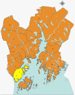
Kristiansand Region is a statistical metropolitan region in the counties of Vest-Agder and Aust-Agder in southern Norway. It is centered on the city of Kristiansand. The region consist of 6 municipalities in the centre of Southern Norway. Vennesla, Songdalen, and Birkenes are inland municipalities while Kristiansand, Søgne, and Lillesand are coastal municipalities. Kristiansand is the largest municipality in population in the region and Birkeland is the largest in area.

Southern Norway is the geographical region (landsdel) along the Skagerrak coast of southern Norway. The region is an informal description since it does not have any governmental function. It roughly corresponds to the old petty kingdom of Agder as well as the two present-day counties of Vest-Agder and Aust-Agder. The total combined area of Vest-Agder and Aust-Agder counties is 16,493 square kilometres (6,368 sq mi). The name is relatively new, having first been used in Norway around 1900.

Randesund is a village and district within the city of Kristiansand in Vest-Agder county, Norway. The district is located within the borough of Oddernes along the southern coastline between Kvåsefjorden and the Topdalsfjorden and south of the districts of Søm and Hånes. There are several small islands that are just off the coast in Randesund, including Dvergsøya, Randøya, and Herøya, all popular tourists destinations. The village of Randesund is located in the central part of the district and it is the site of Randesund Church. There was a separate municipality of Randesund that existed from 1893 until 1965.

Norwegian National Road 41 is a Norwegian national road that runs through Telemark, Aust-Agder, and Vest-Agder counties in Norway. The road runs between the village of Brunkeberg in Kviteseid municipality in Telemark county in the north and Timenes in Hånes in the city of Kristiansand in Vest-Agder county in the south. The 172.9-kilometre (107.4 mi) long road connects to the European route E134 highway in the north and to the European route E18 highway in the south. The road runs for 12.5 kilometres (7.8 mi) in Vest-Agder county, 89 kilometres (55 mi) in Aust-Agder county, and 71.4 kilometres (44.4 mi) in Telemark county. The southern half of the road runs along the river Tovdalselva and the lake Herefossfjorden, and it is located in a fault zone called the Kristiansand-Porsgrunn grabenen.

Kvadraturen is the city center of Kristiansand in Vest-Agder county, Norway, with a population of 6,750 (2015). The borough is made up of the centre together with the harbour to the south and the more rural district of "Eg" to the north. Kvadraturen is the administrative centre of the municipality of Kristiansand as well as the administrative centre of Vest-Agder county, but is far smaller in area than the other boroughs in the municipality, such as the borough of Grim to the north and west, and the borough of Lund to the east.

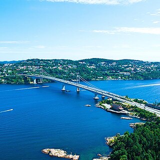
Hånes is a district in the city of Kristiansand in Vest-Agder county, Norway. It has a population of about 4,000 (2014). Hånes is a part of the borough of Oddernes and it borders the districts of Søm and Randesund to south, the district of Tveit to north, the municipality of Lillesand to east, and the Topdalsfjorden to west. Hånes Church is located in this district.

Søm is a district in the city of Kristiansand in Vest-Agder county, Norway. With a population of about 9,000 (2014), it is the third largest district in Kristiansand. The district is a part of the borough of Oddernes. Søm has borders with the district of Hånes to the north, the district of Randesund to the east and south, and the Topdalsfjorden to the west. Søm is the second most wealthy district in Kristiansand after Lund. Søm Church is located in the district.
Lauvåsen is a neighbourhood in the city of Kristiansand in Vest-Agder county, Norway. It is a part of the borough of Oddernes and it is in the district of Hånes. The neighbourhood lies between European route E18 and Norwegian National Road 41, just east of the neighborhood of Hånni and southeast of the neighborhood of Grovikheia.

Gimle is a neighbourhood in the city of Kristiansand in Vest-Agder county, Norway. It's located in the borough of Lund. It is located near the neighborhoods of Oddemarka and Presteheia. The neighborhood of Kjøita lies to the southwest and the neighborhood of Marvika lies to the southeast.

Frikstad is a neighbourhood in the city of Kristiansand in Vest-Agder county, Norway. It's located in the borough of Oddernes and in the district of Randesund. Randesund Church is located at Frikstad. The neighborhoods of Holte and Tømmerstø lie to the southwest and the neighborhood of Kongshavn lies to the southeast.
Gislemyr is a neighbourhood in the city of Kristiansand in Vest-Agder county, Norway. It is located in the borough of Vågsbygd and in the district of Slettheia. Gislemyr is north of Karuss, and south of Trane, and west of Blørstad and Fiskåtangen.
Trane or Rugde is a neighbourhood in the city of Kristiansand in Vest-Agder county, Norway. It is located in the northern part of the borough of Vågsbygd and in the district of Slettheia. Trane/Rugde is northwest of Gislemyr, north of Nedre Slettheia, south of Rige, and east of Øvre Slettheia.

Hamresanden is a 3-kilometre (1.9 mi) long beach in the municipality of Kristiansand in Vest-Agder county, Norway. The sandy beach is located at Hamre in the district of Tveit, along the Topdalsfjorden at the mouth of the river Topdalselva. It is located near Kristiansand Airport, Kjevik. Hamresanden goes from Grovikheia in Hånes to Ve.

Gillsvannet or Gjelsvannet is a freshwater lake in the municipality of Kristiansand in Vest-Agder county, Norway. The 1.05-square-kilometre (260-acre) lake is located about 5 kilometres (3.1 mi) northeast of downtown Kristiansand, along to County Road 452. The lake lies about 300 metres (980 ft) west of the Topdalsfjorden, at an elevation of about 1 metre above sea level. There is a practice range for kayaking on the lake as well as many areas used for swimming during the summer season. The Gimlekollen district lies on the southern shore of the lake and the village of Justvik lies just north of the lake.
Oddernes is a former municipality in Vest-Agder county, Norway. The 103-square-kilometre (40 sq mi) municipality existed from 1838 until its dissolution in 1964. The administrative centre was the village of Lund on the east side of the river Otra near where Lund Church is located. The former area of the municipality makes up the western part of the municipality of Kristiansand. It encircled the town of Kristiansand, and it included the villages such as Flekkerøy, Vågsbygd, Slettheia, Lund, Strai, Mosby, and Justvik. Today, the town of Kristiansand has a borough named Oddernes, but it has very different boundaries than the old municipality had.

Hånes Church is a parish church in Kristiansand municipality in Vest-Agder county, Norway. It is located in the district of Hånes in the borough of Oddernes in the eastern part of the city of Kristiansand. The church is part of the Hånes parish in the Kristiansand arch-deanery in the Diocese of Agder og Telemark. The white, stone/brick church was built in 1986 using plans by the architect Arild Lauvland. The church seats about 300 people.