Ben Nevis is the highest mountain in the British Isles. Standing at 1,345 metres (4,411 ft) above sea level, it is at the western end of the Grampian Mountains in the Lochaber area of the Scottish Highlands, close to the town of Fort William.

The Cordillera Huayhuash is a mountain range within the Andes of Peru, in the boundaries of the regions of Ancash, Lima and Huánuco. Since 2002 it is protected within the Cordillera Huayhuash Reserved Zone.

Mount Brandon or Brandon at 952 metres (3,123 ft), is the 8th–highest peak in Ireland on the Arderin scale, and the 9th–highest according to the Vandeleur-Lynam scale. Brandon is the highest Irish peak outside of the MacGillycuddy's Reeks range, and has the greatest prominence of any Irish peak except Carrauntoohil, Ireland's highest mountain. Brandon is named after Saint Brendan and is the end of a Christian pilgrimage trail known as Cosán na Naomh. Brandon is at the centre of the Brandon Group of mountains in the Dingle Peninsula in Kerry.

The High Tauern are a mountain range on the main chain of the Central Eastern Alps, comprising the highest peaks east of the Brenner Pass. The crest forms the southern border of the Austrian states of Salzburg, Carinthia and East Tyrol, with a small part in the southwest belongs to the Italian province of South Tyrol. The range includes Austria's highest mountain, the Grossglockner at 3,798 metres (12,461 ft) above the Adriatic.

Grosses Fiescherhorn is a mountain peak of the Bernese Alps, located on the border between the cantons of Bern and ValaisValais, halfway between the Mönch and the Finsteraarhorn. At 4,049 metres (13,284 ft) above sea level, its summit culminates over the whole Fiescherhorn massif, which is also composed of the slightly lower Hinteres Fiescherhorn to the south and Kleines Fiescherhorn to the east. From the north both are well hidden behind other mountain peaks and can only been seen from Isch in Grindelwald. The mountain is shared between the municipalities of Grindelwald and Fieschertal.
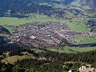
Oberstdorf is a municipality and skiing and hiking town in southwest Germany, located in the Allgäu region of the Bavarian Alps. Oberstdorf is one of the highest market towns in Germany. The southernmost point in Germany is located in the municipality and it is the southernmost settlement in both Bavaria, and in Germany overall.

The Großer Priel is, at 2,515 metres above the Adriatic (8,251 ft), the highest mountain of the Totes Gebirge range, located in the Traunviertel region of Upper Austria. It ranks among the ultra prominent peaks of the Alps. Part of the Northern Limestone Alps, its steep Dachstein cliffs form the northeastern rim of a large karst plateau and are visible from afar across the Alpine Foreland.
Løkjelsvatnet or Lykilsvatnet is a regulated lake in the municipality of Etne in Hordaland county, Norway. The 4.51-square-kilometre (1.74 sq mi) lake lies about 10 kilometres (6.2 mi) east of the village of Etnesjøen. Water from the lake falls 400 metres (1,300 ft) vertically in tunnels and pipelines to the Hardeland hydroelectric power station. The site is operated by Haugaland Kraft.

Purple Mountain at 832 metres (2,730 ft) high, is the 21st–highest peak in Ireland on the Arderin scale, and the 28th–highest according to the Vandeleur-Lynam scale. Purple mountain is the highest peak of the Purple Mountain Group, and is located in County Kerry, Ireland.

The Gross Lohner, is a limestone mountain of the Bernese Alps, located between Adelboden and Kandersteg in the Bernese Oberland. The main summit has an elevation of 3,048.7 metres (10,002 ft) above sea level and is distinguished by the name Vorder Lohner. The mountain features several other peaks, from east to west:

The Mittagstein is a 1,034-metre-high (3,392 ft) mountain peak which rises in the middle of the Kaitersberg in the Bavarian Forest in southern Germany.

The Großer Knollen is a 687.4-metre-high (2,255 ft) mountain in the southwestern part of the Harz in Lower Saxony, Germany.
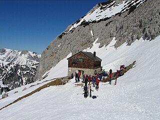
The Fritz Pflaum Hut is an Alpine club hut belonging to the Bayerland Section of the German Alpine Club, located in the Kaisergebirge mountains in the Austrian federal state of Tyrol.

Two-thousanders are mountains that have a height of at least 2,000 metres above sea level, but less than 3,000 metres. The term is used in Alpine circles, especially in Europe.
The Fritzerkogel is a mountain in the Tennengebirge in the northern Limestone Alps, Austria. With its elevation of 2,360 metres (7,740 ft), is one of the higher peaks in the mountain range. Seen from the north it stands out as a relatively isolated, broad summit block, whose mighty rock faces and steep, rugged, rocky flanks (Schrofen) fall away on all sides. Its 1,200-metre-high (3,900 ft) south cliff face is impressive and makes it a striking two-thousander.

Caher West Top at 973.4 metres (3,194 ft), is the fifth-highest peak in Ireland on the Irish Vandeleur-Lynam classification, and part of the MacGillycuddy's Reeks range. Caher West Top is the only Furth to have a prominence below 30 metres (98 ft).