Gryllefjord
| |
|---|---|
Village | |
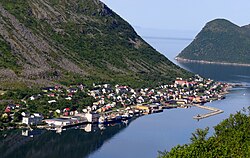 View of the village | |
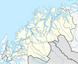
 Interactive map of Gryllefjord | |
 Gryllefjord  Gryllefjord | |
| Coordinates: 69°21′46″N17°03′10″E / 69.36278°N 17.05278°E | |
| Country | Norway |
| Region | Northern Norway |
| County | Troms |
| District | Midt-Troms |
| Municipality | Senja Municipality |
| Area | |
• Total | 0.25 km2 (0.097 sq mi) |
| Elevation | 3 m (9.8 ft) |
| Population (2023) [1] | |
• Total | 325 |
| • Density | 1,300/km2 (3,400/sq mi) |
| Time zone | UTC+01:00 (CET) |
| • Summer (DST) | UTC+02:00 (CEST) |
| Post Code | 9380 Gryllefjord |
Gryllefjord (Norwegian) or Grullefierda (Northern Sami) [3] is a fishing village in Senja Municipality in Troms county, Norway. It is located on the island of Senja, along the Gryllefjorden in the northern part of the municipality. The 0.25-square-kilometre (62-acre) village has a population (2023) of 325 and a population density of 1,300 inhabitants per square kilometre (3,400/sq mi). [1]
The Andenes–Gryllefjord Ferry, is a car ferry service that runs during the summer to Andenes on the island of Andøya. The village is connected by road to the village of Torsken, about 4 kilometres (2.5 mi) south, and to the town of Finnsnes, about 60 kilometres (37 mi) east.
The village was the administrative centre of the old Torsken Municipality which existed until 1 January 2020 when it was merged into Senja Municipality.
There is one nursing home in the village (as of 2021). [4]
