
The Río de la Plata —rendered River Plate in British English and the Commonwealth and La Plata River in other English-speaking countries—is the estuary formed by the confluence of the Uruguay and the Paraná rivers. It empties into the Atlantic Ocean, forming a funnel-shaped indentation on the southeastern coastline of South America. Depending on the geographer, the Río de la Plata may be considered a river, an estuary, a gulf or a marginal sea. For those who consider it a river, it is the widest river in the world, with a maximum width of about 220 kilometres (140 mi).
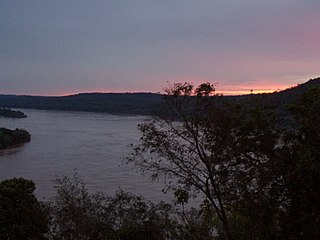
The Uruguay River is a river in South America. It flows from north to south and forms parts of the boundaries of Brazil, Argentina, and Uruguay, separating some of the Argentine provinces of La Mesopotamia from the other two countries. It passes between the states of Santa Catarina and Rio Grande do Sul in Brazil; forms the eastern border of the provinces of Misiones, Corrientes, and Entre Ríos in Argentina; and makes up the western borders of the departments of Artigas, Salto, Paysandú, Río Negro, Soriano, and Colonia in Uruguay.

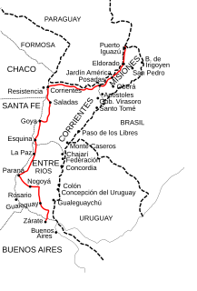
The Paraná River is a river in south Central South America, running through Brazil, Paraguay, and Argentina for some 4,880 kilometres (3,030 mi). It is second in length only to the Amazon River among South American rivers. The name Paraná is an abbreviation of the phrase "para rehe onáva", which comes from the Tupi language and means "like the sea". It merges first with the Paraguay River and then farther downstream with the Uruguay River to form the Río de la Plata and empties into the Atlantic Ocean.
Gualeguay is a city in the province of Entre Ríos, Argentina, on the Gualeguay River, about 226 km from the provincial capital Paraná and 234 km north-west from Buenos Aires. It has a population of about 39,000 inhabitants as per the 2001 census [INDEC]. It should not be confused with Gualeguaychú.
The Saladillo Stream is a small tributary of the Paraná River, that discharges into it between the cities of Rosario and Villa Gobernador Gálvez, in the province of Santa Fe, Argentina. It serves as the political border between these two towns of the Greater Rosario area, and is one of the two important affluents of the Paraná in the area, together with the Ludueña Stream in the north.
The Salado River is a river that crosses several provinces of Argentina, flowing 1,150 kilometres (710 mi) from its source in the Salta Province to end in the Paraná River, in the Santa Fe Province. Because its origin, its flow varies widely within the year, and it can dry out in some parts of its path during the winter. The only important tributary to the river is the Horcones River, which is born in Salta as Cajón River, and joins the Salado in the Santiago del Estero Province.

Villaguay is a city in the province of Entre Ríos in the Argentine Mesopotamia. It has about 49,000 inhabitants as of the census 2010 and is the head town of the department of the same name.
The Carcarañá River is a river in Argentina. It begins at the confluence of the Río Tercero and the Saladillo River in the south-east of the province of Córdoba and flows eastward into the province of Santa Fe, which it crosses.

The Ibicuy Islands are a maze of low-level islands in the east of the Paraná Delta, within Entre Ríos Province, Argentina. They are located between the Paraná and Uruguay Rivers. The islands are part of the Islas del Ibicuy Department and have scattered but important settlements, like their capital Villa Paranacito. The principal access is by the Ibicuy River, a branch of the Paraná River.
The Gualeguaychú River is a river in the province of Entre Ríos, Argentina. It starts in the center-east of the province, within the Colón Department, and flows south, passing by the city of Gualeguaychú and then emptying into the Uruguay River. Its drainage basin has an area of 6,693 square kilometres (2,584 sq mi).
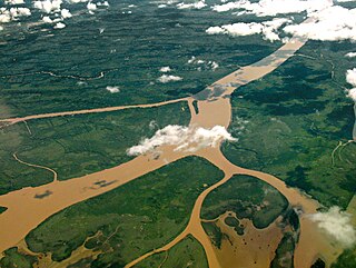
The Paraná Delta is the delta of the Paraná River in Argentina and it consists of several islands known as the Islas del Paraná. The Paraná flows north–south and becomes an alluvial basin between the Argentine provinces of Entre Ríos, Santa Fe and Buenos Aires then emptying into the Río de la Plata.
The Guayquiraró River is a river in the Mesopotamic northeastern region of Argentina. It is born in the middle section of the border between the provinces of Entre Ríos and Corrientes, fed from several streams on its right-hand basin. It flows west along the interprovincial border for about 110 kilometres (68 mi), then emptying into the Paraná River, at a base level of about 26 metres (85 ft) AMSL.
The Feliciano River is a river in the Argentine province of Entre Ríos, in the Mesopotamia. It is born on the Lomada del Mocoretá, on the northeast of the province, east of San José de Feliciano, and flows west-southwest across the province. Its course receives the waters of several streams, and after 198 kilometres (123 mi) it empties into the Paraná River near Piedras Blancas.
The San Javier River is an anabranch of the Paraná River in the province of Santa Fe, Argentina.
National Route 12 (RN12) is a road in Argentina, connecting the northeast section to the rest of the country. It runs through the provinces of Misiones, Corrientes, Entre Ríos and Buenos Aires.
The Litoral region of Argentina underwent heavy rainstorms in the early autumn season of 2007. Starting in late March and ending in mid-April, the rains caused several major rivers to rise and/or overflow their banks, partly or completely flooded many towns and large cities, ruined a significant part of the crops in a wide region, and severely damaged the physical infrastructure. At least 15 people were killed as a result of the flooding.

The Entre Ríos Railway (ERR) was a British-owned railway company that built and operated a 1,435 mmstandard gauge railway network in Entre Ríos Province, between the rivers Uruguay and Paraná, in Argentina.

The Central Entre Ríos Railway (CERR) was a railway company in the Entre Ríos Province of Argentina, owned by the provincial government, which built and operated a 1,435 mmstandard gauge railway network between the rivers Paraná and Uruguay. In 1892 it was sold to the British–owned Entre Ríos Railway.


