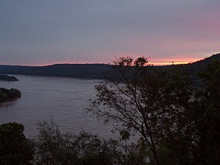
The Uruguay River is a river in South America. It flows from north to south and forms parts of the boundaries of Brazil, Argentina, and Uruguay, separating some of the Argentine provinces of La Mesopotamia from the other two countries. It passes between the states of Santa Catarina and Rio Grande do Sul in Brazil; forms the eastern border of the provinces of Misiones, Corrientes, and Entre Ríos in Argentina; and makes up the western borders of the departments of Artigas, Salto, Paysandú, Río Negro, Soriano, and Colonia in Uruguay.
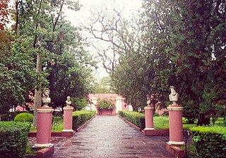
The San José Palace is the former personal residence of Justo José de Urquiza, Argentine caudillo, general, politician and President of the Argentine Confederation from 1854 to 1860. The Palace is now the setting of the Justo José de Urquiza Museum and National Monument.
Gualeguay is a city in the province of Entre Ríos, Argentina, on the Gualeguay River, about 226 km from the provincial capital Paraná and 234 km north-west from Buenos Aires. It has a population of about 39,000 inhabitants as per the 2001 census [INDEC]. It should not be confused with Gualeguaychú.

Gualeguaychú is a city in the province of Entre Ríos, Argentina, on the left bank of the Gualeguaychú River. It is located on the south-east of the province, approximately 230 km north-west of Buenos Aires. It has a population of 109,266 according to the 2010 Census.

The Zárate–Brazo Largo Bridges are two cable-stayed road and railway bridges in Argentina, crossing the Paraná River between the cities of Zárate, Buenos Aires Province, and Brazo Largo, Entre Ríos Province.
The pulp mill dispute was a dispute between Argentina and Uruguay concerning the construction of pulp mills on the Uruguay River. The presidents at the time were Néstor Kirchner (Argentina) and Tabaré Vázquez (Uruguay). As a diplomatic, economic, and public relations conflict between both parties, the dispute also affected tourism and transportation as well as the otherwise amicable relations between the two countries. The feud was unprecedented between the two countries, which have shared historical and cultural ties. Proceedings were brought before the International Court of Justice as a case formally named Pulp Mills on the River Uruguay (Argentina v. Uruguay). It ruled that, although Uruguay failed to inform Argentina of the operations, it did not pollute the river, so closing the pulp mill would be unjustified. The conflict ended in 2010, during the presidencies of Cristina Fernández de Kirchner (Argentina) and José Mujica (Uruguay), with the establishment of a joint coordination of the activities in the river.
The Libertador General San Martín Bridge is a cantilever road bridge that crosses the Uruguay River and joins Argentina and Uruguay. It runs between Puerto Unzué, near Gualeguaychú, Entre Ríos Province, Argentina, and Fray Bentos, Río Negro Department, Uruguay, with a total length of 5,966 meters (3.7 mi).
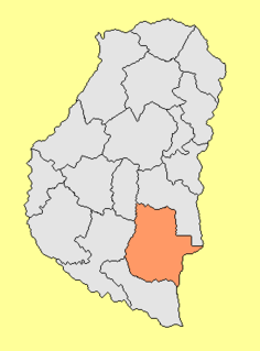
The Gualeguaychú Department is an administrative subdivision (departamento) of the province of Entre Ríos, Argentina. It is located in the south-east of the province, beside the Uruguay River.
Gualeguaychú may refer to:

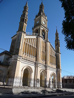
The Roman Catholic Diocese of Gualeguaychú is a Latin suffragan bishopric in the ecclesiastical province of the Metropolitan Archdiocese of Paraná in Entre Ríos Province, eastern-central Argentina.
Club Deportivo Juventud Unida is an Argentine sports club. The football team currently plays in the Torneo Federal A, the third level of the Argentine football league system.

The Central Entre Ríos Railway (CERR) was a railway company in the Entre Ríos Province of Argentina, owned by the provincial government, which built and operated a 1,435 mmstandard gauge railway network between the rivers Paraná and Uruguay. In 1892 it was sold to the British–owned Entre Ríos Railway.

Aldea San Antonio is a village in the department of Gualeguaychu, in Entre Ríos Province, Argentina. The village was founded on February 27, 1889, by immigrant Volga German families from the village of Splavnukha (Huck), to the west of the Volga river in Saratov Oblast, in Russia.

Larroque (Argentina) is a city in the Entre Ríos Province, in north-eastern Argentina. It is located on the South of the province, between Gualeguay and Gualeguaychú. It has a population of 6,451 according to the 2010 Census.
Las Moscas is a village and municipality in Entre Ríos Province in north-eastern Argentina.
Pastor Britos is a village and municipality in Entre Ríos Province in north-eastern Argentina. It is a place and rural population center governing board 4th category of Pehuajó Gualeguaychú North district department in the province of Entre Rios, Argentina. It is 45 km northwest of the city of Gualeguaychú, 8 km from Urdinarrain and 192 km of Paraná. The town grew around a train station, now defunct. Town was not considered in the censuses of 1991 and 2001 so that the population was surveyed as a dispersed rural area without precisar.2 3 One of the popular events that take place regularly, is a pilgrimage from the town of Urdinarrain to the grotto located in Pastor Britos. It is connected by Route 51, with the towns of Urdinarrain, Parera, Irazusta, Larroque and E. Carbo. And another way you can get from Gualeguaychú through Palavecino, Almada and Parera.4 5 Dr. Scholein Rivenson, inventor of the vaccine for foot and mouth disease was born in Pastor Britos. The Governing Board was created by Decree 2434/1988 MGJOSP 26 May 1988.6 In the 2011 elections the 5 vowels of the governing board elected at common polling Faustino M. Parera, including it in their jurisdiction. Because there was a tie, the election was repeated
Puntas del Gualeguaychú is a village and municipality in Entre Ríos Province in north-eastern Argentina.


