
Route 66 is a state highway located in Monmouth County, New Jersey, United States. It runs 3.62 mi (5.83 km) between Route 33 in Tinton Falls and Route 35 at County Route 16 on the border of Ocean Township and Neptune Township, just to the west of Asbury Park. The route serves as an important connector between the Garden State Parkway to the west and Route 18 and Asbury Park to the east. It runs concurrent with County Route 16 from Bowne/Wayside Roads to the eastern terminus at Route 35. Route 66, which varies from a two-lane undivided road to a four-lane divided highway, passes through commercial areas for most of its length with some wooded areas. The route was created in 1953, replacing what had been Route 33-35 Link. There is currently a proposal to widen the two-lane portion between Jumping Brook Road and Wayside Road in order to better handle the traffic that uses this road.
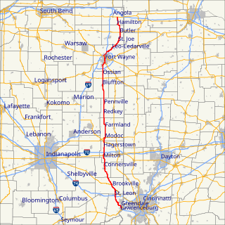
State Road 1 is a north–south state highway in the eastern portion of the U.S. state of Indiana. Its southern terminus is at U.S. Highway 50 in east-central Dearborn County, just east of Lawrenceburg. Its northern terminus is at U.S. Highway 20 in east-central Steuben County, approximately six miles east of Angola.

U.S. Route 50 is a major east–west route of the U.S. Highway system, stretching just over 3,000 miles (4,800 km) from Ocean City, Maryland on the Atlantic Ocean to West Sacramento, California. In the U.S. state of Maryland, US 50 exists in two sections. The longer of these serves as a major route connecting Washington, D.C. with Ocean City; the latter is the eastern terminus of the highway. The other section passes through the southern end of Garrett County for less than 10 miles (16 km) as part of the Northwestern Turnpike, entering West Virginia at both ends. One notable section of US 50 is the dual-span Chesapeake Bay Bridge across the Chesapeake Bay, which links the Baltimore–Washington metropolitan area with the Eastern Shore region, allowing motorists to reach Ocean City and the Delaware Beaches.

Pennsylvania Route 987 is a state highway in the U.S. state of Pennsylvania, running 10.3 mi (16.6 km) from U.S. Route 22 near the Lehigh Valley International Airport north of Allentown north to PA 946 in Klecknersville. The route begins at a cloverleaf interchange with the US 22 freeway north of Allentown in Lehigh County and heads to the east of the airport as a four-lane divided highway called Airport Road as it crosses into Northampton County. PA 987 narrows to a two-lane undivided road and continues north, becoming concurrent with PA 329 as it heads into Bath. Here, PA 329 ends and PA 987 briefly runs concurrent with PA 248 before leaving the borough. PA 987 continues northwest and serves Chapman before ending at PA 946. PA 987 was first designated in the 1930s between US 22 in Allentown and PA 946 in Klecknersville. After US 22 was relocated to its present freeway alignment in 1955, the southern terminus of PA 987 was cut back to its interchange with US 22, which used to carry Interstate 78 (I-78) as well. In the early 2000s, PA 987 was widened into a divided highway and shifted to a new alignment near the Lehigh Valley International Airport.

State Highway 85 or SH 85 is a state highway in the U.S. state of Texas that runs almost 77 miles (124 km) from Carrizo Springs to Charlotte.
U.S. Route 13 is a north–south U.S. highway established in 1926 that runs for 517 miles (832 km) from Interstate 95 just north of Fayetteville, North Carolina to U.S. Route 1 in Falls Township, Pennsylvania, a northeastern suburb of Philadelphia. In the U.S. state of Virginia, US 13 runs north–south through the Hampton Roads and Eastern Shore regions of the state, using the Chesapeake Bay Bridge–Tunnel to get between the two. In the Hampton Roads area, it uses Military Highway to bypass the city centers. It is most usually a four-lane highway, sometimes up to freeway or expressway standards with controlled access.

Pennsylvania Route 150 is a 41.1-mile-long (66.1 km) highway in Central Pennsylvania. Its northern terminus is at U.S. Route 220 in Avis, Pennsylvania. Its southern terminus is at Pennsylvania Route 26 in Dale Summit, Pennsylvania near State College, at the location of the Nittany Mall.
State Route 279 (SR-279) is a 9-mile-long (14 km) state highway in Jackson County.

Guam Highway 1 (GH-1), also known as Marine Corps Drive, is one of the primary automobile routes in the United States territory of Guam. It runs in a southwest-to-northeast direction, from the main gate of Naval Base Guam in the western community of Santa Rita in a general northeasterly direction to the main gate of Andersen Air Force Base in the community of Yigo. It passes through Guam's capital, Hagåtña, as well as intersecting various other territorial highways. Along its route, the highway runs through tropical forest areas, urbanized commercial areas, and residential neighborhoods. The US Military built the road starting in 1941. Construction ceased with the Japanese invasion in December 1941 and resumed in 1944. The highway was formally dedicated to the US Marines by the territorial governor in 2004.
U.S. Route 60 (US 60) is an east–west United States Highway within Arizona. The highway runs for 369 miles (594 km) from a junction with Interstate 10 near Quartzsite to the New Mexico State Line near Springerville. As it crosses the state, US 60 overlaps at various points: I-17, I-10, SR 77, SR 260, US 191, and US 180. Between Wickenburg and Phoenix, the route is known as Grand Avenue. From Tempe to Apache Junction, it is known as the Superstition Freeway.

Pennsylvania Route 136 is a 40-mile-long (64 km) state highway located in Washington, Allegheny, and Westmoreland Counties in Pennsylvania. The western terminus is at US 40 & PA 18 in Washington. The eastern terminus is at US 30 in Greensburg.

Pennsylvania Route 315 is an 8.2-mile-long (13.2 km) state highway located in Luzerne County, Pennsylvania. The southern terminus is at an interchange with the PA 309 freeway in Wilkes-Barre. The northern terminus is at the entrance of the Wilkes-Barre/Scranton International Airport in Pittston Township just past an interchange with Interstate 81 (I-81). PA 315 heads northeast from PA 309 as a multilane road through suburban development in the Wyoming Valley parallel to I-81. The route comes to an interchange with I-81 and I-476 before passing through Dupont along a one-way pair. Past here, PA 315 follows a divided highway to I-81 and the airport.

U.S. Route 220 is a U.S. Highway that runs from Rockingham, North Carolina north to South Waverly, Pennsylvania. In the state of Pennsylvania, the route runs 248 miles (399 km) from the Maryland border in Cumberland Valley Township, Bedford County northeast to an interchange with Interstate 86 (I-86)/New York State Route 17 in South Waverly, Bradford County a short distance south of the New York border. Through the state, US 220 passes through the cities and towns of Bedford, Altoona, State College, Lock Haven, Williamsport, and Towanda. US 220 is concurrent with the entire completed Pennsylvania segment of I-99 between I-70/I-76 in Bedford and I-80 near Bellefonte. US 220 is also a freeway around Bedford, along the I-80 concurrency between Bellefonte and Mill Hall, between Mill Hall and Jersey Shore, from the western end of Williamsport to near Halls, and near the New York border. The remainder of US 220 in Pennsylvania is mostly a two-lane surface road.
Guam Highway 3 (GH-3) is one of the primary automobile highways in the United States territory of Guam.
Guam Highway 9 (GH-9) is one of the primary automobile highways in the United States territory of Guam.
Guam Highway 10A (GH-10A) is one of the primary automobile highways in the United States territory of Guam.
Guam Highway 15 (GH-15) is one of the primary automobile highways in the United States territory of Guam.
Guam Highway 14 (GH-14) is one of the primary automobile highways in the United States territory of Guam.
Guam Highway 27 (GH-27), also known as Hamburger Highway or Harmon Loop Road, is a short highway in the United States territory of Guam. The highway runs in an east–west direction from a junction with GH-16 to a junction with GH-1, and is located almost entirely in the southern region of the city of Dededo. The highway gets its name from the fact that it provides access to a large McDonald's restaurant located at the intersection with GH-16.


