Tamuning, Guam

Last updated
Tamuning
Tamuneng
St. Anthony Catholic Church (Guam).JPG
Locator maps of Guam villages - Tamuning.svg
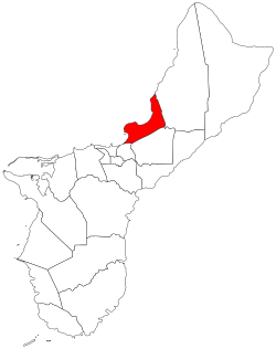
Location of Tamuning within the Territory of Guam
Coordinates: 13°29′02″N144°46′36″E / 13.48389°N 144.77667°E / 13.48389; 144.77667
Country United States
Territory Guam
Government
   Mayor Louise C. Rivera (R)
   Vice Mayor Albert M. Toves (R)
Population
 (2020) [1]
  Total18,489
Time zone UTC+10 (ChST)

Tamuning, also known as Tamuning-Tumon-Harmon (Chamorro: Tamuneng) is a village located on the western shore of the United States territory of Guam. The village of Tamuning is the economic center of Guam, containing tourist center Tumon, Harmon Industrial Park, and other commercial districts. Its central location along Marine Corps Drive, the island's main thoroughfare, has aided in its development.

Contents

Historical population
CensusPop.Note
1960 5,944
1970 10,21871.9%
1980 13,58032.9%
1990 16,67322.8%
2000 18,0128.0%
2010 19,6859.3%
2020 18,489−6.1%
Source: [1]

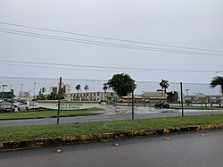
Tamuning is the site of the access roads and the old passenger terminal of Antonio B. Won Pat International Airport, the passenger airport for Guam. [2] Fort Juan Muña, in Harmon, is a facility for the Guam Army National Guard.

The present and former locations of Guam Memorial Hospital, Guam's only civilian and government operated hospital, are in Tamuning. With Guam's only private birthing center [3] also in the village, most modern civilian births on Guam take place in Tamuning.

Etymology

Houses of Carolininans, possibly in Tamuning, in 1899 or 1900 Caroline Islanders Village near Agana, Guam (1899-1900).jpg
Houses of Carolininans, possibly in Tamuning, in 1899 or 1900

The ancient Chamorro word for Tamuning was Apurgan or Apotgan. "Tamuning" is a Carolinian word that was given to the area where Carolinians settled after an earthquake on January 25, 1849, near Guam caused a tsunami that devastated Lamotrek and Satawal. It is possibly the name of the clan of a Carolinian chief, though the American administration relocated the Carolinians to Saipan in the early 1900s. The area was also called Maria Christina in the 19th century. [4]

Geography

The Federal government of the United States owns portions of the land in Tamuning; the Government of Guam stated that it was one of several villages that are "characterized primarily by the large proportion of land owned by the federal government". [5]

Economy

Antonio B. Won Pat International Airport old terminal - Continental Micronesia headquarters Guam International Airport Old Terminal Building2.JPG
Antonio B. Won Pat International Airport old terminal - Continental Micronesia headquarters

Beside the tourist district of Tumon, Tamuning is home to the Guam Premier Outlets, one of three major shopping centers of the island. United Airlines is headquartered in the old terminal building at Antonio B. Won Pat International Airport in Tamuning. [6] [7] United Airlines, with about 1,400 jobs, is Guam's largest single employer. [8]

As of January 2024, Tamuning is home to one of only six Kmart stores left worldwide. [9]

Demographics

The U.S. Census Bureau has the municipality in multiple census-designated places: Tamuning, [10] Apotgan, [11] Harmon Industrial Park, [12] Oka, [13] Tumon, [14] and Upper Tumon. [15]

Infrastructure and government

Government of Guam

The Guam Department of Land Management and the Guam Economic Development Authority have their headquarters in the Guam International Trade Center (ITC) Building in Tamuning. [16] [17]

The Guam Power Authority has its headquarters in Harmon, Tamuning. [18]

The Guam Department of Mental Health and Substance Abuse has its main facility in Tamuning, across from Guam Memorial Hospital. [19] [20]

U.S. federal government

The United States Postal Service operates the Tamuning Post Office at 143 Edward T. Calvo Memorial Parkway. [21]

Climate

Under the Köppen climate classification, Tamuning features a tropical rainforest climate. While the town does experience a noticeably drier season from February through April, it does not have a true dry season as all months average more than 60 mm (2.4 in) of precipitation. Tamuning averages roughly 2,300 mm (91 in) of precipitation annually, while maintaining relatively consistent temperatures throughout the course of the year.

Climate data for Tamuning, Guam
MonthJanFebMarAprMayJunJulAugSepOctNovDecYear
Mean daily maximum °F (°C)85.1
(29.5)
85.3
(29.6)
86.1
(30.1)
87.0
(30.6)
87.4
(30.8)
87.8
(31.0)
87.2
(30.7)
86.9
(30.5)
86.9
(30.5)
87.1
(30.6)
86.8
(30.4)
85.9
(29.9)
86.6
(30.3)
Mean daily minimum °F (°C)75.1
(23.9)
74.6
(23.7)
75.0
(23.9)
76.2
(24.6)
76.9
(24.9)
77.1
(25.1)
76.5
(24.7)
76.2
(24.6)
76.1
(24.5)
76.4
(24.7)
76.7
(24.8)
76.1
(24.5)
76.1
(24.5)
Average precipitation inches (mm)4.5
(110)
3.5
(89)
2.6
(66)
3.3
(84)
5.0
(130)
6.3
(160)
10.4
(260)
14.4
(370)
13.4
(340)
12.2
(310)
8.4
(210)
5.5
(140)
89.5
(2,270)
Source: Weatherbase [22]

Education

Path alongside coastal fortifications from the Japanese occupation of Guam Road to Marriott from Ypao Beach Park - panoramio.jpg
Path alongside coastal fortifications from the Japanese occupation of Guam

Primary and secondary schools

Public schools

John F. Kennedy High School John F. Kennedy High School (Guam).jpg
John F. Kennedy High School

Guam Public School System serves the island.

Public schools serving Tamuning: [23]

  • Chief Brodie Memorial Elementary School (Tamuning)
  • Lyndon B. Johnson Elementary School (Tamuning)
  • Tamuning Elementary School (Tamuning)
  • Jose L. G. Rios Middle School (Piti)
  • John F. Kennedy High School (Tamuning)

In regards to the Department of Defense Education Activity (DoDEA), Tamuning is in the school transportation zone for Andersen Elementary and Andersen Middle School, while Guam High School is the island's sole DoDEA high school. [24]

Private schools

Diplomacy

The Guam International Trade Center (ITC) building at the southwest corner of Marine Corps Drive (Route 1) and Chalan San Antonio (Route 14) Guam ITC building.JPG
The Guam International Trade Center (ITC) building at the southwest corner of Marine Corps Drive (Route 1) and Chalan San Antonio (Route 14)

Five countries maintain consulates in Tamuning, [25] four of which are located in the landmark Guam ITC building at 590 South Marine Corps Drive. [26] [27] [28] [29] They are:

Government

Guam Memorial Hospital Guam Memorial Hospital.JPG
Guam Memorial Hospital
View of Tumon from Two Lovers Point Two Lovers Point - panoramio.jpg
View of Tumon from Two Lovers Point
Commissioner of Tamuning
NameTerm beginTerm end
Simon A. Sanchez19461948
Jose P. Castro19481957
Eugenio I. San Nicolas19571963
Gregorio A. Calvo19651973
Mayor of Tamuning
NamePartyTerm beginTerm end
Gregorio A. Calvo Republican January 1, 1973January 7, 1985
Alfredo C. Dungca Democratic January 7, 1985January 6, 1997
Luis S.N. HerreroJanuary 6, 1997January 1, 2001
Concepcion "Connie" DuenasRepublicanJanuary 1, 2001January 3, 2005
Francisco "Frank" C. BlasJanuary 3, 2005January 7, 2013
Louise C. RiveraJanuary 7, 2013present
Vice Mayor of Tamuning
NamePartyTerm beginTerm end
Maria S.N. Leon Guerrero Republican January 1, 1973January 3, 1977
Alfredo C. DungcaJanuary 3, 1977January 7, 1985
Peter S. Calvo Democratic January 7, 1985January 2, 1989
Teresita C. BorjaJanuary 2, 1989January 6, 1997
Concepcion M. DuenasRepublicanJanuary 6, 1997January 1, 2001
Nancy Leon GuerreroJanuary 1, 2001January 3, 2005
Louise C. RiveraJanuary 3, 2005January 7, 2013
Kenneth C. SantosJanuary 7, 2013October 30, 2020
Office vacant October 30, 2020 – January 4, 2021
Albert M. TovesRepublicanJanuary 4, 2021present

Notable people

See also

Related Research Articles

<span class="mw-page-title-main">Hagåtña, Guam</span> Capital city of Guam

Hagåtña is the capital village of the United States territory of Guam. From the 18th through mid-20th century, it was Guam's population center, but today it is the second smallest of the island's 19 villages in both area and population. However, it remains one of the island's major commercial districts in addition to being the seat of government.

<span class="mw-page-title-main">Tumon, Guam</span> District of Guam

Tumon is a district located on Tumon Bay along the northwest coast of the United States unincorporated territory of Guam. Located in the municipality of Tamuning, it is the center of Guam's tourist industry.

<span class="mw-page-title-main">Asan-Maina, Guam</span> Village in Guam, United States

Asan-Maina is a village located on the western shore of the United States territory of Guam. The municipality combines the names of the coastal community of Asan with Maina, a community along the slopes of the Fonte River valley to the east. Asan was the northern landing site for United States Marines during Guam's liberation from the Japanese during World War II. Asan Beach Park is part of the War in the Pacific National Historic Park. The third community comprising Asan-Maina is Nimitz Hill Annex in the hills above Asan and Maina, which is the location of the Joint Region Marianas headquarters. Asan-Maina is located in the Luchan (Western) District.

<span class="mw-page-title-main">Yona, Guam</span> Village in Guam, United States

Yona is a village in the United States territory of Guam.

<span class="mw-page-title-main">Agana Heights, Guam</span> Village in Guam, United States

Agana Heights is one of the nineteen villages in the United States territory of Guam. It is located in the hills south of Hagåtña, in the central part of the island. United States Naval Hospital Guam is located in this largely residential village.

The Guam Department of Education (GDOE), formerly the Guam Public School System, is a school district that serves the United States territory of Guam. The school district can be thought of as analogous to the school districts of other cities and communities in the United States, but in some manners, it can also be thought of as analogous to the state education agencies of other states and territories.

<span class="mw-page-title-main">Mongmong-Toto-Maite, Guam</span> Village in Guam, United States

Mongmong-Toto-Maite is a municipality in the United States territory of Guam composed of three separate villages east of Hagåtña that experienced development after the Second World War.

<span class="mw-page-title-main">Guam Highway 1</span> Highway in Guam

Guam Highway 1 (GH-1), also known as Marine Corps Drive, is one of the primary automobile routes in the United States territory of Guam. It runs in a southwest-to-northeast direction, from the main gate of Naval Base Guam in the southwestern village of Santa Rita in a northeasterly direction to the main gate of Andersen Air Force Base in the village of Yigo. It passes through Guam's capital, Hagåtña, as well as intersecting other territorial highways. The highway runs through tropical forest, urbanized commercial areas, and residential neighborhoods. The US military upgraded and extended the road starting in 1941. Construction ceased with the Japanese invasion in December 1941 and resumed after the Second Battle of Guam in 1944. The highway was formally dedicated to the U.S. Marine Corps by the governor in 2004.

The Guam Department of Corrections is an agency of the government of the United States territory of Guam that operates the island's correctional facilities.

Guam Highway 14 (GH-14) is one of the primary automobile highways in the United States territory of Guam.

<span class="mw-page-title-main">Guam Department of Land Management</span>

The Guam Department of Land Management is a department of the government on the United States territory of Guam. The department has its headquarters in the Guam International Trade Center (ITC) Building in Tamuning.

<span class="mw-page-title-main">Talo'fo'fo, Guam</span> Village in Guam, United States

Talo'fo'fo, formerly Talofofo, is a village located in the southern part of the United States territory of Guam, on the east coast. The village center is located in the hills above the coast, while the smaller coastal community below the cliff is known as Ipan.

<span class="mw-page-title-main">Inalåhan, Guam</span> Village in Guam, United States

Inalåhan is a village located on the southeastern coast of the United States territory of Guam. The village's original Chamoru name, Inalåhan, was altered when transliterated during Spanish control of the island.

<span class="mw-page-title-main">Dededo</span> Village in Guam, United States

Dededo is the most populated village in the United States territory of Guam. According to the U.S. Census Bureau, Dededo's population was just under 45,000 in 2020. The village is located on the coral plateau of Northern Guam. The greater Dededo-Machanao-Apotgan Urban Cluster had a population of 139,825 as of the 2010 census, making up 87.7% of Guam's population and 29.8% of its area.

<span class="mw-page-title-main">Yigo, Guam</span> Village in Guam, United States

Yigo, Guam is the northernmost village of the United States territory of Guam, and is the location of Andersen Air Force Base. The municipality of Yigo is the largest village on the island in terms of area. It contains a number of populated places, including Asatdas and Agafo Gumas.

<span class="mw-page-title-main">Chalan Pago-Ordot, Guam</span> Village in Guam, United States

Chalan Pago-Ordot is a village in the United States territory of Guam, containing the communities of Chalan Pago and Ordot. It is located in the eastern-central part of the island and is part of the Kattan (Eastern) District. The village's population has increased slightly since the island's 2010 census.

<span class="mw-page-title-main">Barrigada, Guam</span> Village in Guam, United States

Barrigada is a village in the United States territory of Guam. A largely residential municipality, its main village is located south of the Antonio B. Won Pat International Airport near the intersections of Routes 8, 10, and 16. The community east of the airport known as Barrigada Heights is considered an affluent neighborhood on the island, where homes have excellent views overlooking much of Guam including the island's airport and hotels along Tumon Bay. Another significant location is Mount Barrigada, nearly 200 meters above sea level. Its location in the center of the island means it houses most of the island's radio masts and towers; the position and height make it easier for radio signals to reach the entire island.

<span class="mw-page-title-main">Malesso, Guam</span> Village in Guam, United States

Malesso' is the southernmost village in the United States territory of Guam. Cocos Island is a part of the municipality. The village's population has decreased since the island's 2010 census.

<span class="mw-page-title-main">Mangilao, Guam</span> Village in Guam, United States

Mangilao is a village on the eastern shore of the United States territory of Guam. The village's population has decreased slightly since the island's 2010 census.

<span class="mw-page-title-main">Japanese School of Guam</span> Primary & middle school in Mangilao, Guam, United States

The Japanese School of Guam is a Japanese international school in Mangilao, Guam. It includes both day school and weekend supplementary school divisions, and the school also holds Japanese language classes. As of April 2013 Toyohito Yoneyama is the chairperson of the school.

References

  1. 1 2 Population of Guam: 2010 and 2020, U.S. Census Bureau.
  2. "CBC66010_009.pdf." U.S. Census Bureau. Retrieved on October 6, 2010.
  3. http://guambuildupnews.com/Details/SAGUA-MANAGU.html
  4. "Tamuning-Tumon-Harmon (Tamuneng-Tomhom)". Guampedia. October 2009. Retrieved 20 May 2020.
  5. "North and Central Guam Land Use Plan" (PDF). Government of Guam Bureau of Statistics and Plans. September 2009. pp. 2–8 (PDF p. 24/64). Retrieved 2023-07-04.
  6. "Docket No. SDWA-06-2005-1516." United States Environmental Protection Agency . Retrieved on February 5, 2009.
  7. Letter Archived 2012-03-09 at the Wayback Machine . United States Department of Transportation Office of Aviation Enforcement and Proceedings. May 23, 1997. Retrieved on October 4, 2010. "Continental Micronesia Old Terminal Bldg. P.O. Box 8778-G Tamuning, GU 96931-8778."
  8. Kerrigan, Kevin. "Guam Will Be The Pacific Hub for Merged Airlines." Pacific News Center. Wednesday May 5, 2010. Retrieved on October 5, 2010. "Continental Micronesia is Guam's single largest employer. About 14-hundred jobs here on dependant on the airline."
  9. Last recorded reliable source quoted the total number of Kmart stores globally as seven, after the planned closure of West St. Croix. This report is from June 2023:

    The West St. Croix store was confirmed closed on June 5, 2023: "Kmart West is Closing; Mall Owner Says Redevelopment Plan Will Provide 'First Rate Center'". The Virgin Islands Consortium. 8 June 2023. Retrieved 22 January 2024.

  10. "2010 CENSUS - CENSUS BLOCK MAP: Tamuning CDP, GU" (PDF). U.S. Census Bureau . Retrieved 2020-10-09. - See "Tamuning muny"
  11. "2010 CENSUS - CENSUS BLOCK MAP: Apotgan CDP, GU" (PDF). U.S. Census Bureau . Retrieved 2020-10-09.
  12. "2010 CENSUS - CENSUS BLOCK MAP: Harmon Industrial Park CDP, GU" (PDF). U.S. Census Bureau . Retrieved 2020-10-09.
  13. "2010 CENSUS - CENSUS BLOCK MAP: Oka CDP, GU" (PDF). U.S. Census Bureau . Retrieved 2020-10-09.
  14. "2010 CENSUS - CENSUS BLOCK MAP (INDEX): Tumon CDP, GU" (PDF). U.S. Census Bureau . Retrieved 2020-10-09. - 1 and 2, and 3.
  15. "2010 CENSUS - CENSUS BLOCK MAP: Upper Tumon CDP, GU" (PDF). U.S. Census Bureau . Retrieved 2020-10-09.
  16. "DLM%20Contact%20Info.pdf Archived 2011-07-21 at the Wayback Machine ." Guam Department of Land Management. Retrieved on October 21, 2010. "Street Address: 590 S. Marine Corps Drive Suite 733, ITC Building, Tamuning, GU 96913"
  17. "GEDA Guam – Invest In Guam".
  18. "Grants and Resources." Environmental Protection Agency. Retrieved on October 13, 2010. "1911 Route 16 Harmon, GU 96911."
  19. "About DMHSA Archived 2010-09-25 at the Wayback Machine ." Guam Department of Mental Health and Substance Abuse. Retrieved on October 21, 2010.
  20. "Facilities Archived 2010-07-28 at the Wayback Machine ." Guam Department of Mental Health and Substance Abuse. Retrieved on October 21, 2010. "DMHSA Facility ( Click here to view Location Map ) Location : 790 Gov. Camacho Road, Tamuning, Guam 96913." Map Archived 2011-07-21 at the Wayback Machine .
  21. "Post Office Location - TAMUNING." United States Postal Service . Retrieved on December 4, 2008.
  22. "Weatherbase: Historical Weather for Tamuning, Guam". Weatherbase. 2011. Retrieved on November 24, 2011.
  23. "筋トレ豆知識 | 筋トレ豆知識". www.lk4kids.com. Archived from the original on 22 February 2006. Retrieved 12 January 2022.
  24. "DoDEA Guam School Boundaries and Bus Transportation Zones". Military Morale, Welfare and Recreation Guam. Retrieved 2023-07-07.
  25. "Largest & Most Trusted Listing in Guam". Guam Phone Book.
  26. 1 2 "Federated States of Micronesia Consulates in the USA." Embassy of the Federated States of Micronesia, Washington, DC . Retrieved on December 4, 2008.
  27. 1 2 Home page. Consulate-General of Japan in Hagatna . Retrieved on December 4, 2008.
  28. 1 2 "Palau - U.S. Consulates and Overseas Missions." Embassy of the Republic of Palau, Washington, DC . Retrieved on December 4, 2008.
  29. 1 2 Home page. Consulate-General of the Philippines in Agana, Guam . Retrieved on December 4, 2008.
  30. "총영사관 소개." Embassy of the Republic of Korea in the United States of America . Retrieved on December 4, 2008.