Guam is a U.S. territory in the western Pacific Ocean, at the boundary of the Philippine Sea. It is the southernmost and largest member of the Mariana Islands archipelago, which is itself the northernmost group of islands in Micronesia. The closest political entity is the Commonwealth of the Northern Mariana Islands (CNMI), another U.S. territory. Guam shares maritime boundaries with CNMI to the north and the Federated States of Micronesia to the south. It is located approximately one quarter of the way from the Philippines to Hawaii. Its location and size make it strategically important. It is the only island with both a protected harbor and land for multiple airports between Asia and Hawaii, on an east–west axis, and between Papua New Guinea and Japan, on a north–south axis.

Apra Harbor, also called Port Apra, is a deep-water port on the western side of the United States territory of Guam. It is considered one of the best natural ports in the Pacific Ocean. The harbor is bounded by Cabras Island and the Glass Breakwater to the north and the Orote Peninsula in the south. Naval Base Guam and the Port of Guam are the two major users of the harbor. It is also a popular recreation area for boaters, surfers, scuba divers, and other recreationalists.

The Roman Catholic Archdiocese of Agaña is an ecclesiastical territory or diocese of the Catholic Church in the United States. It comprises the United States dependency of Guam. The prelate is an archbishop whose cathedral is the Dulce Nombre de Maria Cathedral-Basilica.

Piti is a village located on the central west coast of the United States territory of Guam. It contains northern and eastern coastlines of Apra Harbor, including Cabras Island, which has the commercial Port of Guam and the island's largest power plants. Piti was a pre-Spanish CHamoru village and, after Spanish colonization, became the primary port town on Guam. The town was largely destroyed during the 1944 liberation of Guam and the population relocated during the wartime construction of Apra Harbor.

The War in the Pacific National Historical Park is a multi-unit protected area in the United States territory of Guam, which was established in 1978 in honor of those who participated in the Pacific Theater of World War II. Uniquely among the National Park System, it honors the bravery and sacrifices of all those who participated in the Pacific Theater.
The Guam Department of Education (GDOE), formerly the Guam Public School System, is a school district that serves the United States territory of Guam. The school district can be thought of as analogous to the school districts of other cities and communities in the United States, but in some manners, it can also be thought of as analogous to the state education agencies of other states and territories.

Guam Highway 1 (GH-1), also known as Marine Corps Drive, is one of the primary automobile routes in the United States territory of Guam. It runs in a southwest-to-northeast direction, from the main gate of Naval Base Guam in the southwestern village of Santa Rita in a northeasterly direction to the main gate of Andersen Air Force Base in the village of Yigo. It passes through Guam's capital, Hagåtña, as well as intersecting other territorial highways. The highway runs through tropical forest, urbanized commercial areas, and residential neighborhoods. The US military upgraded and extended the road starting in 1941. Construction ceased with the Japanese invasion in December 1941 and resumed after the Second Battle of Guam in 1944. The highway was formally dedicated to the U.S. Marine Corps by the governor in 2004.
The area code 671 is the local telephone area code of the United States territory of Guam. It was created with the beginning of permissive dialing on July 1, 1997, replacing Guam's previous International Telecommunication Union country code 671 at the end of permissive dialing on July 1, 1998.

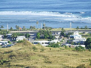
Nimitz Hill Annex is a community and census-designated place (CDP) in Asan-Maina, Guam. It contains the geographic feature of Nimitz Hill, and is located immediately northeast of the Nimitz Hill CDP in Piti. In normal conversation, the Nimitz Hill CDP and Nimitz Hill Annex CDP are often collectively referred to as "Nimitz Hill."

The postage stamps and postal history of Guam is an overview of the postage stamps and postal history of the United States territory of Guam. Its postal service is linked to those of the Philippines during the Spanish Empire and, since 1898, to the United States of America. A peculiarity is that, for a short period in the 1930s, Guam had a local post service.
Guam Highway 4 (GH-4) is one of the primary automobile highways in the United States territory of Guam.
Southern High School is a public secondary school located at 1 Jose Perez Leon Guerrero Drive in the village of Santa Rita, in the United States territory of Guam. The school, a part of the Guam Public School System, opened in 1997 and serves grades 9 through 12. Southern High serves the villages of Santa Rita, Agat, Asan-Maina, Inarajan, Merizo, Piti, Talofofo, Umatac, and Yona.

Agat Bay is a bay on the west coast of Guam. Its northern boundary is the Orote Peninsula, occupied entirely by Naval Base Guam, which itself lies within the village of Sånta Rita-Sumai. The bay stretches south along the coast of the village of Hågat to Facpi Point. With a length of some seven kilometers, the bay stretches for nearly one fifth of the west coast of Guam. The Asan Invasion Beach of the 1944 Battle of Guam is commemorated by the Agat Unit of War in the Pacific National Historical Park, which spans surce and subsurface areas from Apaca Point to Bangi Point. The NRHP-listed Agat World War II Amtrac is submerged off Agat Cemetery.
The Guam Department of Parks and Recreation operates public parks in Guam. The agency has its headquarters in Agana Heights.
Joint Region Marianas' mission is to provide installation management support to all Department of Defense components and tenants through assigned regional installations on Guam and the Northern Mariana Islands in support of training in the Marianas; to act as the interface between the Department of Defense and the civilian community; to ensure compliance with all environmental laws and regulations, safety procedures, and equal opportunity policy; and perform other functions and tasks as may be assigned.
10th Independent Mixed Regiment was a regiment of the Imperial Japanese Army that has association with a number of U.S. National Register of Historic Places-listed places in Guam.

Piti Bomb Holes Marine Preserve is a marine protected area comprising all of Piti Bay on the western coast of Guam, located off of the village of Piti in the Philippine Sea. The defining "bomb hole" features, named because they look like bomb craters in the reef flat, are actually natural percolation pits where fresh water filters into the shallow lagoon at a depth of 25 to 30 feet. The largest pit houses the commercial Fish Eye Marine Park tourist attraction, which includes a wooden pier to a underwater observatory and a Seawalker tour of the lagoon bottom. It is visited by more than 200,000 people annually. The Piti preserve is the most ecologically diverse of Guam's five marine preserves. The pit around Fish Eye is a popular snorkeling and recreational diving site.
Asan is a community and census-designated place (CDP) along the western coast of the U.S. territory of Guam. Asan, along with Maina and Nimitz Hill Annex, are the three communities in the village of Asan-Maina. It is known for being the location of northern invasion beach used by the United States during the retaking of Guam in 1944.