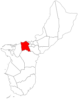
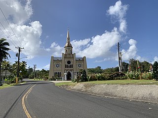
Asan-Maina, Guam

Last updated
Asan-Maina
Assan-Ma'ina
Locator maps of Guam villages - Asan-Maina.svg
Location of Asan-Maina within the Territory of Guam.
Country United States
Territory Guam
Government
   Mayor Frank A. Salas (D)
Population
 (2020) [1]
  Total2,011
   Ethnic groups
Chamorro
Time zone UTC+10 (ChST)
Village  Flower Plumeria rubra

Asan-Maina (Chamorro : Assan-Ma'ina) is a village located on the western shore of the United States territory of Guam. The municipality combines the names of the coastal community of Asan with Maina, a community along the slopes of the Fonte River valley to the east. Asan was the northern landing site for United States Marines during Guam's liberation from the Japanese during World War II. Asan Beach Park is part of the War in the Pacific National Historic Park. The third community comprising Asan-Maina is Nimitz Hill Annex in the hills above Asan and Maina, which is the location of the Joint Region Marianas headquarters. Asan-Maina is located in the Luchan (Western) District.

Contents

Etymology

Asan derives its name from the Chamorro word hassan meaning scarce or rare.

One meaning of the word ma’ina refers to an infant who, between the time of birth and baptism, is taken by the mother to Mass before sunrise. This old ritual was considered analogous to and in imitation of the Presentation of Jesus in the Temple.

History

On July 21, 1944, the Americans landed in Asan to recapture the island from occupying Japanese forces during the Battle of Guam. The 3rd Marine Division landed in Asan at 08:28, and the 1st Provisional Marine Brigade landed near Agat to the south. Japanese artillery sank 20 Landing Vehicle Trackeds, but by 09:00 tanks were ashore at both beaches. United States Marines fought Japanese forces fortified in the hills above the shore after establishing a beach head. During the following week, Americans pursued retreating Japanese forces northward and eventually won the battle.[ citation needed ]

From April to November 1975 the former Camp Asan was used as a refugee camp for South Vietnamese refugees during Operation New Life. [2]

On August 6, 1997, Korean Air Flight 801 crashed east of Nimitz Hill Annex in Asan. A memorial was later constructed. [3] [4]

Demographics

Historical population
CensusPop.Note
1960 3,053
1970 2,629−13.9%
1980 2,034−22.6%
1990 2,0701.8%
2000 2,0901.0%
2010 2,1372.2%
2020 2,011−5.9%
Source: [1]

The U.S. Census Bureau counts the following census-designated places in Asan-Maina: Asan, [5] Maina, [6] and Nimitz Hill Annex. [7]

Education

Guam Public School System serves the island. Southern High School in Santa Rita serves the village. [8]

In regards to the Department of Defense Education Activity (DoDEA), Asan is in the school transportation zone for McCool Elementary and McCool Middle School, while Guam High School is the island's sole DoDEA high school. [9]

Parks and recreation

Every year the island's largest Easter egg hunt is at the War in the Pacific National Park with over 10,000 eggs. The village also hosts the yearly International Kite Flying Competitions with people from South Korea, Japan, China, Guam, and the Northern Mariana Islands competing for the championship.

Government

View of the Asan Beach Unit of War in the Pacific National Historical Park and buildings in Asan from the highlands of Nimitz Hill Annex View of Asan Park (cropped).jpg
View of the Asan Beach Unit of War in the Pacific National Historical Park and buildings in Asan from the highlands of Nimitz Hill Annex
Commissioner of Asan-Maina
NameTerm beginTerm end
Enrique S. Cruz19271931
Santiago A. Limtiaco (1st term)19311938
Joaquin L. Jesus19381941
Santiago A. Limtiaco (2nd term)19441957
Joaquin S. Santos1957January 1, 1973
Mayor of Asan-Maina
NamePartyTerm beginTerm end
Jose S. Quitugua Democratic January 1. 1973January 5, 1981
Daniel L. GuerreroJanuary 5, 1981January 7, 1985
Frank A. Acfalle Republican January 7, 1985January 2, 1989
Vicente L. San NicolasDemocraticJanuary 2, 1989January 7, 2013
Joana Margaret C. BlasRepublicanJanuary 7, 2013January 2, 2017
Frank "Frankie" A. SalasDemocraticJanuary 2, 2017present

See also

Related Research Articles

<span class="mw-page-title-main">Hagåtña, Guam</span> Capital city of Guam

Hagåtña is the capital village of the United States territory of Guam. From the 18th through mid-20th century, it was Guam's population center, but today it is the second smallest of the island's 19 villages in both area and population. However, it remains one of the island's major commercial districts in addition to being the seat of government.

<span class="mw-page-title-main">Tamuning, Guam</span> Village in Guam, United States

Tamuning, also known as Tamuning-Tumon-Harmon is a village located on the western shore of the United States territory of Guam. The village of Tamuning is the economic center of Guam, containing tourist center Tumon, Harmon Industrial Park, and other commercial districts. Its central location along Marine Corps Drive, the island's main thoroughfare, has aided in its development.

<span class="mw-page-title-main">Hågat, Guam</span> Village in Guam, United States

Hågat is a village in the United States territory of Guam. It is located south of Apra Harbor on the island's western shore. The village's population has decreased since the island's 2010 census.

<span class="mw-page-title-main">Sånta Rita-Sumai, Guam</span> Village in Guam, United States

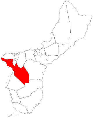
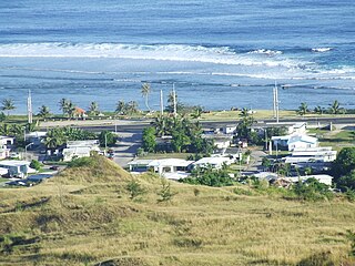
Sånta Rita-Sumai, formerly Santa Rita and encompassing the former municipality of Sumay, is a village located on the southwest coast of the United States territory of Guam with hills overlooking Apra Harbor. According to the 2020 census it has a population of 6,470, which is up slightly from 6,084 in 2010 but down from 11,857 in 1990. Santa Rita is the newest village in Guam, having been established after the Second World War.

<span class="mw-page-title-main">Piti, Guam</span> Village in Guam, United States

Piti is a village located on the central west coast of the United States territory of Guam. It contains northern and eastern coastlines of Apra Harbor, including Cabras Island, which has the commercial Port of Guam and the island's largest power plants. Piti was a pre-Spanish CHamoru village and, after Spanish colonization, became the primary port town on Guam. The town was largely destroyed during the 1944 liberation of Guam and the population relocated during the wartime construction of Apra Harbor.

<span class="mw-page-title-main">Yona, Guam</span> Village in Guam, United States

Yona is a village in the United States territory of Guam.

<span class="mw-page-title-main">War in the Pacific National Historical Park</span> National Historical Park of the United States

The War in the Pacific National Historical Park is a multi-unit protected area in the United States territory of Guam, which was established in 1978 in honor of those who participated in the Pacific Theater of World War II. Uniquely among the National Park System, it honors the bravery and sacrifices of all those who participated in the Pacific Theater.

<span class="mw-page-title-main">Agana Heights, Guam</span> Village in Guam, United States

Agana Heights is one of the nineteen villages in the United States territory of Guam. It is located in the hills south of Hagåtña, in the central part of the island. United States Naval Hospital Guam is located in this largely residential village.

<span class="mw-page-title-main">Sinajana, Guam</span> Village in Guam, United States

Sinajana is the smallest of the nineteen villages in the United States territory of Guam by area. It is located in the hills south of Hagåtña. The village's name may have come from the word "china-jan," cookware used to cook wild yams that once grew in the area.

<span class="mw-page-title-main">Mongmong-Toto-Maite, Guam</span> Village in Guam, United States

Mongmong-Toto-Maite is a municipality in the United States territory of Guam composed of three separate villages east of Hagåtña that experienced development after the Second World War.

<span class="mw-page-title-main">Nimitz Hill Annex</span> Census-designated place in Guam, United States

Nimitz Hill Annex is a community and census-designated place (CDP) in Asan-Maina, Guam. It contains the geographic feature of Nimitz Hill, and is located immediately northeast of the Nimitz Hill CDP in Piti. In normal conversation, the Nimitz Hill CDP and Nimitz Hill Annex CDP are often collectively referred to as "Nimitz Hill."

<span class="mw-page-title-main">Talo'fo'fo, Guam</span> Village in Guam, United States

Talo'fo'fo, formerly Talofofo, is a village located in the southern part of the United States territory of Guam, on the east coast. The village center is located in the hills above the coast, while the smaller coastal community below the cliff is known as Ipan.

<span class="mw-page-title-main">Inalåhan, Guam</span> Village in Guam, United States

Inalåhan is a village located on the southeastern coast of the United States territory of Guam. The village's original Chamoru name, Inalåhan, was altered when transliterated during Spanish control of the island.

<span class="mw-page-title-main">Dededo</span> Village in Guam, United States

Dededo is the most populated village in the United States territory of Guam. According to the U.S. Census Bureau, Dededo's population was just under 45,000 in 2020. The village is located on the coral plateau of Northern Guam. The greater Dededo-Machanao-Apotgan Urban Cluster had a population of 139,825 as of the 2010 census, making up 87.7% of Guam's population and 29.8% of its area.

<span class="mw-page-title-main">Yigo, Guam</span> Village in Guam, United States

Yigo, Guam is the northernmost village of the United States territory of Guam, and is the location of Andersen Air Force Base. The municipality of Yigo is the largest village on the island in terms of area. It contains a number of populated places, including Asatdas and Agafo Gumas.

<span class="mw-page-title-main">Chalan Pago-Ordot, Guam</span> Village in Guam, United States

Chalan Pago-Ordot is a village in the United States territory of Guam, containing the communities of Chalan Pago and Ordot. It is located in the eastern-central part of the island and is part of the Kattan (Eastern) District. The village's population has increased slightly since the island's 2010 census.

<span class="mw-page-title-main">Malesso, Guam</span> Village in Guam, United States

Malesso' is the southernmost village in the United States territory of Guam. Cocos Island is a part of the municipality. The village's population has decreased since the island's 2010 census.

<span class="mw-page-title-main">Mangilao, Guam</span> Village in Guam, United States

Mangilao is a village on the eastern shore of the United States territory of Guam. The village's population has decreased slightly since the island's 2010 census.

<span class="mw-page-title-main">Asan, Guam</span> Census-designated place in Guam, United States

Asan is a community and census-designated place (CDP) along the western coast of the U.S. territory of Guam. Asan, along with Maina and Nimitz Hill Annex, are the three communities in the village of Asan-Maina. It is known for being the location of northern invasion beach used by the United States during the retaking of Guam in 1944.

<span class="mw-page-title-main">Nimitz Hill (geographic feature)</span>

References

  1. 1 2 Population of Guam: 2010 and 2020, U.S. Census Bureau.
  2. Dunham, George R (1990). U.S. Marines in Vietnam: The Bitter End, 1973–1975 (Marine Corps Vietnam Operational Historical Series). History and Museums Division Headquarters, U.S. Marine Corps. pp. 222–6. ISBN   9780160264559.
  3. "Korean Air Flt 801 - Official Guam Crash Site Information Web Center". Archived from the original on 2004-08-06.
  4. "CBC66010_008.pdf." U.S. Census Bureau. Retrieved on September 19, 2009.
  5. "2010 CENSUS - CENSUS BLOCK MAP: Asan CDP, GU" (PDF). U.S. Census Bureau . Retrieved 2020-10-09. - See "Asan muny"
  6. "2010 CENSUS - CENSUS BLOCK MAP: Maina CDP, GU" (PDF). U.S. Census Bureau . Retrieved 2020-10-09. - See "Asan muny"
  7. "2010 CENSUS - CENSUS BLOCK MAP: Nimitz Hill Annex CDP, GU" (PDF). U.S. Census Bureau . Retrieved 2020-10-09. - See "Asan muny"
  8. "Guam's Public High Schools Archived 2006-05-19 at the Wayback Machine ." Guam Public School System. Accessed September 8, 2008.
  9. "DoDEA Guam School Boundaries and Bus Transportation Zones". Military Morale, Welfare and Recreation Guam. Retrieved 2023-07-07.

13°28′17″N144°42′50″E / 13.47139°N 144.71389°E / 13.47139; 144.71389