Related Research Articles
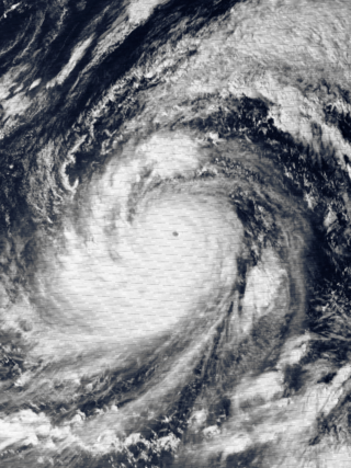
Typhoon Tip, known in the Philippines as Typhoon Warling, was the largest and most intense tropical cyclone ever recorded. The forty-third tropical depression, nineteenth tropical storm, twelfth typhoon, and third super typhoon of the 1979 Pacific typhoon season, Tip developed out of a disturbance within the monsoon trough on October 4 near Pohnpei in Micronesia. Initially, Tropical Storm Roger to the northwest hindered the development and motion of Tip, though after the storm tracked farther north, Tip was able to intensify. After passing Guam, Tip rapidly intensified and reached peak sustained winds of 305 km/h (190 mph) and a worldwide record-low sea-level pressure of 870 hPa (25.69 inHg) on October 12. At its peak intensity, Tip was the largest tropical cyclone on record, with a wind diameter of 2,220 km (1,380 mi). Tip slowly weakened as it continued west-northwestward and later turned to the northeast, in response to an approaching trough. The typhoon made landfall in southern Japan on October 19, and became an extratropical cyclone shortly thereafter. Tip's extratropical remnants continued moving east-northeastward, until they dissipated near the Aleutian Islands on October 24.
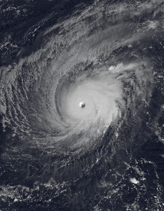
Typhoon Paka, known in the Philippines as Typhoon Rubing, was the last tropical cyclone of the 1997 Pacific hurricane and typhoon season, and was among the strongest Pacific typhoons in the month of December. Paka, which is the Hawaiian name for Pat, developed on November 28 from a trough well to the southwest of Hawaii. The storm tracked generally westward for much of its duration, and on December 7 it crossed into the western Pacific Ocean. Much of its track was characterized by fluctuations in intensity, and on December 10 the cyclone attained typhoon status as it crossed the Marshall Islands. On December 16, Paka struck Guam and Rota with winds of 230 km/h (140 mph), and it strengthened further to reach peak winds on December 18 over open waters as the final super typhoon of the year. Subsequently, it underwent a steady weakening trend, and on December 23 Paka dissipated.

The 1997 Pacific hurricane season was a very active hurricane season. With hundreds of deaths and hundreds of millions of dollars in damage, this season was one of the costliest and deadliest Pacific hurricane seasons. This was due to the exceptionally strong 1997–98 El Niño event. The season officially started on May 15, in the eastern Pacific, and on June 1, in the central Pacific, and lasted until November 30. These dates conventionally delimit the period of each year when almost all tropical cyclones form in the northeastern Pacific Ocean.

The 1997 Pacific typhoon season was a record-breaking season featuring 11 tropical cyclones reaching super typhoon intensity, tying the record with 1965 with the most violent tropical cyclones globally. It has no official bounds; it ran year-round in 1997, but most tropical cyclones tend to form in the northwestern Pacific Ocean between May and November. These dates conventionally delimit the period of each year when most tropical cyclones form in the northwestern Pacific Ocean.

The 1989 Pacific typhoon season was a highly above-average season. It has no official bounds; it ran year-round in 1989, but most tropical cyclones tend to form in the northwestern Pacific Ocean between May and November. These dates conventionally delimit the period of each year when most tropical cyclones form in the northwestern Pacific Ocean. Tropical Storms forming in the Western Pacific basin were assigned a name by the Joint Typhoon Warning Center. Tropical depressions that enter or form in the Philippine area of responsibility are assigned a name by the Philippine Atmospheric, Geophysical and Astronomical Services Administration or PAGASA. This can often result in the same storm having two names.

Typhoon Pongsona was the last typhoon of the 2002 Pacific typhoon season, and was the second costliest United States disaster in 2002, only behind Hurricane Lili. The name "Pongsona" was contributed by North Korea for the Pacific tropical cyclone list and is the Korean name for the garden balsam. Pongsona developed out of an area of disturbed weather on December 2, and steadily intensified to reach typhoon status on December 5. On December 8 it passed through Guam and the Northern Mariana Islands while near its peak winds of 175 km/h (109 mph) 10-min). It ultimately turned to the northeast, weakened, and became extratropical on December 11. Typhoon Pongsona produced strong wind gusts peaking at 290 km/h (180 mph) 1-min), which left the entire island of Guam without power and destroyed about 1,300 houses. With strong building standards and experience from repeated typhoon strikes, there were no fatalities directly related to Pongsona, although there was one indirect death from flying glass. Damage on the island totaled over $730 million, making Pongsona among the five costliest typhoons on the island. The typhoon also caused extreme damage on Rota and elsewhere in the Northern Mariana Islands, and as a result of its impact the name was retired.

The 1964 Pacific typhoon season was the most active tropical cyclone season recorded globally, with a total of 39 tropical storms forming. It had no official bounds; it ran year-round in 1964, but most tropical cyclones tend to form in the northwestern Pacific Ocean between June and December. These dates conventionally delimit the period of each year when most tropical cyclones form in the northwestern Pacific Ocean.

The 1963 Pacific typhoon season has no official bounds; it ran year-round in 1963, but most tropical cyclones tend to form in the northwestern Pacific Ocean between June and December. These dates conventionally delimit the period of each year when most tropical cyclones form in the northwestern Pacific Ocean.
Typhoon Omar of 1992, known in the Philippines as Typhoon Lusing, was the strongest and costliest typhoon to strike Guam since Typhoon Pamela in 1976. The cyclone formed on August 23 from the monsoon trough across the western Pacific Ocean. Moving westward, Omar slowly intensified into a tropical storm, although another tropical cyclone nearby initially impeded further strengthening. After the two storms became more distant, Omar quickly strengthened into a powerful typhoon. On August 28, it made landfall on Guam with winds of 195 km/h (120 mph). The typhoon reached its peak intensity the next day, with estimated 1‑minute winds of 240 km/h (150 mph), making it a "super typhoon" according to the Joint Typhoon Warning Center (JTWC). Omar weakened significantly before striking eastern Taiwan on September 4, proceeding into eastern China the next day and dissipating on September 9.

The 1951 Pacific typhoon season was a generally below average season with multiple tropical cyclones striking the Philippines. With the exception of January, each month saw at least one tropical system develop; October was the most active month with four tropical cyclones forming. Overall, there were 21 tropical depressions, of which 17 became named storms; of those, there were 16 typhoons.

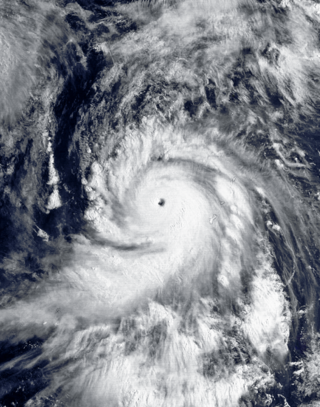
Typhoon Karen was the most powerful tropical cyclone to strike the island of Guam, and has been regarded as one of the most destructive events in the island's history. It was first identified as a tropical disturbance on November 6, 1962, well to the southeast of Truk. Over the following two days, the system tracked generally northward and quickly intensified. Karen became a tropical storm late on November 7, and within two days it explosively intensified into a Category 5-equivalent super typhoon on the Saffir–Simpson scale. Turning westward, the typhoon maintained its intensity and struck Guam with winds of 280 km/h (170 mph) on November 11. Once clear of the island, it strengthened slightly and reached its peak intensity on November 13 with winds of 295 km/h (183 mph) and a barometric pressure of 894 mb. The storm then gradually turned northward as it weakened, brushing the Ryukyu Islands on November 15, before moving east-northeastward over the open waters of the Pacific. Karen continued to weaken and transitioned into an extratropical cyclone on November 17 before losing its identity the following day between Alaska and Hawaii.
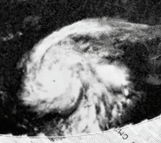
Typhoon Pamela was a powerful typhoon that struck the U.S. territory of Guam in May 1976, causing about $500 million in damage (USD). The sixth named storm and third typhoon of the 1976 Pacific typhoon season, Pamela developed on May 14 from a trough in the Federated States of Micronesia in the area of the Nomoi Islands. It executed a counterclockwise loop and slowly intensified, bringing heavy rains to the islands in the region. Ten people died on Chuuk due to a landslide. After beginning a steady northwest motion toward Guam, Pamela attained its peak winds of 240 km/h (150 mph).

Typhoon Joan was an intense typhoon that caused minor damages in relative to the strength of the typhoon. Joan was the strongest typhoon of 1959 Pacific typhoon season, and one of the most intense Pacific typhoons on record. Joan formed from a surface center to the northeast of Guam on August 23, in which Japan Meteorological Agency began to track and classify the system as a tropical depression on the next day. A reconnaissance aircraft was sent to investigate the surface center and in 03:25 UTC on August 25 the surface center was classified as a tropical storm by Joint Typhoon Warning Center. The storm rapidly intensified into a typhoon in the same day it was formed. By the next three days as Joan tracks towards Taiwan, Joan explosively intensified to attain peak intensity with the pressure of 885 millibars (26.1 inHg), which is tied with Nina as the most intense Pacific typhoon on the record at the time. Shortly afterwards, Joan attained peak strength as a Category 5 equivalent typhoon on the Saffir–Simpson hurricane scale with winds of 165 knots (190 mph) before making landfall in Taiwan as a 160 knots (180 mph) typhoon, which was according to JTWC is the strongest landfall in the recorded history at the time. After making landfall, Joan weakened into a 110 knots (130 mph) typhoon before making landfall on Fujian, China as a Category 2 equivalent typhoon on the Saffir–Simpson hurricane scale with winds of 95 knots (109 mph). Once onshore, Joan did not degenerate quickly as Joan remained as a tropical cyclone for about one day before transitioning into a extratropical cyclone in 18:00 UTC of August 31. Extratropical remnants of Joan quickly traversed through South Korea and Japan before being last noted on 18:00 UTC, September 2.

Typhoon Sally, known in the Philippines as Typhoon Aring, was a powerful tropical cyclone that brought widespread impacts during its week-long trek across the western Pacific in September 1964. The strongest tropical cyclone of the 1964 Pacific typhoon season and one of the most intense tropical cyclones on record, and among the strongest typhoons ever recorded, with one-minute maximum sustained winds of 315 km/h (196 mph) as estimated by the Joint Typhoon Warning Center. Sally first became a tropical cyclone near the Marshall Islands on September 3, organizing into a tropical depression and then a tropical storm later that day. On September 4, Sally intensified into a typhoon and struck southern Guam the next day. Widespread agricultural damage occurred in the island's southern regions, with the banana crop suffering the costliest losses; the damage toll from crops and property exceeded $115,000. Sally continued to intensify on its west-northwestward trek, and reached its peak strength on September 7 over the Philippine Sea.

Typhoon Alice was an unusual West Pacific tropical cyclone that caused extensive damage in the Marshall Islands in January 1979. The first tropical cyclone and the first typhoon of the 1979 Pacific typhoon season, Alice formed on December 31, 1978 from a tropical disturbance at both an atypically low latitude near the equator and during a time of year climatologically unfavorable for tropical cyclogenesis. The system strengthened as it tracked northwest, reaching tropical storm strength on January 1, 1979. Alice then began to move erratically through the Marshall Islands, causing heavy rainfall and gusty winds that destroyed crops throughout the archipelago. Significant damage occurred in Majuro and Enewetak Atoll, where gusts of 80 mph (130 km/h) were reported and one person was injured. Nuclear cleanup operations on Enewetak in the wake of postwar nuclear tests there were disrupted, with repair of cleanup facilities lasting several months. The damage toll was estimated at between US$50,000–$500,000.
References
- 1 2 3 4 5 6 7 8 9 Spennemann, Dirk H.R. (October 2004). "Typhoons in Micronesia. A history of tropical cyclones and their effects until 1914". ResearchGate. Commonwealth of the Northern Mariana Islands: Division of Historic Preservation. doi:10.13140/RG.2.1.3940.6249/1 . Retrieved 22 March 2021.
- ↑ Brooklyn Daily Eagle Almanac. New York: Buckley, Denton & Company. 1901. p. 615.
- ↑ "Typhoon Spreads Wreckage Across Guam; Plea to Red Cross". The New York Times . 4 November 1940. p. 1.
- 1 2 3 John A. Rupp & Mark A. Lander (May 1996). "A Technique for Estimating Recurrence Intervals of Tropical Cyclone-Related High Winds in the Tropics: Results for Guam". Journal of Applied Meteorology and Climatology. 35 (5): 627–637. Bibcode:1996JApMe..35..627R. doi:10.1175/1520-0450(1996)035<0627:ATFERI>2.0.CO;2.
- ↑ "Six Dead In Guam Typhoon: Damage by Karen Set at Hundreds Of Millions". Pittsburgh Post-Gazette. Honolulu, Hawaii. Associated Press. November 13, 1962. pp. 1, 20. Retrieved April 20, 2013.
- ↑ "Typhoon Karen Wreaks Dreadful Guam Toll". The Windsor-Star. Honolulu, Hawaii. Associated Press. November 13, 1962. p. 2. Retrieved April 20, 2013.
- 1 2 "Annual Tropical Cyclone Report: Typhoon Karen" (PDF). Joint Typhoon Warning Center. 1963. pp. 202–216. Retrieved April 20, 2013.
- ↑ "Typhoon Slams Guam Harder Than War". The Miami News. Honolulu, Hawaii. Associated Press. November 13, 1962. p. 3A. Retrieved April 20, 2013.
- ↑ Cunningham, p.301
- ↑ Australian Associated Press (November 14, 1962). "Typhoon Toll Six Dead". The Age. Honolulu, Hawaii. p. 4. Retrieved April 20, 2013.
- 1 2 EQE International (1998). "Typhoon Paka – December 1997" (PDF). Archived from the original (PDF) on 2012-09-05. Retrieved 2010-04-14.
- 1 2 National Climatic Data Center (1997). "Event Report for Typhoon Paka". Archived from the original on 2010-12-24. Retrieved 2010-04-14.
- ↑ "Pacific" (PDF). Storm Data and Unusual Weather Phenomena with Late Reports. National Oceanic and Atmospheric Administration. 44 (12): 119–121. Archived from the original (PDF) on 2014-07-30. Retrieved 2012-10-27.
- ↑ Federal Emergency Management Agency (2003). "Update on Recovery Efforts in Guam and Rota following Super Typhoon Pongsona". Archived from the original (DOC) on September 30, 2006. Retrieved 2007-06-29.
- ↑ Bonnie Gillespie (2002). "Hope Prevails Amid Complex Recovery in Guam". RedCross.org. Archived from the original on 2008-02-06. Retrieved 2007-07-23.