
The Darling Scarp, also referred to as the Darling Range or Darling Ranges, is a low escarpment running north–south to the east of the Swan Coastal Plain and Perth, Western Australia. The escarpment extends generally north of Bindoon, to the south of Pemberton. The adjacent Darling Plateau goes easterly to include Mount Bakewell near York and Mount Saddleback near Boddington. It was named after the Governor of New South Wales, Lieutenant-General Ralph Darling.

Great Eastern Highway is a 590-kilometre-long (370 mi) road that links the Western Australian capital of Perth with the city of Kalgoorlie. A key route for road vehicles accessing the eastern Wheatbelt and the Goldfields, it is the western portion of the main road link between Perth and the eastern states of Australia. The highway forms the majority of National Highway 94, although the alignment through the Perth suburbs of Guildford and Midland, and the eastern section between Coolgardie and Kalgoorlie are not included. Various segments form parts of other road routes, including National Route 1, Alternative National Route 94, and State Route 51.

Bassendean railway station is a Transperth station located in Bassendean, 10.8 kilometres (6.7 mi) north-east of Perth railway station, on the Midland Line.
High Wycombe is a suburb of Perth, Western Australia, within the City of Kalamunda. High Wycombe lies east of the Perth CBD at the base of the Darling Scarp. Formerly part of Maida Vale, the suburb was officially declared on 2 June 1978; its name, which was first used in 1958 by a subdivider, Western Agencies, refers to the town in Buckinghamshire where one of the partners in the firm was born.

Gooseberry Hill is a suburb of Perth, Western Australia, located within the City of Kalamunda. It is the site of Gooseberry Hill National Park.

Great Eastern Highway Bypass is a limited-access dual carriageway linking Great Eastern Highway and Roe Highway in Perth, Western Australia. Together with a section of Roe Highway, it bypasses the historical Guildford and Midland localities, through which the original, urban and slower Great Eastern Highway passes.
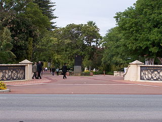
Karrakatta Cemetery is a metropolitan cemetery in the suburb of Karrakatta in Perth, Western Australia. Karrakatta Cemetery first opened for burials in 1899, the first being that of wheelwright Robert Creighton. Managed by the Metropolitan Cemeteries Board, the cemetery attracts more than one million visitors each year. Cypress trees located near the main entrance are a hallmark of Karrakatta Cemetery. The cemetery contains a crematorium, and in 1995 Western Australia's first mausoleum opened at the site.

Perth Hills is a term used primarily for marketing purposes to identify the part of the Darling Scarp and hinterland east of the scarp that lies within the Shire of Mundaring, City of Swan, and the City of Kalamunda and as part of the constituent bodies belonging to the Eastern Metropolitan Regional Council of Perth, Western Australia.

Kalamunda Road is a minor arterial road linking the historic suburb of South Guildford with the Darling Scarp suburb of Kalamunda, in Perth, Western Australia.

Bayswater is a suburb 6 km (4 mi) north-east of the central business district (CBD) of Perth, the capital of Western Australia. It is just north of the Swan River, within the City of Bayswater local government area. It is predominantly a low-density residential suburb consisting of single-family detached homes. However, there are several clusters of commercial buildings, most notably in the suburb's town centre, around the intersection of Whatley Crescent and King William Street and a light industrial area in the suburb's east.
Transport in Perth, Western Australia, is served by various means, among them an extensive highway / freeway network and a substantial system of commuter rail lines and bus routes. Public transport is managed by the Transperth agency.

East Perth Cemeteries was the first cemetery established for the Swan River Colony in 1829 in East Perth, Western Australia. It is estimated that as many as 10,000 people were buried there between 1829 and 1919 in seven independently administered denominations or sections which is why the place is known as 'East Perth Cemeteries'. Only around 800 gravesites have been identified. A large section of the original site has since been built over, leaving about 5 hectares remaining.
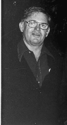
Colin John Jamieson, AO JP, was a politician in Western Australia. A member of the Labor Party, he served as a member of the Western Australian Legislative Assembly from 1953 until 1986, as the Minister for Works and Water Supplies in the Tonkin Ministry (1971–1974) and as Leader of the Opposition (1976–1978). Ron Davies succeeded him in the latter role. He was defeated by incumbent Liberal Premier Sir Charles Court at the state election of 1977.
Midland Cemetery is a metropolitan cemetery in the suburb of Swan view in Perth, Western Australia. In earlier times it was known as the Midland Junction Cemetery due to its control by the local council of that name.
The former Swan District Hospital was a general public hospital in Middle Swan, in Perth's north-eastern suburbs. The hospital had an emergency department, 193 beds, and also provided outpatient services. It closed on 24 November 2015 following the opening of the Midland Health Campus.
Abernethy Road is a 14.7-kilometre (9.1 mi) long minor arterial road linking Belmont with the Great Eastern Highway Bypass in Hazelmere, a suburb of Perth, Western Australia.
Guildford Road is a major road in Perth, Western Australia, linking the inner-city suburb of Mount Lawley with Guildford in the north-east. The ten-kilometre-long (6.2 mi) road runs mostly parallel to the Swan River, on its northern side, and is part of State Route 51, which runs between Perth's CBD and Midvale. Guildford Road is maintained and controlled by Main Roads Western Australia, which uses the internal designation "H026 Guildford Road" for Guildford Road, as well as Bridge Street and James Street in Guildford. In the 1930s, the name Great Eastern Highway was coined to describe the road, but was actually used for the road on the other side of the Swan River.

Mundaring Cemetery is located at the intersection of Yarri Grove and Railway Terrace, Mundaring, Western Australia.

