Gum Tree, Kentucky

Last updated

Gum Tree, Kentucky
Gum-Tree-Voting-House-ky.jpg
Gum Tree Voting House
USA Kentucky location map.svg
Red pog.svg
Gum Tree
Usa edcp location map.svg
Red pog.svg
Gum Tree
Coordinates: 36°43′27″N85°49′10″W / 36.72417°N 85.81944°W / 36.72417; -85.81944
Country United States
State Kentucky
County Monroe
Elevation
938 ft (286 m)
Time zone UTC-6 (Central (CST))
  Summer (DST) UTC-5 (CDT)
ZIP codes
42167
GNIS feature ID508148 [1]

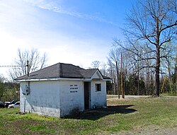
Gum Tree is an unincorporated community located in Monroe County, Kentucky, United States. It is concentrated around the intersection of Kentucky Route 678, Kentucky Route 870, and Kentucky Route 1366, northwest of Tompkinsville, north of Gamaliel, west of Mud Lick, Kentucky, and east of Flippin, Kentucky. Gum Tree is home to one of Monroe County's voting precincts, which had over 900 registered voters as of 2014. [2]

Related Research Articles

<span class="mw-page-title-main">Monroe County, New York</span> County in New York, United States

<span class="mw-page-title-main">Monroe County, West Virginia</span> County in West Virginia, United States

Monroe County is a county in the U.S. state of West Virginia. As of the 2020 census, the population was 12,376. Its county seat is Union.

<span class="mw-page-title-main">Ralls County, Missouri</span> County in Missouri, United States

Ralls County is a county located in the northeastern portion of the U.S. state of Missouri. As of the 2020 census, the population was 10,355. Its county seat is New London. The county was organized November 16, 1820 and named for Daniel Ralls, Missouri state legislator.

<span class="mw-page-title-main">Monroe County, Missouri</span> County in Missouri, United States

Monroe County is a county in northeast Missouri. As of the 2020 census, the population was 8,666. Its county seat is Paris. It is the birthplace of Mark Twain.

<span class="mw-page-title-main">Mississippi County, Missouri</span> County in Missouri, United States

Mississippi County is a county located in the Bootheel of the U.S. state of Missouri, with its eastern border formed by the Mississippi River. As of the 2020 census, the population was 12,577. The largest city and county seat is Charleston. The county was officially organized on February 14, 1845, and was named after the Mississippi River.

<span class="mw-page-title-main">Whitley County, Kentucky</span> County in Kentucky, United States

Whitley County is a county located in the southeastern part of the U.S. state of Kentucky. As of the 2020 census, the population was 36,712. Its county seat is at Williamsburg, though the largest city is Corbin, and the county's District Court sits in both cities. Whitley County is included in the London, KY Micropolitan Statistical Area.

<span class="mw-page-title-main">Monroe County, Kentucky</span> County in Kentucky, United States

Monroe County is a county located in the Eastern Pennyroyal Plateau region of the U.S. state of Kentucky. Its county seat is Tompkinsville. The county is named for President James Monroe. It is a prohibition or dry county.

<span class="mw-page-title-main">Greenup County, Kentucky</span> County in Kentucky, United States

Greenup County is a county located along the Ohio River in the northeastern part of the U.S. state of Kentucky. As of the 2020 census, the population was 35,962. The county was founded in 1803 and named in honor of Christopher Greenup. Its county seat is Greenup. Greenup County is part of the Huntington-Ashland, WV-KY-OH Metropolitan Statistical Area.

<span class="mw-page-title-main">Barren County, Kentucky</span> County in Kentucky, United States

Barren County is a county located in the south-central portion of the U.S. state of Kentucky. As of the 2020 census, the population was 44,485. Its county seat is Glasgow. The county was founded on December 20, 1798, from parts of Warren and Green Counties. It was named for the Barrens, meadowlands that cover the northern third, though actually the soil is fertile. Barren County is part of the Glasgow, KY Micropolitan Statistical Area, which is also included in the Bowling Green-Glasgow, KY Combined Statistical Area. In 2007 Barren County was named the "Best Place to Live in Rural America" by Progressive Farmer Magazine.

<span class="mw-page-title-main">Fountain Run, Kentucky</span> City in Kentucky, United States

Fountain Run is a home rule-class city in Monroe County, Kentucky, in the United States. The population was 216 at the 2020 census.

<span class="mw-page-title-main">Monroe Township, Gloucester County, New Jersey</span> Township in Gloucester County, New Jersey, United States

Monroe Township is a township in Gloucester County, in the U.S. state of New Jersey. As of the 2020 United States census, the township's population was 37,117, its highest decennial count ever and an increase of 988 (+2.7%) from the 36,129 recorded at the 2010 census, which in turn had reflected an increase of 7,162 (+24.7%) from the 28,967 counted at the 2000 census. The township is part of the South Jersey region of the state and a suburb of Philadelphia, within the Delaware Valley.

<span class="mw-page-title-main">Jamesburg, New Jersey</span> Borough in Middlesex County, New Jersey, United States

Jamesburg is a borough in Middlesex County, in the U.S. state of New Jersey. As of the 2020 United States census, the borough's population was 5,783, a decrease of 132 (−2.2%) from the 2010 census count of 5,915, which in turn reflected a decline of 110 (−1.8%) from the 6,025 counted in the 2000 census.

<span class="mw-page-title-main">Monroe Township, Middlesex County, New Jersey</span> Township in Middlesex County, New Jersey, United States

Monroe Township is a township located in southern Middlesex County, in the U.S. state of New Jersey. The township is centrally located within the Raritan Valley region and is an outer-ring suburb of New York City within the New York metropolitan area. As of the 2020 United States census, the township's population was 48,594, its highest decennial count ever and an increase of 9,462 (+24.2%) from the 39,132 recorded at the 2010 census, which in turn had reflected an increase of 11,133 (+39.8%) from the 27,999 from the 27,999 counted at the 2000 census. Monroe Township also comprises the largest land area of any municipality in Middlesex County, at approximately 42 square miles (110 km2).

<span class="mw-page-title-main">Kentucky's 1st congressional district</span> U.S. House district for Kentucky

Kentucky's 1st congressional district is a congressional district in the U.S. state of Kentucky. Located in Western Kentucky, and stretching into Central Kentucky, the district takes in Henderson, Hopkinsville, Madisonville, Paducah, Murray, and Frankfort. The district is represented by Republican James Comer who won a special election to fill the seat of Rep. Ed Whitfield who resigned in September 2016. Comer also won election to the regular term to begin January 3, 2017.

<span class="mw-page-title-main">Mud Lick, Kentucky</span> Unincorporated community in Kentucky, United States

Mud Lick is a rural unincorporated community in Monroe County, Kentucky, United States. It is concentrated around the intersection of Kentucky Route 63 and Kentucky Route 870, northwest of Tompkinsville.

<span class="mw-page-title-main">Flippin, Kentucky</span> Unincorporated community in Kentucky, United States

Flippin is an unincorporated community located in Monroe County, Kentucky, United States. A small residential village and community surround the intersections of Kentucky Route 249, Kentucky Route 678, and Kentucky Route 100, approximately 3.6 miles (5.8 km) south of the Monroe-Barren County line, where the South Fork and main stream of Indian Creek converge.

<span class="mw-page-title-main">1864 United States presidential election in Kentucky</span> Election in Kentucky

The 1864 United States presidential election in Kentucky took place on November 8, 1864, as part of the 1864 United States presidential election. Kentucky voters chose 11 representatives, or electors, to the Electoral College, who voted for president and vice president.

References