
Lake Tana is the largest lake in Ethiopia and a source of the Blue Nile. Located in Amhara Region in the north-western Ethiopian Highlands, the lake is approximately 84 kilometres long and 66 kilometres wide, with a maximum depth of 15 metres, and an elevation of 1,788 metres. Lake Tana is fed by the Gilgel Abay, Reb and Gumara rivers. Its surface area ranges from 3,000 to 3,500 square kilometres, depending on season and rainfall. The lake level has been regulated since the construction of the control weir where the lake discharges into the Blue Nile. This controls the flow to the Blue Nile Falls and hydro-power station.

The Nile is a major north-flowing river in northeastern Africa. It flows into the Mediterranean Sea. The Nile is the longest river in Africa. It has historically been considered the longest river in the world, though this has been contested by research suggesting that the Amazon River is slightly longer. Of the world's major rivers, the Nile is one of the smallest, as measured by annual flow in cubic metres of water. About 6,650 km (4,130 mi) long, its drainage basin covers eleven countries: the Democratic Republic of the Congo, Tanzania, Burundi, Rwanda, Uganda, Kenya, Ethiopia, Eritrea, South Sudan, Sudan, and Egypt. In particular, the Nile is the primary water source of Egypt, Sudan and South Sudan. The Nile is an important economic driver supporting agriculture and fishing.

Ethiopia is located in the Horn of Africa. It is bordered by Eritrea to the north, Djibouti and Somalia to the east, Sudan and South Sudan to the west, and Kenya to the south. Ethiopia has a high central plateau, the Abyssinian Highlands that varies from 1,290 to 3,000 m above sea level, with some 25 mountains whose peaks rise over 4,000 meters (13,200ft), the highest being Ras Dashen at 4,543 meters (14,538ft).

The Blue Nile is a river originating at Lake Tana in Ethiopia. It travels for approximately 1,450 km (900 mi) through Ethiopia and Sudan. Along with the White Nile, it is one of the two major tributaries of the Nile and supplies about 85.6% of the water to the Nile during the rainy season.
The Rift Valley lakes are a series of lakes in the East African Rift valley that runs through eastern Africa from Ethiopia in the north to Malawi in the south, and includes the African Great Lakes in the south. These include some of the world's oldest lakes, deepest lakes, largest lakes by area, and largest lakes by volume. Many are freshwater ecoregions of great biodiversity, while others are alkaline "soda lakes" supporting highly specialised organisms.
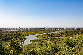
Bahir Dar is the capital city of Amhara Region, Ethiopia. Bahir Dar is one of the leading tourist destinations in Ethiopia, with a variety of attractions in the nearby Lake Tana and Blue Nile river. The city is known for its wide avenues lined with palm trees and a variety of colorful flowers. In 2002, it was awarded the UNESCO Cities for Peace Prize for addressing the challenges of rapid urbanization.

The Amhara Region, officially the Amhara National Regional State, is a regional state in northern Ethiopia and the homeland of the Amhara, Awi, Xamir, Argobba, and Qemant people. Its capital is Bahir Dar which is the seat of the Regional Government of Amhara. Amhara is the site of the largest inland body of water in Ethiopia, Lake Tana, and Semien Mountains National Park. Amhara is bordered by Sudan to the west and northwest and by other the regions of Ethiopia: Tigray to the north, Afar to the east, Benishangul-Gumuz to the west and southwest, and Oromia to the south. Towns and cities in Amhara include: Bahir Dar, Dessie, Gonder, Debre Birhan, Debre Tabor, Kombolcha, Weldiya, Debre Markos, Seqota, Kobo, Metema.Danesha, Humera and wolekait.
Dembiya is a woreda in Amhara Region, Ethiopia. It is named for the former province of Dembiya, which was located roughly in the same location. Part of the Semien, Dembiya is bordered on the south by Lake Tana, on the southwest by Takusa, on the west by Chilga, on the north by Lay Armachiho, and on the east by Gondar Zuria. Towns in Dembiya include Aymiba, Chuahit, Gorgora and Koladiba.
Fogera is a woreda in Amhara Region, Ethiopia. Fogera is part of the Debub Gondar Zone. The district is bordered on the south by Dera, on the west by Lake Tana on the north by the Reb which separates it from Kemekem, on the northeast by Ebenat, and on the east by Farta.

Enfraz or Infraz, also called Guba'e, or Guzara is a historic town and district in northern Ethiopia. Located in the mountainous area overlooking the northeast shore of Lake Tana in the North Gondar Zone of the Amhara Region, it sits at a latitude and longitude of 12°15′30″N37°37′45″E.
The Reb is a river of north-central Ethiopia which empties into Lake Tana in a small delta. The river originates on the slopes of Mount Guna, and flows west through Kemekem woreda. It has no significant tributaries.

Ethiopia's fisheries are entirely freshwater, in its many lakes, rivers, and reservoirs, as it has no marine coastline. Fishing contributed less than 1 percent of the gross domestic product in 1987. A study reported that 15,389 tonnes were caught in 2001, only 30% of an estimated potential of 51,481 tonnes.

The Nile Basin Initiative (NBI) is a partnership among the Nile riparian states that “seeks to develop the river in a cooperative manner, share substantial socioeconomic benefits, and promote regional peace and security”. The NBI began with a dialogue among the riparian states that resulted in a shared vision objective “to achieve sustainable socioeconomic development through the equitable utilization of, and benefit from, the common Nile Basin water resources." It was formally launched in February 1999 by the water ministers of nine countries that share the river: Egypt, Sudan, Ethiopia, Uganda, Kenya, Tanzania, Burundi, Rwanda, the Democratic Republic of Congo (DRC), as well as Eritrea as an observer. From its beginning the Nile Basin Initiative has been supported by the World Bank and by other external partners. The World Bank has a mandate to support the work of the NBI, as lead development partner and as administrator of the multi-donor Nile Basin Trust Fund. One of the partners is the "Nile Basin Discourse", which describes itself as "a civil society network of organisations seeking to achieve positive influence over the development of projects and programmes under the Nile Basin Initiative".
Jikawo River is a river of southwestern Ethiopia. It is a tributary of the Baro River, which it joins at latitude and longitude 8°22′N33°46′E.
The Beles Hydroelectric Power Plant, sometimes referred to as Beles II or Tana Beles, is a run-of-the-river hydroelectric power plant in Ethiopia near Lake Tana. The power plant receives water from the lake through the Tana-Beles interbasin transfer and after utilizing it to produce electricity, the water is then discharged into the Beles River. The plant has an installed capacity of 460 MW, making it the second largest power plant in the country. It is also expected to help provide water for the irrigation of 140,000 ha. It was inaugurated in May 2010 and the last generator became operational in February 2012. Its construction was negatively perceived by downstream Egypt.

Mount Guna is a mountain and shield volcano located near the cities of Nefas Mewcha and Debre Tabor, in the northern Amhara Region of Ethiopia. It is the highest point in the South Gondar Zone, with an elevation of 4,120 metres (13,517 ft) above sea level.
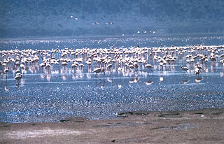
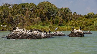
The Lake Tana Biosphere Reserve is a protected area located in the Amhara National Regional State approximately 563 km northwest of Addis Ababa in the north-western part of Ethiopia. The biosphere reserve comprises Lake Tana, the largest lake in Ethiopia, the main source of the Blue Nile, which provides important ecosystem services. The area is a hotspot of biodiversity, internationally known as an Important Bird Area and is of global importance for agricultural genetic diversity. The area is characterized by an enormous heterogeneity of land uses and natural ecosystems.

The Tana-Beles interbasin water transfer takes water from Lake Tana in Ethiopia and delivers it to the Beles River via the Tana Beles hydroelectric power plant. The water downstream is also used for irrigation.

