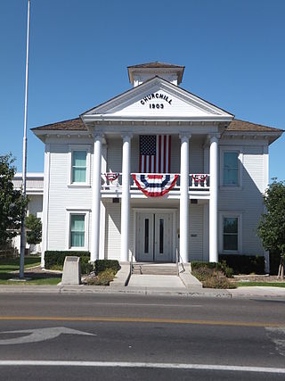
Churchill County is a county in the western U.S. state of Nevada. As of the 2020 census, the population was 25,516. Its county seat is Fallon. Named for Mexican–American War hero brevet Brigadier General Sylvester Churchill, the county was formed in 1861. Churchill County comprises the Fallon, NV Micropolitan Statistical Area. It is in northwestern Nevada. Churchill County is noteworthy in that it owns and operates the local telephone carrier, Churchill County Communications.

Payne County is located in the U.S. state of Oklahoma. As of the 2020 census, its population was 81,646. Its county seat is Stillwater. The county was created in 1890 as part of Oklahoma Territory and is named for Capt. David L. Payne, a leader of the "Boomers".

Webb is the northernmost town in Herkimer County, New York, United States. As of the 2010 census it had a population of 1,807.

Orwell is a town in Oswego County, New York, United States. The population was 1,167 at the 2010 census. The town was named after Orwell, Vermont.

Stillwater is the tenth-largest city in the U.S. state of Oklahoma. It is the county seat of Payne County, Oklahoma. It is located in north-central Oklahoma at the intersection of U.S. Route 177 and State Highway 51. As of the 2020 census, the city population was 48,394. The Stillwater Micropolitan Statistical Area had a population of 78,399 according to the 2012 census estimate. Stillwater was part of the first Oklahoma Land Run held on April 22, 1889, when the Unassigned Lands were opened for settlement and became the core of the new Oklahoma Territory. The city charter was adopted on August 24, 1889, and operates under a council-manager government system.
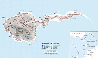
Fort Frank was one of the defense forts at the entrance to Manila Bay established by the United States. The entire island was designated as Fort Frank, in honor of Brigadier General Royal T. Frank, as part of the Harbor Defenses of Manila and Subic Bays built by the Philippine Department of the US Army in the early 1900s.
The Nashua River, 37.5 miles (60.4 km) long, is a tributary of the Merrimack River in Massachusetts and New Hampshire in the United States. It is formed in eastern Worcester County, Massachusetts, at the confluence of the North Nashua River and South Nashua River, and flows generally north-northeast past Groton to join the Merrimack at Nashua, New Hampshire. The Nashua River watershed occupies a major portion of north-central Massachusetts and a much smaller portion of southern New Hampshire.
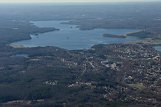
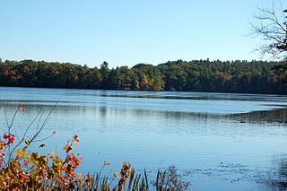
The Wachusett Reservoir is the second largest body of water in the state of Massachusetts. It is located in central Massachusetts, northeast of Worcester. It is part of the water supply system for metropolitan Boston maintained by the Massachusetts Water Resources Authority (MWRA). It has an aggregate capacity of 65 billion US gallons (250,000,000 m3) and an area of almost 7 square miles (18 km2). Water from the reservoir flows to the covered Norumbega Storage Facility via the Cosgrove Tunnel and the MetroWest Water Supply Tunnel. The reservoir has a maximum depth of 120 feet (37 m) and a mean depth of 48 feet (15 m).
The Quinapoxet River is part of the Nashua River watershed in northern Massachusetts in the United States. It is part of the Massachusetts Water Resources Authority water system supplying drinking water to the greater Boston area.

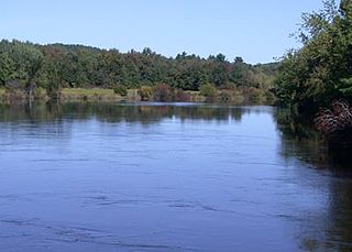
The Stillwater River is part of the Nashua River watershed. This river is part of the Massachusetts Water Resources Authority system that supplies drinking water to the greater Boston area.
The Stillwater River is a river in the U.S. state of Rhode Island. It flows approximately 6.1 miles (9.8 km). There are four dams along the river's length.
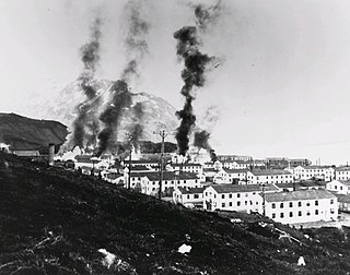
The Battle of Dutch Harbor took place on 3-4 June 1942, when the Imperial Japanese Navy launched two aircraft carrier raids on the Dutch Harbor Naval Operating Base and U.S. Army Fort Mears at Dutch Harbor on Amaknak Island, opening the Aleutian Islands campaign of World War II. The bombing marked the first aerial attack by an enemy on the continental United States and was the second time in history that the continental U.S. was bombed by someone working for a foreign power, the first being the accidental bombing of Naco, Arizona, in 1929.
Beaver River is a hamlet that is six-tenths of a mile square, at the east end of Stillwater Reservoir, in the town of Webb in Herkimer County, New York, United States. The hamlet is surrounded by the Adirondack Park. The hamlet has a year-round population of eight that increases during the summer, as many people have camps in this wilderness area. There are 125 private properties and three commercial businesses. No roads lead to the hamlet; it is accessible only by hiking, small self-propelled private track speeder or boat in the summer and by snowmobile, snowshoes or cross country skis in the winter. There is no electrical service. The town is named for the Beaver River, which was impounded to form the Stillwater Reservoir. The Beaver River is a west-flowing tributary of the Black River and part of the Lake Ontario watershed. The former New York Central Railroad right of way, on the National Register of Historic Places, passes through the hamlet; an existing bunkhouse is a part of the historic property. The Adirondack Railroad will resume tourist passenger service from Utica to Tupper Lake, via Beaver River, in 2023: 42 years since the last passenger train ran on its trackage. The last New York Central Railroad passenger train left Beaver River on April 24, 1965.

The U.S. Army Coast Artillery Corps (CAC) was an administrative corps responsible for coastal, harbor, and anti-aircraft defense of the United States and its possessions between 1901 and 1950. The CAC also operated heavy and railway artillery during World War I.
The Stillwater GeoSolar Hybrid Plant is a combined 61 MW solar energy and geothermal power plant in the U.S. state of Nevada. Located 12 miles (19 km) NE of Fallon, near Stillwater, the site includes a 26MW solar photovoltaic plant and a 2MW solar thermal plant that were added to a 33MW geothermal plant.
Stillwater Reservoir is a man-made lake located by Beaver River, New York within the Western Adirondacks. The lake has a large amount of recreational uses including camping, canoeing, boating, fishing, hunting, snowmobiling, and cross-country skiing. The lake has undeveloped edges with remote camping on both the islands and the shoreline. Camping permits and lake information may be obtained from the hamlet of Stillwater at the Forest Ranger Headquarters. Fish species present in the reservoir are smallmouth bass, splake, rock bass, yellow perch, sunfish and brown trout. There is a state owned hard surface ramp on Stillwater Road, 28 miles east of Lowville, New York. the record low temperature for the state of New York of −52 °F (−47 °C) took place at Stillwater Reservoir, and was later tied by Old Forge on February 17, 1979.
Evergreen Lake is a lake located northeast of Stillwater, New York. The outflow creek flows into Stillwater Reservoir. Fish species present in the lake are brown bullhead, and brook trout. Access via trail from the north shore of Stillwater Reservoir. No motors are allowed on Evergreen Lake.
Gun Harbor Brook is a river in Herkimer County, New York that flows into Stillwater Reservoir at Gun Harbor north of Beaver River, New York.

