Related Research Articles

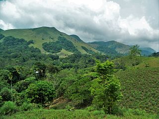
The Western Ghats, also known as the Sahyadris, is a mountain range that stretches 1,600 km (990 mi) along the western coast of the Indian peninsula. Covering an area of 160,000 km2 (62,000 sq mi), it traverses the states of Gujarat, Maharashtra, Goa, Karnataka, Kerala and Tamil Nadu. The range forms an almost continuous chain of mountains along the western edge of the Deccan Plateau from the Tapti river to the southern tip of the Indian peninsula at Kanniyakumari. The Western Ghats meets with the Eastern Ghats at Nilgiris before continuing south.
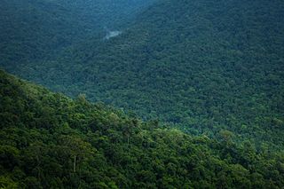
Sholas are the local name for patches of stunted tropical montane forest found in valleys amid rolling grassland in the higher montane regions of South India, largely in Kerala, Karnataka and Tamilnadu. These patches of shola forest are found mainly in the valleys and are usually separated from one another by undulating montane grassland. The shola and grassland together form the shola-grassland complex or mosaic. Not all such high-elevation grasslands have sholas in their valleys, especially if they are isolated from other such meadows, such as the meadows found in the Idamalayar Reserve Forest in Ernakulam district of Kerala. The word 'Shola' is probably derived from the Tamil language word cōlai (சோலை) meaning grove.
The Biligirirangana Hills or Biligirirangan Hills is a hill range situated in Chamarajanagar District in south-western Karnataka, at its border with Tamil Nadu in South India. The area is called Biligiri Ranganatha Swamy Temple Wildlife Sanctuary or simply BRT Wildlife Sanctuary. It is a protected reserve under the Wildlife Protection Act of 1972. Being close to the Eastern Ghats as well as the Western Ghats, the sanctuary has floral and faunal associations with both regions. The site was declared a tiger reserve in January 2011 by the Government of Karnataka, a few months after approval from India's National Tiger Conservation Authority.

Sharavati is a river which originates and flows entirely within the state of Karnataka in India. It is one of the few westward flowing rivers of India and a major part of the river basin lies in the Western Ghats. The famous Jog Falls, located about 25 km from Siddapura, is formed by this river. The river itself and the regions around it are rich in biodiversity and are home to many rare species of flora and fauna.

Kudremukha is the name of a mountain range and an individual mountain peak located in Chikmagalur district, in Karnataka, India. It is also the name of a small hill station and iron ore-mining town situated near the mountain, about 20 kilometres from Kalasa in Kalasa Taluk. The name Kuduremukha literally means "horse-faced" in Kannada and refers to a particular picturesque view of a side of the mountain that resembles a horse's face. It was also referred to as 'Samseparvata', historically since it was approached from Samse village. Kuduremukha is Karnataka's 2nd highest peak after Mullayanagiri and 26th highest peak in western ghats. The nearest International Airport is at Mangalore which is at a distance of 99 kilometres.
The Nilgiri Biosphere Reserve is a biosphere reserve in the Nilgiri Mountains of the Western Ghats in South India. It is the largest protected forest area in India, spreading across Tamil Nadu, Karnataka and Kerala. It includes the protected areas Mudumalai National Park, Mukurthi National Park, Sathyamangalam Wildlife Sanctuary in Tamil Nadu; Nagarhole National Park, Bandipur National Park, both in Karnataka; Silent Valley National Park, Aralam Wildlife Sanctuary, Wayanad Wildlife Sanctuary, and Karimpuzha Wildlife Sanctuary in Kerala.

Periyar, IPA:[peɾijɐːr], is the longest river and the river with the largest discharge potential in the Indian state of Kerala. It is one of the few perennial rivers in the region and provides drinking water for several major towns. The Periyar is of utmost significance to the economy of Kerala. It generates a significant proportion of Kerala's electrical power via the Idukki Dam and flows along a region of industrial and commercial activity. The river also provides water for irrigation and domestic use throughout its course besides supporting a rich fishery. Due to these reasons, the river has been named the "Lifeline of Kerala". Kochi city, in the vicinity of the river mouth, draws its water supply from Aluva, an upstream site sufficiently free of seawater intrusion. Twenty five percent of Kerala's industries are along the banks of the Periyar. These are mostly crowded within a stretch of 5 kilometres (3 mi) in the Eloor-Edayar region (Udhyogamandal), about 10 kilometres (6 mi) north of Kochi harbor.
Athirappilly is a first grade Grama Panchayath with 489.00 km2 area in Chalakudy Taluk, Thrissur district in Kerala, India. It is located 60 km from Thrissur city, 70 km northeast of Kochi city, 55 km northeast of Cochin International Airport, and 30 km from Chalakudy town.

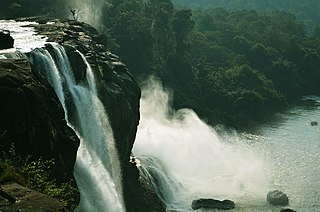
Athirapilly Falls is situated in Athirapilly Panchayat in Chalakudy Taluk of Thrissur District in Kerala, India on the Chalakudy River, which originates from the upper reaches of the Western Ghats at the entrance to the Sholayar ranges. It is the largest waterfall in Kerala, which stands tall at 81.5 feet. Just a short drive from Athirapilly to the Vazhachal Falls, which is close to dense green forests that are home to many endangered and endemic species of flora and fauna.

Bisle is a small village in the heart of south-western India's Western Ghats. The village is located in Hassan District's Sakleshpur (Sakaleshpura) Taluk.

India is one of the most biodiverse regions and is home to a large variety of wildlife. It is one of the 17 megadiverse countries and includes three of the world's 36 biodiversity hotspots – the Western Ghats, the Eastern Himalayas, and the Indo-Burma hotspot.

The state of Karnataka in South India has a rich diversity of flora and fauna. It has a recorded forest area of 38,720 km2 which constitutes 55 of the geographical area of the state. These forests support 25% of the elephant population and 20% of the tiger population of India. Many regions of Karnataka are still unexplored and new species of flora and fauna are still found. The mountains of the Western Ghats in the western region of Karnataka are a biodiversity hotspot. Two sub-clusters of the Western Ghats, Talacauvery and Kudremukh, are on a tentative list of sites that could be designated as World Heritage Sites by UNESCO. The Bandipur and Nagarahole national parks which fall outside these subclusters were included in the Nilgiri biosphere reserve in 1986, a UNESCO designation. In the Biligiriranga Hills the Eastern Ghats meet the Western Ghats. The state bird and state animal of Karnataka are Indian roller and the Indian elephant. The state tree and state flower are sandalwood and lotus. Karnataka is home to 524 tigers.
Gangamoola is a hill in the Chikkamagaluru district of the state of Karnataka, India. Also known as Varaha Parvata, it is one of the hills in the Western Ghats range and is known for being the source of three rivers, Tunga, Bhadra and Netravathi.

The Harangi Dam is located near Hudgur village, Kushalnagar taluk in Kodagu district in the Indian state of Karnataka. The masonry dam is built across the river Harangi, a tributary of the Kaveri. The dam is located about 9 km (5.6 mi) from the heart of Kushalnagar town.

The Melagiris are a range of hills on the Eastern Ghats, bound by the river Cauvery on the west. Melagiri contain an expanse of 1295 km2 of dry deciduous and semi-evergreen forests. It is an elephant country and contains two traditional elephant corridors. With the Bannerghatta National Park in the North east and Cauvery Wildlife Sanctuary in the south, the forest range stretches to sanctuaries of BR Hills and Sathyamangala and joins the tiger reserves of Nilgiri Biosphere. As the meeting point of the Western Ghats and Eastern Ghats, these forests form a vital link in the elephant corridors of South India, connecting the Bannerghatta National Park and the River Cauvery. It borders some of the prominent tiger sanctuaries of the south.

The Mhadei Wildlife Sanctuary is a 208.5-km2 (80.5-mi2) protected area in the Indian state of Goa in the Western Ghats of South India. It is located in the North Goa District, Sattari taluka near the town of Valpoi. The sanctuary is an area of high biodiversity, and is being considered to become a Project Tiger tiger reserve because of the presence of Bengal tigers.
.
Biogeographic classification of India is the division of India according to biogeographic characteristics. Biogeography is the study of the distribution of species (biology), organisms, and ecosystems in geographic space and through geological time. India has a rich heritage of natural diversity. India ranks fourth in Asia and tenth in the world amongst the top 17 mega-diverse countries in the world. India harbours nearly 11% of the world's floral diversity comprising over 17500 documented flowering plants, 6200 endemic species, 7500 medicinal plants and 246 globally threatened species in only 2.4% of world's land area. India is also home to four biodiversity hotspots—Andaman & Nicobar Islands, Eastern Himalaya, Indo-Burma region, and the Western Ghats. Hence the importance of biogeographical study of India's natural heritage.

The Western Ghats Ecology Expert Panel (WGEEP), also known as the Gadgil Commission after its chairman Madhav Gadgil, was an environmental research commission appointed by the Ministry of Environment and Forests of India. The commission submitted the report to the Government of India on 31 August 2011. The Expert Panel approached the project through a set of tasks, such as:
- Compilation of readily available information about Western Ghats
- Development of Geo-spatial database based on environmental sensitivity, and
- Consultation with Government bodies and Civil society groups.
Bisle Reserve Forest is a reserve forest in westernmost Hassan district of Karnataka state, India. It is located in Hassan district's Sakleshpur taluk. Bisle village adjoins the forest to the east. It is contiguous with Kagneri Reserve Forest to the north, Bhagimalai Reserve Forest of Dakshina Kannada district to the west, and Kukke Subramanya forest range to the southwest. To the south it adjoins Pushpagiri Wildlife Sanctuary in Kodagu district. Bisle Reserve forest and the reserve forests extending north along the Bisle Ghat range form a natural corridor linking Pushpagiri Wildlife Sanctuary and Kudremukh National Park.
References
- 1 2 "Expert panel against Gundia project". INTACH. Archived from the original on 26 December 2013. Retrieved 25 December 2013.
- ↑ Dudani, Sumesh (December 2010). "BIODIVERSITY, ECOLOGY AND SOCIO-ECONOMIC ASPECTS OF GUNDIA RIVER BASIN". Lake 2010: Wetlands, Biodiversity and Climate Change. Retrieved 25 December 2013.
- 1 2 "Biodiversity, Ecology and Socio-Economic Aspects of Gundia River Basin in the context of proposed Mega Hydro Electric Power Project" . Retrieved 25 December 2013.
- 1 2 3 "Criticism rising on Karnataka's Gundia project". India Together. 25 December 2009. Retrieved 25 December 2013.
- ↑ "Hydel project across Gundia river finds no favour with expert panel". DNA. 16 September 2010. Retrieved 25 December 2013.
- ↑ "Another Dam Threat To The Western Ghats". Tehelka. 2 November 2011. Archived from the original on 30 October 2013. Retrieved 25 December 2013.