
Karst is a topography formed from the dissolution of soluble carbonate rocks such as limestone and dolomite. It is characterized by features like poljes above and drainage systems with sinkholes and caves underground. There is some evidence that karst may occur in more weathering-resistant rocks such as quartzite given the right conditions.

A sinkhole is a depression or hole in the ground caused by some form of collapse of the surface layer. The term is sometimes used to refer to doline, enclosed depressions that are also known as shakeholes, and to openings where surface water enters into underground passages known as ponor, swallow hole or swallet. A cenote is a type of sinkhole that exposes groundwater underneath. Sink and stream sink are more general terms for sites that drain surface water, possibly by infiltration into sediment or crumbled rock.
Landforms are categorized by characteristic physical attributes such as their creating process, shape, elevation, slope, orientation, rock exposure, and soil type.

A polje, also called karst polje or karst field, is a large flat plain found in karstic geological regions of the world, with areas usually in the range of 5–400 km2 (2–154 sq mi). The name derives from the Slavic languages, where polje literally means 'field', whereas in English polje specifically refers to a karst plain or karst field.

In geology, a depression is a landform sunken or depressed below the surrounding area. Depressions form by various mechanisms.

Acquaviva delle Fonti is a town and comune of 20,446 inhabitants, in the Metropolitan City of Bari, in Apulia, Italy. Acquaviva is famous for its characteristic red onions, which have been awarded the DOP mark. The main monuments are the Palazzo de Mari, the Co-Cathedral of Sant'Eustachio and the ancient village. The town is located on the Murge plateau at an elevation of 300 metres (980 ft) above sea level, and is 26 kilometres (16 mi) from the Adriatic Sea and Bari, which is the biggest city of the region. The Ionian Sea is more than 45 kilometres (28 mi) to the south.
Santeramo in Colle is a town in the Metropolitan City of Bari and region of Apulia, southern Italy.

The Fucine Lake was a large endorheic karst lake between 650 and 680 m above sea level and surrounded by the Monte Sirente-Monte Velino mountain ranges to the north-northeast, Mount Salviano to the west, Vallelonga to the south, and the Valle del Giovenco to the east-southeast. Located in western Abruzzo in central Italy, the town of Avezzano lies to the northwest, Ortucchio to the southeast, and Trasacco to the southwest of the historic lake. Once the third largest lake in Italy after Lake Garda and Lake Maggiore, it was finally drained in 1878.
The Parco Nazionale dell'Alta Murgia is a national park in Apulia, southern Italy, established in 2004. It lies in the Murgia geographical area, with its headquarters in the town of Gravina in Puglia, and has an area of 677.39 square kilometres. It is part of a larger Special Protection Area established to protect the grass steppe, lesser kestrel's habitat.

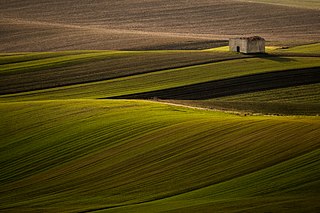
The Altopiano delle Murge is a karst topographic plateau of rectangular shape in southern Italy. Most of it lies within Puglia and corresponds with the sub-region known as Murgia or Le Murge. The plateau lies mainly in the Metropolitan City of Bari and the province of Barletta-Andria-Trani, but extends into the provinces of Brindisi and Taranto to the south, and into Matera in Basilicata to the west. The name is believed to originate from the Latin: murex, meaning 'sharp stone'.
Škocjan Caves Regional Park is located in the Škocjan Karst, a vast flat landscape that lies at an elevation between 420 and 450 m in the southeast part of the Karst area. Following its independence, Slovenia committed itself to protecting the Škocjan Caves area; for this reason, it established Škocjan Caves Regional Park and its managing authority, the Škocjan Caves Park Public Service Agency.

The Metropolitan City of Bari is a metropolitan city in the Apulia region of Italy. Its capital is the city of Bari. It replaced the province of Bari and includes the city of Bari and some forty other comuni. It was first created by the reform of local authorities and then established by the Law 56/2014. It has been operative since January 1, 2015.
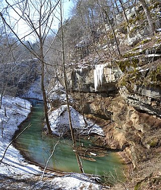
Cedar Sink is a vertical-walled large depression or sinkhole in the ground, located in Edmonson County, Kentucky and contained within and managed by Mammoth Cave National Park. The sinkhole measures 300 feet (91.4 m) from the top sandstone plateau to the bottom of the sink and was caused by collapse of the surface soil. The landscape is karst topography, which means the region is influenced by the dissolution of soluble rocks. Sinkholes, caves, and dolines typically characterize these underground drainage systems. Cedar Sink has a bottom area of about 7 acres (2.8 ha) and has more fertile soil compared to the ridgetops.

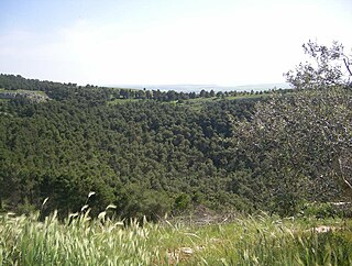
Pulo di Altamura is a doline located on the Murge plateau. It is the largest doline in that region and it is located about 6 kilometers (3.7 mi) north-west of the city of Altamura. It shares the local toponym pulo with other large dolines of the region, i.e. Pulicchio di Gravina, Pulo di Molfetta and Pulicchio di Toritto.
Pulicchio di Gravina is the second-largest doline in the Murge plateau after Pulo di Altamura. It falls into the territory of Gravina in Puglia, located about 10 kilometers (6.2 mi) north of the latter, close to the border with Altamura's territory. It shares the local toponym pulo with other large dolines of the region, i.e. Pulo di Altamura, Pulo di Molfetta and Pulicchio di Toritto.

Lama is a local toponym that denotes a wide furrow in the ground typical of the Murge landscape. Lamas convey rainwater from the Murge plateau to the endpoint of the drainage basin they belong to.

The Karst Living Museum is a nature trail in Slovenia. Part of the Karst Plateau, the museum is an ecologically-important area with many karst features. It was recognized as Slovenia's best thematic trail in 2017, and the region is a Natura 2000 site.
Vito Carmelo Colamonico (Colamonaco) was an Italian geographer, geologist and scholar. His works include studies on some karst dolines and landforms of Italy, such as Pulo di Altamura, Pulicchio di Gravina and Gurio Lamanna.
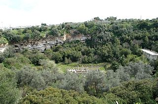
Pulo di Molfetta is a doline located on the Murge plateau, in Apulia, southern Italy, around 1.5 kilometers (0.93 mi) south-west of the city of Molfetta. It originated due to the collapse of the ceiling of one or more caves. It shares the local toponym pulo with other large dolines of the region, i.e. Pulicchio di Gravina, Pulo di Molfetta and Pulicchio di Toritto.


