
Inje County is a county in Gangwon Province, South Korea. It has the lowest population density of any South Korean county. The county seat is Inje-eup, which located near the center of the county.

Yangyang County is in Gangwon Province, South Korea. The county is located in the northeast of the country in Gangwon-do. Its population is about 31,000 (2004).

Sacheon is a city in South Gyeongsang Province, South Korea. Sacheon's chief fame comes from its being the site of two naval battles in the Seven Year War.
Gwandong is a region coinciding with the former Gangwon Province in Korea. Today, the term refers to South Korea's Gangwon Province and North Korea's Kangwon Province. The name is often used to refer to people residing in the region.

The Molucca Sea is located in the western Pacific Ocean, around the vicinity of Indonesia, specifically bordered by the Indonesian Islands of Celebes (Sulawesi) to the west, Halmahera to the east, and the Sula Islands to the south. The Molucca Sea has a total surface area of 77,000 square miles. The Molucca Sea is rich in coral and has many diving sites due to the deepness of its waters. The deepness of the water explains the reasoning behind dividing the sea into three zones, which functions to transport water from the Pacific Ocean to the shallower seas surrounding it. The deepest hollow in the Molucca Sea is the 15,780-foot (4,810-meter) Batjan basin. This region is known for its periodic experiences of earthquakes, which stems from the sea itself being a micro plate, in which the Molucca Sea is being subducted in two opposite directions: one in the direction of the Eurasian Plate to the west and the other in the direction of the Philippine Sea Plate to the east.
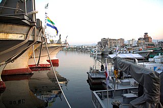
Jumunjin is an eup (town) in northeastern Gangneung City. The population numbers about 20,600, or about 7,000 households. Roughly 10% of these are involved in fisheries and agriculture, respectively. Jumunjin is the site of Jumunjin Harbor, a significant fishing port on the Sea of Japan, home to 394 fishing vessels. Roughly 9.7 of the Jumunjin's 60.55 kilometers are devoted to agriculture.
The Mariner Glacier is a major glacier over 60 nautical miles long, descending southeast from the plateau of Victoria Land, Antarctica, between Mountaineer Range and Malta Plateau, and terminating at Lady Newnes Bay, Ross Sea, where it forms the floating Mariner Glacier Tongue.
Amisan is a mountain in the county of Hongcheon, Gangwon-do in South Korea. It has an elevation of 960.8 m (3,152 ft).
Baegusan (Korean: 백우산) is a mountain in the county of Hongcheon, Gangwon-do in South Korea. It has an elevation of 894.7 m (2,935 ft).
Yaksusan is a mountain in the county of Hongcheon, Gangwon-do in South Korea. It has an elevation of 1,306.2 m (4,285 ft).
Boryeonsan is a mountain in the city of Chungju, North Chungcheong Province in South Korea. It has an elevation of 765 m (2,510 ft).
Gamabong is a mountain of South Korea. It has an elevation of 1,191 metres.
Soppulsan is a mountain of South Korea. It has an elevation of 1,118 metres.
Gakhosan is a mountain of Chungcheongbuk-do, South Korea. It has an elevation of 1,179 metres
Indeungsan is a mountain of South Korea. It has an elevation of 666 metres.
Jakseongsan is a mountain of South Korea. It has an elevation of 846 metres.
Gakhwasan (Korean: 각화산) is a mountain of North Gyeongsang Province, eastern South Korea. It has an elevation of 1,177 metres.
Jangtaesan (Korean: 장태산) is a mountain located in the Jangan-dong neighbourhood of Daejeon, South Korea. It is within the Jangtaesan Natural Recreation Forest, which is known for its dawn redwood (Metasequoia) trees.
Avdotyino is the name of several rural localities in Russia.
