Taif is a city and governorate in the Province of Makkah in Saudi Arabia. Located at an elevation of 1,879 m (6,165 ft) in the slopes of the Hijaz Mountains, which themselves are part of the Sarat Mountains, the city has a population of 563,282 people in 2022, making it one of the most populous cities in the kingdom.

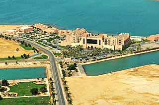
Jeddah, alternatively transliterated as Jedda, Jiddah or Jidda, is a port city in Makkah Province, Saudi Arabia, located along the Red Sea coast in the Hejaz region. Jeddah is the commercial center of the country. It is not known when Jeddah was founded, but Jeddah's prominence grew in 647 when the Caliph Uthman made it a travel hub serving Muslim travelers going to the holy city of Mecca for Islamic pilgrimage. Since those times, Jeddah has served as the gateway for millions of pilgrims who have arrived in Saudi Arabia, traditionally by sea and recently by air.

Majlis is an Arabic term meaning 'sitting room', used to describe various types of special gatherings among common interest groups of administrative, social or religious nature in countries with linguistic or cultural connections to the Muslim world. Majlis can refer to a legislature as well and is used in the name of legislative councils or assemblies in some states.

Asir, officially the Asir Province, is a province in the southwest of Saudi Arabia, which is named after the ʿAsīr tribe. It has an area of 76,693 square kilometres (29,611 sq mi), and an estimated population of 2,024,285. ʿAsīr is surrounded by Mecca Province to the north and west, Al-Bahah Province to the northwest, Riyadh Province to the northeast, Najran Province to the southeast, and Jazan Province and the Yemeni Muhafazah (Governorate) of Saada to the south.

Jazan Province, also spelled Jizan is the second smallest province of Saudi Arabia. It stretches 300 km (190 mi) along the southern Red Sea coast, just north of Yemen. It covers an area of 13,457 km2 and had a population of 1,404,997 at the 2022 census. The region has the highest population density in the Kingdom. The capital is the city of Jazan; Prince Muhammad bin Nasser has been the Governor since April 2001.

The Mecca Province, officially Makkah Province, is one of the 13 provinces of Saudi Arabia. It is the third-largest province by area at 153,128 km2 (59,123 sq mi) and the most populous with a population of 8,557,766 as of 2017, of which 4,041,189 were foreign nationals and 4,516,577 were Saudis. It is located in the historic Hejaz region, and has an extended coastline on the Red Sea. Its capital is Mecca, the holiest city in Islam, and its largest city is Jeddah, which is Saudi Arabia's main port city. The province accounts for 26.29% of the population of Saudi Arabia and is named after the Islamic holy city of Mecca.

Diriyah, formerly romanized as Dereyeh and Dariyya, is a town and governorate in Saudi Arabia. Located on the northwestern outskirts of the Saudi capital, Riyadh. Diriyah was the original home of the Saudi royal family, and served as the capital of the Emirate of Diriyah under the first Saudi dynasty from 1727 to 1818. Today, the town is the seat of the Diriyah Governorate, which also includes the villages of Uyayna, Jubayla, and Al-Ammariyyah, among others—and is part of Ar Riyad Province.
Yanbu, also known as Yambu or Yenbo, is a city in the Al Madinah Province of western Saudi Arabia. It is approximately 300 kilometers northwest of Jeddah. The population is 331,916. Many residents are foreign expatriates working in the oil refineries and petrochemical industry, mostly from Asia, but there are also large numbers from the Middle East, Europe, and North America.

Al-Balad, also known as Jeddah Historic District, is the historical area of Jeddah, the second largest city of Saudi Arabia. Al-Balad can literally be translated to "The Town". Al-Balad is the historic center of the City of Jeddah.
Qatif or Al-Qatif is a governorate and urban area located in Eastern Province, Saudi Arabia. It extends from Ras Tanura and Jubail in the north to Dammam in the south, and from the Persian Gulf in the east to King Fahd International Airport in the west. This region has its own municipality and includes the Qatif downtown, Safwa, Saihat, Tarout Island, and many other smaller cities and towns.

Khalid bin Faisal Al Saud, commonly known as Khalid Al-Faisal, is a Saudi Arabian politician, artist, and poet who is the governor of Makkah Province, in office from 2007 to 2013 and again since 2015. He was the Saudi minister of education from 2013 to 2015. He was also the governor of Asir Province from 1971 to 2007. He served as the adviser to King Salman.
Abha is the capital of 'Asir Region in Saudi Arabia. It is situated 2,270 metres above sea level in the fertile Asir Mountains of south-western Saudi Arabia, near Asir National Park. Abha's mild climate makes it a popular tourist destination for Saudis. Saudis also call the city the Bride of Mountain due to its position above the sea.

Al Baha is a city in south western Saudi Arabia located in the Sarawat Mountains. It is the capital of Al Bahah Region, and is one of the Kingdom's prime tourist attractions. It enjoys a pleasant climate and is surrounded by more than forty forests, including Raghdan, Al-Zaraeb and Baidan. Al Baha is the headquarters of the Governor, local councils and branches of governmental departments. Receiving the state's special attention, the city of Al Baha abounds in educational, tourist and health institutions. It is considered the capital of the Ghamdi and Zahrani tribes in Saudi Arabia, and most of its inhabitants are from the native tribes.
Baljurashi or Biljurashi is a city in Al Bahah Region, south-western Saudi Arabia. It is located at around 19°51′40″N41°33′40″E in the elevation of cca 2,000 metres. It was the capital of the region which includes the tribes of Ghamid and Zahran. It is a medium-sized city in Al Bahah Region. The temperature usually varies between 2 °C (36 °F) in winter and 30 °C (86 °F) in summer. The best time for a visit is from mid-August till the end of September. Most of the native people of Baljurashi live outside it; however, a great number of them spend their summer vacations in the city, which explains the massive increase in population number during summer.

Saudi Arabian cuisine varies according to the diverse landscapes and regions of the country. The environmental, geographic, and cultural diversity within this vast area has led to a wide variety of dishes. Saudi Arabia encompasses different regions, resulting in cuisines from the Central region, Eastern, Southern and Western regions. Furthermore, Saudi Arabia's position along global trade routes has led to the introduction of various spices.

Jabal Soudah is a peak in the Soudah mountains in Saudi Arabia. Jabal Soudah is officially recognized by the Saudi authorities as the highest point in Saudi Arabia, with an elevation of 3,015 metres (9,892 ft).

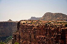
The Asir Mountains is a mountainous region in southwestern Saudi Arabia running parallel to the Red Sea. It comprises areas in the Region of 'Asir, but generally, it also includes areas near the border with Yemen. The mountains cover approximately 100,000 square kilometres (40,000 sq mi) and consists of mountains, plains, and valleys of the Arabian highlands. Sensu lato, they are part of the Sarawat Mountains, defining the latter as the mountain range which runs parallel to the Tihamah throughout the western portion of the Arabian Peninsula, particularly the western parts of Saudi Arabia and Yemen.
Bareq, is one of the governorates of Asir in the north-west of the region, 120 km (75 mi) north of Abha. It occupies a distinct location midway between Tihama and Asir, 412 m (1,352 ft) above sea level. With an estimated population of 75,351, it is well off economically; the city has grown rapidly and has many government services and public utilities available. It is one of Asir's winter resorts because of its natural environment and mild winter weather. Bareq has valleys.
Jebal As-Seqaa is a mountain at 18°13′05″N 42°23′51″E in the Sarwat Mountains of Saudi Arabia, in the region of Asir Belkrb near the city of Abha. At a height of 2863 m (9393 ft) it is the sixth highest mountain in Saudi Arabia.

Soudah is a mountainous area in the Asir region of Saudi Arabia. At 3,015 metres above sea level, it includes Saudi Arabia’s highest peak, Jabal Soudah. The area is known for its dense juniper tree covered mountains.