
Prudhoe is a town in south Northumberland, England, about 11 miles (18 km) west of the city of Newcastle upon Tyne and just south of the River Tyne. The town is sited on a steep, north-facing hill in the Tyne valley and nearby settlements include Ovingham, Ovington, Wylam, Stocksfield, Crawcrook, Hedley on the Hill and Mickley. Prudhoe has a population of over 11,500, measured at 11,675 in the 2011 Census. Today, it has largely become a commuter town for nearby Newcastle.

Newcastle Central Station is a major railway station in Newcastle upon Tyne. It is located on the East Coast Main Line, around 268 miles (432 km) north of London King's Cross.

Haltwhistle is a market town and civil parish in Northumberland, England, 10 miles (16 km) east of Brampton. It had a population of 3,811 at the 2011 Census.

Allendale, often marked on maps as Allendale Town, is a village and civil parish in south west Northumberland, England. It is located within the North Pennines Area of Outstanding Natural Beauty.

Wylam is a village and civil parish in the county of Northumberland. It is located about 10 miles (16 km) west of Newcastle upon Tyne.
Ovingham is a civil parish and village in the Tyne Valley of south Northumberland, England. It lies on the River Tyne 10 miles (16 km) east of Hexham with neighbours Prudhoe, Ovington, Wylam and Stocksfield.

Newburn is a semi rural parish, former electoral ward and former urban district in western Newcastle upon Tyne, North East England. Situated on the North bank of the River Tyne, it is built rising up the valley from the river. It is situated approximately 5 miles (8.0 km) from the city centre, 14 miles (23 km) east of Hexham and 13 miles (21 km) south south west of Morpeth. In the 2001 census, the population was given as 9,301, increasing to 9,536 at the 2011 Census. Newburn is in the Newcastle upon Tyne district of Tyne and Wear and is part of the parliamentary constituency of Newcastle upon Tyne North.

Bank Foot is a Tyne and Wear Metro station, serving the suburb of Kenton Bank Foot, Newcastle upon Tyne in Tyne and Wear, England. It joined the network as a terminus station on 10 May 1981, following the opening of the second phase of the network, between South Gosforth and Bank Foot. The station was used by 0.11 million passengers in 2017–18, making it the third-least-used station on the network, after St Peter's and Pallion.

Wylam is a railway station on the Tyne Valley Line, which runs between Newcastle and Carlisle via Hexham. The station, situated 9 miles 71 chains west of Newcastle, serves the village of Wylam in Northumberland, England. It is owned by Network Rail and managed by Northern Trains.

Stocksfield is a railway station on the Tyne Valley Line, which runs between Newcastle and Carlisle via Hexham. The station, situated 14 miles 47 chains west of Newcastle, serves the villages of Bywell, New Ridley and Stocksfield in Northumberland, England. It is owned by Network Rail and managed by Northern Trains.

Hexham is a railway station on the Tyne Valley Line, which runs between Newcastle and Carlisle via Hexham. The station, situated 22 miles 22 chains west of Newcastle, serves the market town of Hexham in Northumberland, England. It is owned by Network Rail and managed by Northern Trains.

Heddon-on-the-Wall is a village in Northumberland, England, located on Hadrian's Wall. Heddon-on-the-Wall is roughly 9 miles (14 km) west of the centre of Newcastle upon Tyne, and just outside Throckley. The place-name 'Heddon' means 'hill where heather grew'.

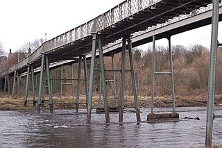
Wylam Railway Bridge is a footbridge and former railway bridge crossing the River Tyne at Hagg Bank, approximately 1⁄2 mile (0.8 km) west of Wylam in Northumberland, England.

Ashington is a town and civil parish in Northumberland, England, with a population of 27,864 at the 2011 Census. It was once a centre of the coal mining industry. The town is 15 miles (24 km) north of Newcastle upon Tyne, west of the A189 and bordered to the south by the River Wansbeck. The North Sea coast at Newbiggin-by-the-Sea is 3 miles (5 km) away.

Clara Vale is a village situated on the south bank of the River Tyne in Tyne and Wear, England. Once an independent village in County Durham it became incorporated into the new metropolitan county of Tyne and Wear in 1974 as part of the Metropolitan Borough of Gateshead.
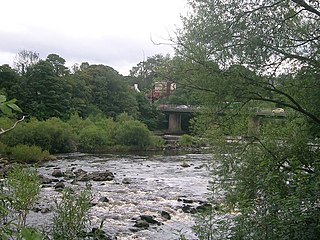
Wylam Bridge is a road bridge in Northumberland, England linking the residential area of North Wylam and neighbouring villages of Heddon-on-the-Wall, and Horsley with the railway station in South Wylam as well as west Gateshead, including the villages of Ryton and Crawcrook.

The Tyne Valley Line is a 58-mile (93 km) route, linking Newcastle upon Tyne with Hexham and Carlisle. The line follows the course of the River Tyne through Tyne and Wear and Northumberland. Five stations and two viaducts on the route are listed structures.
The Scotswood, Newburn and Wylam Railway was a railway company that built the 6+1⁄2 miles (10.5 km) North Wylam branch or North Wylam loop on the former Newcastle & Carlisle Railway. The loop line opened between 1871 and 1876 and followed the former Wylam waggonway past the cottage where George Stephenson was born. The company was taken over by the North Eastern Railway in 1883.

The Newcastle & Carlisle Railway (N&CR) was an English railway company formed in 1825 that built a line from Newcastle upon Tyne on Britain's east coast, to Carlisle, on the west coast. The railway began operating mineral trains in 1834 between Blaydon and Hexham, and passengers were carried for the first time the following year. The rest of the line opened in stages, completing a through route between Carlisle and Gateshead, south of the River Tyne in 1837. The directors repeatedly changed their intentions for the route at the eastern end of the line, but finally a line was opened from Scotswood to a Newcastle terminal in 1839. That line was extended twice, reaching Newcastle Central station in 1851.
