
Ooty, officially known as Udagamandalam, is a town and a municipality in the Nilgiris district of the Indian state of Tamil Nadu. It is located 86 km north of Coimbatore and 128 km south of Mysore and is the headquarters of the Nilgiris district. It is a popular hill station located in the Nilgiri Hills. Local Residents call it Queen of Hills.

The Nilgiris district is in the southern Indian state of Tamil Nadu. Nilgiri is the name given to a range of mountains spread across the borders among the states of Tamil Nadu, Karnataka and Kerala. All types of single use plastics are banned in Nilgiris district. The Nilgiri Hills are part of a larger mountain chain known as the Western Ghats. Their highest point is the mountain of Doddabetta, height 2,637 m. The district is contained mainly within the Nilgiri Mountains range. The administrative headquarters is located at Ooty.

Coonoor is a Taluk and a municipality of the Nilgiris district in the Indian State of Tamil Nadu. As of 2011, the town had a population of 45,494.

Sulthan Bathery, formerly known as Sultan's Battery and Ganapathyvattam is a town and municipality in Wayanad district of Kerala, India, near the borders with Tamil Nadu and Karnataka states. The largest city in Wayanad district, it is the headquarters of Sultan Bathery taluk.

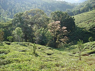
Gudalur is a municipality and taluk in Nilgiris district in the Indian state of Tamil Nadu. Gudalur is one of the major towns in West TamilNadu and is located at 52 km from Ooty in the hilly terrain of The Nilgiris district. It is situated at the junction of Tamil Nadu, Kerala and Karnataka. Gudalur is derived from Moundadan Chetty words "Gudal" and "ooru" (village). Tea plantations dot the whole region, and the regional economy is heavily dependent on the tea industry.This land was an offspring to the exploration done by the British during the pre-independence period to cultivate tea plantation. Being a satellite town between Ooty and Mysore, both tourist spots, Gudalur has the prospect of developing into another tourist destination. Gudalur is a place where one can see people from the three states of Tamil Nadu, Kerala, and Karnataka live together cordially. According to Wikipedia, Gudalur Municipality is 1st largest of Gudalur Taluk and Division, 2nd largest of Nilagiri District and 17th largest of Kongu Nadu region and 117th Largest Municipal Town of Tamil Nadu.

Ketti also called Ketti Valley is a small town nestled in a large valley of the same name. It is located in The Nilgiris District of Tamil Nadu State, South India and is a Revenue Village of Coonoor Taluk. Upper Ketti is another village called Yellanahalli, which is located on the main Coonoor to Ooty road.
Many Ghat Roads can be found in the Nilgiris District of Tamil Nadu, Southern India. Nearly all of the district is located in the Nilgiri Hills, part of the Western Ghats mountains. This area borders the states of Karnataka and Kerala. The hills consequently can be reached by road from three states. Most of these Ghat Roads go through heavily forested mountains and contain a number of sharp hair-pin bends.
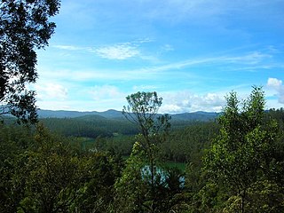
The Nilgiri Mountains form part of the Western Ghats in western Tamil Nadu, India. At least 24 of the Nilgiri Mountains' peaks are above 2,000 metres (6,600 ft), the highest peak being Doddabetta, at 2,637 metres (8,652 ft).
Bandishola is a Panchayat village in Coonoor Taluk of The Nilgiris District, Tamil Nadu, India. The town takes its name from a nearby Shola.
Aravenu is a village in Kotagiri Taluk of The Nilgiris District, Tamil Nadu, India. The population is largely Badaga and it is thought to be an original Badaga Hatti. It is the headquarters of the Jackanarai panchayat.

Burliar is a Panchayat village in Coonoor Taluk of The Nilgiris District, Tamil Nadu, India.
Melur is a Panchayat village in Coonoor Taluk of the Nilgiris District, Tamil Nadu, India.It is located 14 KM towards South from Udhagamandalam and 13 KM from Coonoor, 505 KM from State capital Chennai.
Yedakadu is a serene hamlet located in the Nilgiris Hills in the state of Tamil Nadu in South India. Yedakadu is located 26 km from Udhagamandalam (Ooty) and 38 km from Coonoor. The major occupation of the people is tea plantation. Yedakadu is popular for its 'Sivarathiri', an annual carnival which draws a large crowd from around the Nilgiris. Badaga is the native language. There are three places within the village named "Naduhatty","Sundatty" & "Thalaihatty".
St. Joseph's Higher Secondary School is a boys' school located in the scenic hill station town Ooty, which is part of The Nilgiris district in Tamil Nadu, India. The school was started by Christian missionaries in 1820.

Ooty Bus Stand, also known as Udhagamandalam Central Bus Stand is a bus station located in the town of Ooty. It serves as main bus stand for The Nilgiris district, Tamil Nadu, apart from bus stands in Coonoor, Kotagiri and Gudalur.
Thalayattimund is a locality in the Ooty township of the Nilgiris district in Tamil Nadu, India. It is located by the Ooty-Coonoor road, which is part of the Nilgiri Ghat Roads.
Achanakal is a Badaga village in the Nilgiris district in the Indian state of Tamil Nadu. The village is located adjacent to the Coonoor-Ooty highway in the Ketti valley. The name is believed to be derived from asinikol meaning bamboo sticks in Badaga language which formed the place before the village came into existence. Ketti valley is also considered the second steepest valley in the world. Achanakal is the largest village among the other 13 villages which are located in the valley. The village is just 3 Kilometres away from Ketti and the Lovedale railway stations.
The Coimbatore - Shoranur line connects Coimbatore in the Indian state of Tamil Nadu and Shoranur in Kerala. There is a branch line Pothanur–Coimbatore–Mettupalayam and Mettupalayam to Udhagamandalam via Nilgiri Mountain Railway. This network links the railway network in Kerala to the network in Tamil Nadu via the Palakkad Gap.
Mulligoor (முள்ளிகூர்) is a village in the Kundah taluk of Nilgiris District of Tamil Nadu State, India. It is situated 10 kilometers away from sub-district headquarters Kundah and 30 kilometers from district headquarters Ooty. The main cultivation in Mulligoor is tea growing. This area surrounding Mulligoor is also very rich in wildlife.

Mysore-Ooty Road or Mysore-Udhagamandalam Road is a tourist trail of South India starting from Mysore in Karnataka state and ending in Udhagamandalam in Nilgiri district of Tamil Nadu state, India. Both routes pass through Bandipur National park in Karnataka and Mudumalai National Park in Tamil Nadu.