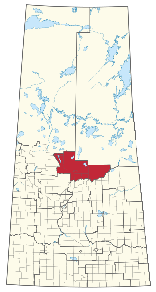
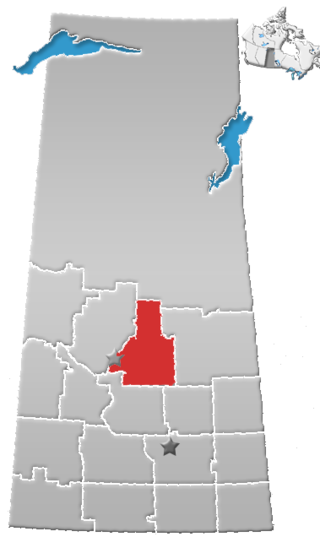
Saskatchewan Rivers is a provincial electoral district for the Legislative Assembly of Saskatchewan, Canada. This constituency is located where the North Saskatchewan River and the South Saskatchewan River merge.

The Muskoday First Nation is a First Nation band government in Saskatchewan, Canada, composed of Cree and Saulteaux peoples. The First Nation has a registered population of 1,828 people as of September 2014, of which approximately 623 members of the First Nation live on-reserve, and approximately 1204 live off-reserve. Muskoday's territory is located in the aspen parkland biome. It is bordered by the rural municipalities of Birch Hills No. 460 and Prince Albert No. 461.
Albertville is a village in the Canadian province of Saskatchewan within the Rural Municipality of Garden River No. 490 and is in Census Division No. 15. It is approximately 25 km northeast of the City of Prince Albert.
Red Deer Hill is a community in Saskatchewan, Canada south of Prince Albert and north of St. Louis. First settlement occurred in the 1870s and 1880s by Anglo-Metis from Manitoba, and the area took its name from a large hill which in the early days was populated by many elk or "red deer". The area is part of the aspen parkland biome.
MacDowall, Saskatchewan is an organized hamlet in Duck Lake No. 463 Saskatchewan, Canada. The hamlet is located approximately 30 km southwest of Prince Albert, Saskatchewan and is situated on the northern edge of the Nisbet Provincial Forest, adjacent to the Louis Riel Trail also known as Highway 11. It is a short distance northwest of the village of St. Louis, and just west of Red Deer Hill. MacDowall is located in the aspen parkland biome.
Division No. 15 is one of eighteen census divisions in the province of Saskatchewan, Canada, as defined by Statistics Canada. It is located in the north-central part of the province. The most populous community in this division is Prince Albert.

Pleasant Hill is a neighbourhood of Saskatoon, Saskatchewan, Canada. The Governments are undertaking a major re-vitalization project of Pleasant Hill. $3.5 million is being invested in the business, and residential areas as well as in St. Mary's School. Together the Saskatoon Urban Renewal Project, the provincial government and the Western Economic Diversification project of the federal Government will result in neighbourhood overhauls. 29 lots zoned for business along 20th Street will be levelled and modern commercial upgrades put into place. Selected lots along Avenue N and Avenue O zoned as residential will be demolished to make way for affordable and decent homes. St. Mary's School will receive major renovations or replacement, possibly even a new community centre.

Carrot River is a river in Western Canada in the north-eastern part Saskatchewan and the north-western part of Manitoba. The outlet of Wakaw Lake in Saskatchewan marks the beginning of the Carrot River and, from there, it flows north-east past several communities and Indian reserves until it joins the Saskatchewan River in the Cumberland Delta in Manitoba. The river's mouth is west and upstream of the Pasquia River and The Pas on the Saskatchewan River.

Turtleford is a town in the Rural Municipality of Mervin No. 499, in the Canadian province of Saskatchewan. Turtleford is located on Highway 26 near the intersection / concurrency with Highway 3 and Highway 303. The nearest cities are North Battleford and Lloydminster. The Turtlelake River runs through Turtleford, and nearby are Brightsand Lake and Turtle Lake.

Drypool is an area within the city of Kingston upon Hull, in the ceremonial county of the East Riding of Yorkshire, England.
Fenton, formerly Adams Crossing, is an unincorporated community south-east of Prince Albert, Saskatchewan, Canada. It is 13 kilometres (8.1 mi) west from Birch Hills. Fenton is on the banks of the South Saskatchewan River, east of Halcro and south-west of the Muskoday First Nation. The Fenton Ferry is operational seasonally and hosts mainly local traffic. Fenton has a long history dating back to Anglo-Metis settlement before the North-West Rebellion. It is situated in the Aspen parkland biome.
Davis is an unincorporated community south of Prince Albert, Saskatchewan, Canada. Davis was once a village but has since shrunk to a handful of houses. It is just northwest of the Muskoday First Nation and southeast of Prince Albert. Davis was named for Senator Thomas Osborne Davis a prominent Prince Albert merchant and Liberal Party member in the late nineteenth and early twentieth century. Davis is located in the Aspen parkland biome.

CKBI is a commercial AM radio station in Prince Albert, Saskatchewan. Owned by the Jim Pattison Group, it broadcasts a country radio format branded as 900 CKBI. The studios and offices are on Central Avenue in Prince Albert. CKBI is the broadcast home of the Prince Albert Raiders of the Western Hockey League, and also carries live broadcasts of Saskatchewan Roughriders CFL games.
Donavon is a hamlet in Montrose Rural Municipality 315, Saskatchewan, Canada. The hamlet is located southwest of Saskatoon along Highway 45 and Canadian National Railway, Delisle-Tichfield Junction stub.

Sturgeon River is a river in the Hudson Bay drainage basin in the central part of the Canadian province of Saskatchewan. It flows from its source in the Waskesiu Hills in Prince Albert National Park to the North Saskatchewan River, just west of the city of Prince Albert.

Horizon, located on the south side of Channel Lake, is a hamlet in Bengough Rural Municipality No. 40, Saskatchewan, Canada. It previously held the status of village until December 31, 1973. The hamlet is located 60 km (37 mi) east of the Town of Assiniboia on highway 13.

Lac La Ronge Provincial Park is located in the boreal forest of the north central part of the Canadian province of Saskatchewan within the Canadian Shield. Situated in the Churchill River system, this provincial park has close to 100 lakes and more than 30 canoe routes, many of which follow old fur trade routes. Summer activities include camping, hiking, boating, fishing, and swimming. In the winter, there's cross-country skiing, snowmobiling, and ice fishing. Saskatchewan's highest waterfall is in the park. Nistowiak Falls are located north of Lac La Ronge along the Rapid River.
Prince Albert Indian Residential School was a Canadian residential school operated by the Anglican Church for First Nations children in Prince Albert, Saskatchewan. It was located on the West Hill of Prince Albert in a former army barracks.
Pasquia Hills are hills in the Canadian province of Saskatchewan. They are located in the east central part of the province in the RM of Hudson Bay No. 394 near the Manitoba border. The hills are the northern most in a series of hills called the Manitoba Escarpment. The Manitoba Escarpment marks the western edge of the pre-historical glacial Lake Agassiz. The other four hills include Porcupine Hills, Duck Mountain, and Riding Mountain.
