
Hallock is a city in and the county seat of Kittson County, Minnesota, United States. The population was 906 at the 2020 census.
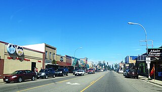
Walker is a city in Cass County, Minnesota, United States. The population was 966 at the 2020 census. It is the county seat of Cass County.

Charlevoix Municipal Airport is a city-owned, public-use airport located one nautical mile (2 km) southwest of the central business district of Charlevoix, a city in Charlevoix County, Michigan, United States. It is mostly used for general aviation, but also offers passenger service to Beaver Island via Island Airways and Fresh Air Aviation.
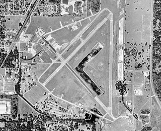
Zephyrhills Municipal Airport is a public use airport in Pasco County, Florida, United States. It is owned by the City of Zephyrhills and located one nautical mile (2 km) southeast of its central business district. This airport is included in the National Plan of Integrated Airport Systems for 2011–2015, which categorized it as a general aviation facility.

Zamperini Field is a public airport three miles (5 km) southwest of downtown Torrance, in Los Angeles County, California, United States.
New Ulm Municipal Airport is a public airport located two statute miles (3 km) west of the central business district (CBD) of New Ulm, a city in Brown County, Minnesota, United States. This general aviation airport covers 195 acres (79 ha) and has two runways. Operational since September 1945, scheduled airline service was once available on Midwest Aviation, also known as Lake State Airways, though today only charter flights are offered by the city's New Ulm Flight Service, founded in the 1960s.

Benton Municipal Airport is a city-owned, public-use airport located 1 nautical mile west of the central business district of Benton, a city in Franklin County, Illinois, United States. This airport is included in the FAA's National Plan of Integrated Airport Systems (2009-2013), which categorizes it as a general aviation airport. The airport was named 2014 Illinois General Aviation Airport of the Year.
Middleton Municipal Airport, also known as Morey Field, is a general aviation airport located five miles (8 km) northwest of Middleton, a city in Dane County, Wisconsin, United States. It is included in the Federal Aviation Administration (FAA) National Plan of Integrated Airport Systems for 2021–2025, in which it is categorized as a regional general aviation facility.
Mount Pleasant Municipal Airport is a city-owned public-use airport located two miles (3 km) northeast of the central business district of Mount Pleasant, a city in Isabella County, Michigan, United States. The airport became active in 1940. It serves general aviation for Mount Pleasant and the surrounding area. It is included in the Federal Aviation Administration (FAA) National Plan of Integrated Airport Systems for 2017–2021, in which it is categorized as a local general aviation facility.
Jack Barstow Airport, also known as Jack Barstow Municipal Airport, is a city-owned, public-use airport located three nautical miles (6 km) northwest of the central business district of Midland, a city in Midland County, Michigan, United States. It is included in the Federal Aviation Administration (FAA) National Plan of Integrated Airport Systems for 2017–2021, in which it is categorized as a local general aviation facility.
Blue Earth is a city-owned public-use airport located three miles south of the city of Blue Earth, Minnesota in Faribault County.
Cook Municipal Airport is a city-owned public-use airport located two miles south of the city of Cook, Minnesota in Saint Louis County.
Worthington Municipal Airport is a city-owned public-use airport located 2 miles (3.2 km) north of the city of Worthington, in Nobles County, Minnesota, United States.
Paynesville Municipal Airport is a city-owned public-use airport located one mile southwest of the city of Paynesville, Minnesota in Stearns County.
Eveleth–Virginia Municipal Airport is a city-owned public-use airport located three miles southeast of the city of Eveleth, Minnesota
Glencoe Municipal Airport also known as Vernon Perschau Field is a city-owned public-use airport located three miles south-east of the city of Glencoe, Minnesota in McLeod County.
Hawley Municipal Airport is a city-owned public-use airport located four miles south-east of the city of Hawley, Minnesota in Clay County.
Rushford Municipal Airport also known as Robert W. Bunke Field is a city-owned public-use airport located three miles west of the city of Rushford, Minnesota in Fillmore County.
Windom Municipal Airport is a city-owned public-use airport located three miles north of the city of Windom, Minnesota in Cottonwood County.
Redwood Falls Municipal Airport is a city-owned public-use airport located two miles north-east of the city of Redwood Falls, Minnesota in Redwood County.

