Circuito de Jerez-Ángel Nieto, is a 4.428 km (2.751 mi) racing circuit located close to the city of Jerez de la Frontera, 90 km (55.9 mi) south of Seville and deep within the sherry-producing south of Spain. The project was led by the Spanish engineer Manuel Medina Lara, based on a preliminary idea from Alessandro Rocci.

Kojetice is a village in the Mělník District, Central Bohemian Region of the Czech Republic. On the date October 2, 2006 it has 652 inhabitants. First written notice about village is from year 1271. It is a member of Mikroregion Povodí Mratínského potoka.

Nerkin Tsaghkavan ; formerly known as Melikgyugh or Melikgegh, is a village in the Tavush Province of Armenia.

Łyków is a village in the administrative district of Gmina Świnice Warckie, within Łęczyca County, Łódź Voivodeship, in central Poland. It lies approximately 8 kilometres (5 mi) east of Świnice Warckie, 13 km (8 mi) west of Łęczyca, and 42 km (26 mi) north-west of the regional capital Łódź.

Cəfərli is a village in the Qazakh Rayon of Azerbaijan.
Kamionka is a village in the administrative district of Gmina Kobiele Wielkie, within Radomsko County, Łódź Voivodeship, in central Poland.

Tarm is a small railway town with a population of 4,084 in west Denmark, 36 kilometres southwest of Herning. The road distance between Herning and Tarm is exactly 47,8 kilometres.

Saint-Ouen-l'Aumône-Liesse is a railway station in Saint-Ouen-l'Aumône, a northwestern suburb of Paris, France. It is served by Transilien regional trains from Paris to Pontoise, and by RER rapid transit.
Imiełków is a village in the administrative district of Gmina Tuliszków, within Turek County, Greater Poland Voivodeship, in west-central Poland. It lies approximately 9 kilometres (6 mi) south-east of Tuliszków, 8 km (5 mi) west of Turek, and 109 km (68 mi) east of the regional capital Poznań.
Borzykowo is a settlement in Gmina Miastko, Bytów County, Pomeranian Voivodeship, in northern Poland.
Mostniki is a settlement in the administrative district of Gmina Dobiegniew, within Strzelce-Drezdenko County, Lubusz Voivodeship, in western Poland. It lies approximately 16 kilometres (10 mi) north-east of Dobiegniew, 34 km (21 mi) north-east of Strzelce Krajeńskie, and 58 km (36 mi) north-east of Gorzów Wielkopolski.
Witków is a village in the administrative district of Gmina Szprotawa, within Żagań County, Lubusz Voivodeship, in western Poland. It lies approximately 8 kilometres (5 mi) north of Szprotawa, 15 km (9 mi) east of Żagań, and 35 km (22 mi) south of Zielona Góra.
Banasiówka is a village in the administrative district of Gmina Rudniki, within Olesno County, Opole Voivodeship, in south-western Poland.
Martiany is a village in the administrative district of Gmina Kętrzyn, within Kętrzyn County, Warmian-Masurian Voivodeship, in northern Poland. It lies approximately 11 kilometres (7 mi) south-east of Kętrzyn and 73 km (45 mi) east of the regional capital Olsztyn.

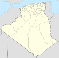
Bordj T'har is a town and commune in Jijel Province, Algeria. According to the 1998 census it has a population of 4893.
Ouled Gacem is a town and commune in Oum El Bouaghi Province, Algeria. According to the 1998 census it has a population of 6273.
Metsaküla is a village in Häädemeeste Parish, Pärnu County in southwestern Estonia.
Tõre is a village in Saaremaa Parish, Saare County in western Estonia.

Konosu Stadium (鴻巣市立陸上競技場) is an athletic stadium in Konosu, Saitama, Japan.
Stoddard is an unincorporated community in Stoddard County, in the U.S. state of Missouri.