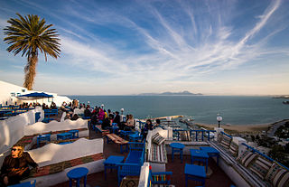
Sidi Bou Said is a town in northern Tunisia located about 20 km from the capital, Tunis.

Bou Saada is a town and municipality in M'Sila Province, Algeria, situated 245 km south of Algiers. As Arena it was the site of a city and bishopric in Roman Africa, now a Catholic titular see. The municipal population was estimated at 134,000 in 2008.

Little Andrews Bay Marine Provincial Park is a provincial park in British Columbia, Canada, located on Ootsa Lake in the Nechako Country in that province's Central Interior. It is 102 ha. in size.
The École Nationale Supérieure de Chimie et de Physique de Bordeaux or ENSCPB - which can be translated as Graduate School of Chemistry and Physics of Bordeaux - is one of the French "grandes écoles", whose main purpose is to form chemical and physical engineers. It is located on the campus of the University of Bordeaux 1, in the town of Pessac, close to the famous city of Bordeaux.

Sergelen is a sum of Töv Province in Mongolia.
Faulder is a railway point located in British Columbia, Canada, situated in a large valley ten kilometers west of the town of Summerland. This is also the end point of the Kettle Valley Steam Railway. Named after Evelyn Robert Faulder, it consists of many large acreages and agricultural farms.

Głowaczewo is a village in the administrative district of Gmina Wałcz, within Wałcz County, West Pomeranian Voivodeship, in north-western Poland. It lies approximately 12 kilometres (7 mi) north-east of Wałcz and 136 km (85 mi) east of the regional capital Szczecin.

Gębice is a village in the administrative district of Gmina Mogilno, within Mogilno County, Kuyavian-Pomeranian Voivodeship, in north-central Poland. It lies approximately 9 kilometres (6 mi) south-east of Mogilno, 58 km (36 mi) south of Bydgoszcz, and 62 km (39 mi) south-west of Toruń.
Boża Wola is a village in the administrative district of Gmina Adamów, within Zamość County, Lublin Voivodeship, in eastern Poland. It lies approximately 11 kilometres (7 mi) east of Adamów, 13 km (8 mi) south of Zamość, and 88 km (55 mi) south-east of the regional capital Lublin.
Diament is a village in the administrative district of Gmina Jędrzejów, within Jędrzejów County, Świętokrzyskie Voivodeship, in south-central Poland. It lies approximately 4 kilometres (2 mi) south-west of Jędrzejów and 40 km (25 mi) south-west of the regional capital Kielce.
Pułanki is a village in the administrative district of Gmina Frysztak, within Strzyżów County, Subcarpathian Voivodeship, in south-eastern Poland. It lies approximately 2 kilometres (1 mi) north of Frysztak, 13 km (8 mi) west of Strzyżów, and 35 km (22 mi) south-west of the regional capital Rzeszów.
Wola Starogrodzka is a village in the administrative district of Gmina Parysów, within Garwolin County, Masovian Voivodeship, in east-central Poland. It lies approximately 7 kilometres (4 mi) north-west of Parysów, 12 km (7 mi) north of Garwolin, and 48 km (30 mi) south-east of Warsaw.

Cliff is a census-designated place in Grant County, New Mexico, United States. Its population was 293 as of the 2010 census.
Tomice is a village in the administrative district of Gmina Stęszew, within Poznań County, Greater Poland Voivodeship, in west-central Poland. It lies approximately 9 kilometres (6 mi) north-west of Stęszew and 23 km (14 mi) west of the regional capital Poznań.
Pranie is a settlement in the administrative district of Gmina Ruciane-Nida, within Pisz County, Warmian-Masurian Voivodeship, in northern Poland. It lies approximately 5 kilometres (3 mi) south-west of Ruciane-Nida, 20 km (12 mi) west of Pisz, and 69 km (43 mi) east of the regional capital Olsztyn.
Białuń is a village in the administrative district of Gmina Goleniów, within Goleniów County, West Pomeranian Voivodeship, in north-western Poland. It lies approximately 8 kilometres (5 mi) north of Goleniów and 28 km (17 mi) north-east of the regional capital Szczecin.
Ostrzyca is a village in the administrative district of Gmina Nowogard, within Goleniów County, West Pomeranian Voivodeship, in north-western Poland. It lies approximately 8 kilometres (5 mi) south-east of Nowogard, 26 km (16 mi) east of Goleniów, and 46 km (29 mi) north-east of the regional capital Szczecin.
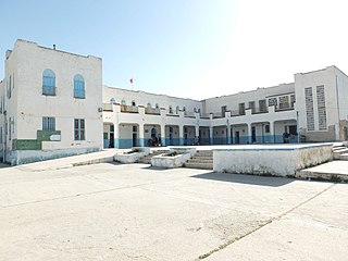
Bou Salem (بوسالم) is a town and commune in the Jendouba Governorate, Tunisia. As of 2004 it had a population of 20,098. by 2014 this had grown 35,192.
Sri Biranchinarayan Temple is in Palia village, which is located 15 kilometres (9.3 mi) south of Bhadrak District, Odisha, India on the way from Bhadrak to Chandabali. It occupies a significant place in the cultural map of Odisha state of India. Today, the standing Biranchi Narayan Temple stands as evidence of the heritage of Surya Upasana in Odisha. Biranchi Narayan is another name for Lord Surya, the Sun God of light and lustre. The existing temple is dedicated to Biranchi-narayan, who is enshrined as a roughly four-faced image of the Sun. A square stone slightly tapering towards the top contains four carved images of the Sun god in relief, on the four sides of a slab. The figures hold two lotuses in two hands, as usual, and are depicted standing on chariots drawn by seven horses. Architecturally, the temple can be dated to the 13th century. It was renovated and reconstructed in the beginning of the 20th century by the generosity of a local zamindar.

Bou-Nouh is a town and commune in Tizi Ouzou Province in northern Algeria.


