Howard County is located in the U.S. state of Maryland. As of the 2010 census, the population was 287,085. As of the 2020 census its population rose to 328,200. Its county seat is Ellicott City.
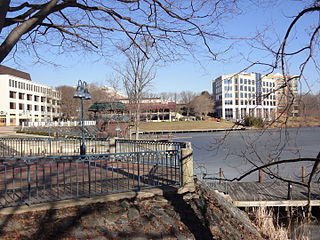
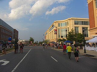
Columbia is a census-designated place in Howard County, Maryland, United States, and is one of the principal communities of the Baltimore–Washington metropolitan area. It is a planned community consisting of 10 self-contained villages.

North Laurel is a census-designated place (CDP) in Howard County, Maryland, United States. The published population was 4,474 at the 2010 census. This population was substantially less than the CDP's population in 2000, and was the result of an error in defining the boundary prior to tabulation and publication of 2010 Census results. The corrected 2010 Census population is 20,259. North Laurel is adjacent to the City of Laurel, which is located across the Patuxent River in Prince George's County.

Laurel is a city in Maryland, United States, located midway between Washington and Baltimore on the banks of the Patuxent River. While the city limits are entirely in northern Prince George's County, outlying developments extend into Anne Arundel, Montgomery and Howard counties. Founded as a mill town in the early 19th century, Laurel expanded local industry and was later able to become an early commuter town for Washington and Baltimore workers following the arrival of the Baltimore and Ohio Railroad in 1835. Largely residential today, the city maintains a historic district centered on its Main Street, highlighting its industrial past.

Clarksville is an unincorporated community in Howard County, Maryland; the second highest-earning county in the United States according to the U.S. Census Bureau. The community is named for William Clark, a farmer who owned much of the land on which the community now lies and served as a postal stop that opened on the 4th of July 1851.

Guilford is an unincorporated community located in Howard County in the state of Maryland. The location is named after the Guilford Mill. Guilford is near Kings Contrivance, one of the nine "villages" of Columbia.

Savage is an unincorporated community and census-designated place located in Howard County, Maryland, United States, approximately 18 miles (29 km) south of Baltimore and 21 miles (34 km) north of Washington, D.C. It is situated close to the city of Laurel and to the planned community of Columbia. As of the 2010 census it had a population of 7,054. The former mill town is a registered historic place, and has many original buildings preserved within and around the Savage Mill Historic District.

River Hill is the last and westernmost village to be developed in the town of Columbia, Maryland, United States, though some residents maintain addresses in Clarksville. The village is home to 6,520 residents in 2,096 housing units in 2014. The area was used as a game preserve by James Rouse to entertain clients and personal hunting during the buildout of the Columbia project. In 1976, County Executive Edward L. Cochran selected the 784-acre parcel owned by Howard Research and Development for an alternate location for a county landfill; a task force selected Alpha Ridge Landfill instead. Residential construction started in 1990. It is bounded by Maryland Route 108 and Maryland Route 32, and is centered on Trotter Road. The village is divided into two neighborhoods: Pheasant Ridge and Pointers Run, with about 6,500 residents.
Kings Contrivance is a village in the planned community of Columbia, Maryland, United States and is home to approximately 11,000 residents. It is Columbia's southernmost village, and was the eighth of Columbia's ten villages to be developed. Kings Contrivance consists of the neighborhoods of Macgill's Common, Huntington and Dickinson, and includes single-family homes, townhouses, apartments and a Village Center.

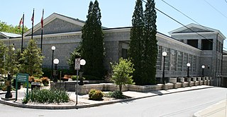
Howard County General Hospital is a 267-bed, not-for-profit health care provider located in Columbia, Maryland.
Oakland Mills is one of the 10 villages in Columbia, Maryland, United States. It is located immediately east of Town Center, across U.S. Route 29.

Hanover is an unincorporated community in the Baltimore/Annapolis area in northwestern Anne Arundel County and eastern Howard County in the U.S. state of Maryland, located south of Baltimore.
The Howard County Public School System (HCPSS) is the school district that manages and runs the public schools of Howard County, Maryland. It operates under the supervision of an elected, eight-member Board of Education. Dr. Chao Wu is the Chairman of the Board. Michael J. Martirano has served as the Superintendent since May 2017.
Baltimore County Public Schools is the school district in charge of all public schools in Baltimore County, Maryland, United States. It is the 25th largest school system in the US as of 2013. The school system is managed by the Board of Education, headquartered in Towson. The superintendent is Darryl L. Williams, appointed by the School Board on June 11, 2019.
Fulton is an unincorporated community and census-designated place located in southern Howard County, Maryland, United States. As of the 2010 census it had a population of 2,049.

Whiskey Bottom Road is a historic road north of Laurel, Maryland that traverses Anne Arundel and Howard Counties in an area that was first settled by English colonists in the mid-1600s. The road was named in the 1880s in association with one of its residents delivering whiskey after a prohibition vote. With increased residential development after World War II, it was designated a collector road in the 1960s; a community center and park are among the most recent roadside developments.

The Middle Patuxent Environmental Area (MPEA) is a 1,021-acre (4.13 km2) wildlife area in Clarksville, Maryland and operated by the Howard County Department of Recreation and Parks. It is located next to the River Hill village in the town of Columbia, Maryland, in the United States. The MPEA was created in 1996 for educational, research, and recreational purposes.
Norman E. Moxley was an American politician and businessman in Howard County, Maryland
Melvin James Berman, was a prominent land developer in Maryland. He was instrumental in the creation of Columbia, Maryland along with his development partner James Rouse.

The Howard County Department of Planning and Zoning (DPZ) manages planning and development in Howard County, Maryland, a Central Maryland jurisdiction equidistant between Baltimore, Maryland and Washington, D.C.
