Manyara Region is one of Tanzania's 31 administrative regions. The regional capital is the town of Babati. According to the 2012 national census, the region had a population of 1,425,131, which was lower than the pre-census projection of 1,497,555. For 2002–2012, the region's 3.2 percent average annual population growth rate was tied for the third highest in the country. It was also the 22nd most densely populated region with 32 people per square kilometre.

Babati Rural District is a district of Manyara Region of Tanzania, East Africa. The administrative capital of the district is Babati town, 172 km (107 mi) south of Arusha. The district covers an area of 6,069 km2 (2,343 sq mi), a large proportion (640 km2) of which is covered by the water bodies of Lake Babati, Lake Burunge and Lake Manyara. The district is bordered to the north by Arusha Region, to the south east by Simanjiro District, to the south by Dodoma Region, to the south west by Hanang District, and to the north west by Mbulu District. Babati Urban District is located within the district.

Arusha Region is one of Tanzania's 31 administrative regions and is located in the north of the country. The region's capital and largest city is the city of Arusha. The region is bordered by Kajiado County and Narok County in Kenya to the north, the Kilimanjaro Region to the east, the Manyara and Singida Regions to the south, and the Mara and Simiyu regions to the west. Arusha Region is home to Ngorongoro Conservation Area, a UNESCO World Heritage Site. The region is comparable in size to the combined land and water areas of the state of Maryland in the United States.

Meatu District is one of the five districts of the Simiyu Region of Tanzania. It is bordered to the north by the Itilima District, to the west by the Maswa District and Shinyanga Region to the east by the Arusha Region, to the southeast by the Manyara Region and to the south by the Singida Region. Its district capital is the town of Mwanhuzi.
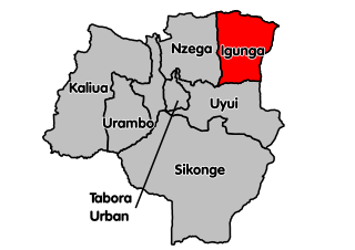
Igunga is one of the seven districts of the Tabora Region of Tanzania. It is bordered to the north by the Shinyanga Region, to the east by the Singida Region, to the south by the Uyui District and to the west by the Nzega District. Its administrative seat is the town of Igunga. Igunga is now divided by two Constituencys: Igunga Constituency and Manonga Constituency, whereby Manonga town is Choma Chankola. Igunga is the second district in production

Mbulu District is one of the six districts of the Manyara Region of Tanzania. It is bordered to the north by the Arusha Region and Lake Eyasi, to the east by the Babati Rural District, to the south by the Hanang District, and to the west by the Singida Region. According to the 2022 Tanzania National Census, the population of Mbulu District was 238,272.

Ikungi District is one of the six districts of the Singida Region of Tanzania. It is one of the 20 new districts that were formed in Tanzania since 2010; it was split off from Singida Rural District. Ikungi District is bordered to the north by Iramba District, Singida Urban District and Singida Rural District, to the east by Manyara Region, to the south by Manyoni District and to the west by Tabora Region. Its administrative seat is the town of Ikungi.

Singida Urban District is one of the six districts of the Singida Region of Tanzania. It is bordered to the south and west by the Ikungi District and to the north and east by the Singida Rural District. Its administrative seat is the town of Singida.

Manyoni District is one of the six districts in the Singida Region of Tanzania. The district capital is the town of Manyoni. The district is bordered to the north by the Ikungi District, to the east by the Dodoma Region, to the south by the Iringa Region, to the southwest by the Mbeya Region and to the west by the Tabora Region. In 2015 the Itigi District was created from the Manyoni District, separating the Itigi Division that was the large portion of the south western of the district.
Kondoa District is one of the seven districts of the Dodoma Region of Tanzania. It is bordered to the north by Manyara Region, and to the south by Chemba District. Its district capital is the town of Kondoa.
Dabil is an administrative ward in the Babati Rural District of the Manyara Region of Tanzania. According to the 2002 census, the ward has a total population of 13,769.
Kiru is an administrative ward in the Babati Rural District of the Manyara Region of Tanzania. According to the 2002 census, the ward has a total population of 11,180.

Singida Rural District is one of the six districts of the Singida Region of Tanzania. It is bordered to the north by Mkalama District, to the east by Manyara Region and Dodoma Region, to the south by Ikungi District and to the west by Singida Urban District. Its administrative seat is the town of Singida.
Endakiso is an administrative ward in the Babati District of the Manyara Region of Tanzania. According to the 2012 census, the ward has a population of 9,246.
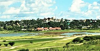
Singida is a city in central Tanzania. The city is the location of the regional headquarters of Singida Region as well as the district headquarters of Singida Urban District. The region and district are named after the city.

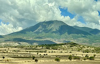
Katesh is a town in northern Tanzania. The town is located in Hanang District, Manyara Region. Paved trunk road T14 from Singida to Babati passes through the town.

Mkalama District is one of the six districts of the Singida Region of Tanzania. It is one of the 20 new districts that were formed in Tanzania since 2010; it was split off from Iramba District. Mkalama District is bordered to the north by Simiyu Region and Arusha Region, to the east by Manyara Region, to the south by Singida Rural District and to the west by Iramba District.

Bahi District is one of the seven districts of the Dodoma Region of Tanzania. Bahi District is bordered to the north by Chemba District, to the east by Dodoma District and Chamwino District, and to the west by Singida Region. Its administrative seat is the town of Bahi.

Chemba District is one of the seven districts of the Dodoma Region of Tanzania. It was formed after 2010, when it was split off from Kondoa District. Chemba District is bordered to the north by Kondoa District, to the east by Manyara Region, to the south by Chamwino District and Bahi District, and to the west by Singida Region. Its administrative seat is the town of Chemba.

Babati Urban District is one of the six districts of the Manyara Region of Tanzania. Babati Urban District is surrounded by Babati Rural District. The administrative capital of the district is Babati town.

