
European route E 14 is a road part of the International E-road network. It begins in Trondheim, Norway and ends in Sundsvall, Sweden. The road is 461 kilometres (286 mi) in length.
The canton of La Ferté-sous-Jouarre is a French administrative division, located in the arrondissement of Meaux, in the Seine-et-Marne département.
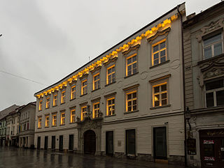
Pálffy Palace is a Baroque-style palace in the Old Town of Bratislava, on Ventúrska street. It was built by Count Leopold Pálffy in 1747. It has an interesting portal with a relief reflecting the military career of the count as a general in the army of Empress Maria Theresa.
Founded in 1977, the English language International School of Aleppo (ISA) was the only International Baccalaureate World School in Syria. It offered the IB Primary Years Programme and IB Diploma Programme. The school's other major programs included International General Certificate of Secondary Education for 9th and 10th graders. As of April 2012, the school is no longer open due to the ongoing Syrian Civil War.
Kelsey is a rural municipality in the province of Manitoba in Western Canada. It consists of several disjoint parts. The largest part is Carrot Valley, located around and southwest of The Pas along the Carrot River, but the communities of Wanless and Cranberry Portage, located further north, are also part of the municipality. It is 867.64 km² large. Also lying in the area around The Pas is the Opaskwayak Cree Nation Indian reserve.

Xırdapay is a village and municipality in the Kurdamir Rayon of Azerbaijan.

Nowa Ruskołęka is a village in the administrative district of Gmina Andrzejewo, within Ostrów Mazowiecka County, Masovian Voivodeship, in east-central Poland. It lies approximately 5 kilometres (3 mi) south-west of Andrzejewo, 17 km (11 mi) east of Ostrów Mazowiecka, and 102 km (63 mi) north-east of Warsaw.
Chisford is an unincorporated community in Westmoreland County, in the U. S. state of Virginia.
Robakowo is a village in the administrative district of Gmina Luzino, within Wejherowo County, Pomeranian Voivodeship, in northern Poland. It lies approximately 3 kilometres (2 mi) east of Luzino, 9 km (6 mi) south-west of Wejherowo, and 39 km (24 mi) north-west of the regional capital Gdańsk.
Linwood is an unincorporated community in Carroll County, Maryland, United States. The community is home to the Linwood Historic District, added to the National Register of Historic Places in 1980.

Đông Viên is a commune (xã) and village in Chợ Đồn District, Bắc Kạn Province, in Vietnam.

Greenwood is an unincorporated community in Glenn County, California. It is located on the Southern Pacific Railroad 3.5 miles (5.6 km) south of Orland, at an elevation of 230 feet.

Wensheng District is a district of the city of Liaoyang, Liaoning province, People's Republic of China.

Dewei, also known as DeAsh, is a town in the Garzê Tibetan Autonomous Prefecture of Sichuan, China which is only accessible through the J1 highway.

Chuansha County (simplified Chinese: 川沙县; traditional Chinese: 川沙縣; pinyin: Chuānshā Xiàn, was a county located in the east of Shanghai until its was fully absorbed by the previously split Pudong New Area in 1993.

Sabine Land is a land area on the east coast of Spitsbergen, Svalbard. It is named after explorer General Sir Edward Sabine. Among the glaciers in the area is the 250-square-kilometer (97 sq mi) Nordmannsfonna glacier.
Städtisches Luisengymnasium München is located in Maxvorstadt, Munich, Bavaria, Germany.

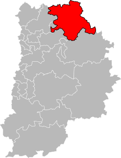
Hasseris is a district of the city of Aalborg and a former municipality in the northeast of Denmark. It is located some 3 km (1.9 mi) southwest of the city centre. As of 2016, Hasseris had 11,685 inhabitants.

Lena Park is an unincorporated community in Wayne Township, Starke County, in the U.S. state of Indiana.
Finleys Mountains is an area in Wayne County in the U.S. state of Missouri. The elevation of the location is 663 feet (202 m). The location is along Greasy Creek about two miles north of Piedmont and US Geological Survey maps show no mountain at the location.


