
Umbria is a region of central Italy. It includes Lake Trasimeno and Marmore Falls, and is crossed by the River Tiber. The regional capital is Perugia. Umbria is known for its landscapes, traditions, history, culinary delights, artistic legacy, and influence on culture.

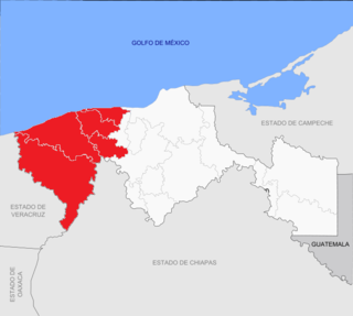
Oaxaca, officially the Free and Sovereign State of Oaxaca, is one of the 31 states which, along with Mexico City, make up the 32 federative entities of Mexico. It is divided into 570 municipalities, of which 418 are governed by the system of usos y costumbres with recognized local forms of self-governance. Its capital city is Oaxaca de Juárez.

The Iguvine Tablets, also known as the Eugubian Tablets or Eugubine Tables, are a series of seven bronze tablets from ancient Iguvium, Italy. The earliest tablets, written in the native Umbrian alphabet, were probably produced in the 3rd century BC, and the latest, written in the Latin alphabet, from the 1st century BC. The tablets contain religious inscriptions that memorialize the acts and rites of the Atiedian Brethren, a group of 12 priests of Jupiter with important municipal functions at Iguvium. The religious structure present in the tablets resembles that of the early stage of Roman religion, reflecting the Roman archaic triad and the group of gods more strictly related to Jupiter. Discovered in a farmer's field in the year 1444, they are currently housed in the Civic Museum of the Palazzo dei Consoli in Gubbio.

Cagayán is a province of the Philippines in the Cagayan Valley region in the northeast of Luzon Island, and includes the Babuyan Islands to the north. The province borders Ilocos Norte and Apayao to the west, and Kalinga and Isabela to the south. Its capital is the city of Tuguegarao.

Jnananjan Niyogi was actively associated with the Indian independence movement and was a social reformer.

San Juan Bautista Tuxtepec, or simply referred to as Tuxtepec, is the head of the municipality by the same name and is the second most populous city of the Mexican state of Oaxaca. It is part of the Tuxtepec District of the Papaloapan Region. As of the 2005 census, the city is home to a population of 94,209 and 144,555 in the municipality, though census data are often under reported for various reasons. The municipality resides in the region called La Cuenca, is located 36 feet above sea level, and occupies an area of approximately 580 square miles (1,500 km2). The city itself is surrounded by the Papaloapan River, and lies a few kilometers south of the Cerro de Oro Dam on its tributary the Santo Domingo River. The municipality is bordered by the state of Veracruz in the north, the municipalities of Loma Bonita to the east and San José Chiltepec to the south. It is almost 100 miles (160 km) to the port of Veracruz, 130 miles (210 km) to Oaxaca City, the state capital, and 310 miles (500 km) to Mexico City.
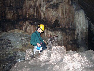
Cave research, encompassing the study of speleology and biospeleology, is still in its infancy in India. Although there are thousands of caves in India, research expeditions occur in few states. The Siju Cave of state Meghalaya is the first limelighted natural cave from India. Several studies were carried out in this cave in the early 20th century. The Kotumsar Cave of Central India is one of the most explored caves of India, and biologists have classified many types of cavernicoles, i.e. trogloxenes, troglophiles and troglobites, from this cave.

Cunduacán is a municipality in the central portion of the state of Tabasco, in Mexico. It is located at about 18°4'0"North, 93°10'0"West.

The Lagunas de Chacahua National Park, created in 1937, is a national park located in the Municipality of Villa de Tututepec de Melchor Ocampo in the Mexican state of Oaxaca, about 54 km west of Puerto Escondido, near a village called Zapotalito. It can be reached via Federal Highway 200 or by boat from Puerto Escondido. The park encompasses 132.73 square kilometres, about 30 km² of which is taken by various lagoons such as the ‘’’Laguna de Chacahua,’’’ ‘’’Laguna de La Pastoria,’’’ and Laguna Las Salinas. There are various smaller lagoons that are connected by narrow channels. The rest of the park consists of dry land.
Costa Grande of Guerrero is a sociopolitical region located in the Mexican state of Guerrero, along the Pacific Coast. It makes up 325 km (202 mi) of Guerrero’s approximately 500 km (311 mi) coastline, extending from the Michoacán border to the Acapulco area, wedged between the Sierra Madre del Sur and the Pacific Ocean. Acapulco is often considered part of the Costa Grande; however, the government of the state classifies the area around the city as a separate region. The Costa Grande roughly correlates to the Cihuatlán province of the Aztec Empire, which was conquered between 1497 and 1504. Before then, much of the area belonged to a dominion under the control of the Cuitlatecs, but efforts by both the Purépecha Empire and Aztec Empire to expand into this area in the 15th century brought this to an end. Before the colonial period, the area had always been sparsely populated with widely dispersed settlements. The arrival of the Aztecs caused many to flee and the later arrival of the Spanish had the same effect. For this reason, there are few archeological remains; however, recent work especially at La Soledad de Maciel has indicated that the cultures here are more important than previously thought. Today, the area economically is heavily dependent on agriculture, livestock, fishing and forestry, with only Zihuatanejo and Ixtapa with significantly developed infrastructure for tourism. The rest of the coast has been developed spottily, despite some government efforts to promote the area.

Petatlán Municipality is one of the 81 municipalities of Guerrero, in south-western Mexico. The municipal seat lies at Petatlán. The municipality covers an area of 2,071.7 km².
Tular is a village in the Sendurai taluk of Ariyalur district, Tamil Nadu, India.
Chontalpa is an area in the Mexican state of Tabasco, which consists of four municipalities in the northwest of the state. Although the name refers to the state’s Chontal Maya population, modern Chontalpa is a subregion of the Grijalva Region, and formed with economic concerns in mind. A large percentage of the state’s Chontal Maya population does live here, with the municipality of Nacajuca having the largest concentration of indigenous, with the next largest concentration found just east of the region in the Villahermosa area. The subregion’s economy is based on agriculture, especially livestock production as well as oil drilling, which have been at odds with each other because of severe degradation of the environment since the mid 20th century. Chontalpa is also home to Tabasco’s two main archeological sites, La Venta and Comalcalco, along with numerous smaller sites.

Stražišče is a former settlement in the Municipality of Kranj in the Upper Carniola region of Slovenia. It is now part of the city of Kranj. It includes the hamlet of Gaštej.

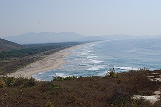
Ría Lagartos Biosphere Reserve is a UNESCO Biosphere Reserve in the state of Yucatán, Mexico. The reserve is located at the eastern end of the coastal strip of the Yucatán Peninsula, with the Gulf of Mexico at its northern limit. The area encompasses coastal areas of the Gulf of Mexico and includes important wetlands designated under the Ramsar Wetlands Convention. The site presents a rich diversity of landscapes and ecosystems, such as mangroves, small estuaries, medium semi-evergreen forest, low deciduous forest, coastal dune vegetation, coastal lagoons, marshes (petenes) and savanna represented by tular vegetation, grasslands and reed beds that are the main nesting sites for marshland and sea birds.


