This article needs additional citations for verification . (August 2012) (Learn how and when to remove this template message) |
Hara | |
---|---|
Village | |
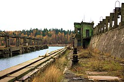
Former Soviet submarine degaussing station in Hara. | |
Country | |
County | Harju County |
Parish | Kuusalu Parish |
Time zone | EET (UTC+2) |
• Summer (DST) | EEST (UTC+3) |
Hara is a village in Kuusalu Parish, Harju County in northern Estonia, on the territory of Lahemaa National Park. It is located on the Juminda Peninsula.
Kuusalu Parish is a rural municipality in northern Estonia, the largest in Harju County. After joining with the adjacent Loksa Parish in 2005, the municipality has now a population of 6,863 and covers an area of 707.97 km². The population density is 9.7 inhabitants per km².
Harju County, or Harjumaa is one of the fifteen counties of Estonia. It is situated in Northern Estonia, on the southern coast of the Gulf of Finland, and borders Lääne-Viru County to the east, Järva County to the southeast, Rapla County to the south, and Lääne County to the southwest. The capital and largest city of Estonia, Tallinn, is situated in Harju County.
Estonia, officially the Republic of Estonia, is a country in Northern Europe. It is bordered to the north by the Gulf of Finland with Finland on the other side, to the west by the Baltic Sea with Sweden on the other side, to the south by Latvia (343 km), and to the east by Lake Peipus and Russia (338.6 km). The territory of Estonia consists of a mainland and 2,222 islands in the Baltic Sea, covering a total area of 45,227 km2 (17,462 sq mi), water 2,839 km2 (1,096 sq mi), land area 42,388 km2 (16,366 sq mi), and is influenced by a humid continental climate. The official language of the country, Estonian, is the second most spoken Finnic language.
A former Soviet submarine station is located in Hara. [1] [2]
Kopački Rit, is a nature park in eastern Croatia in the municipalities of Bilje and Kneževi Vinogradi. It is located northwest of the confluence of the Drava and the Danube, situated at the border with Serbia. It comprises many backwaters and ponds along the Danube. It is one of the most important, largest and most attractive preserved intact wetlands in Europe.
Tsushima Maru (対馬丸) was a Japanese passenger/cargo ship that was sunk by the submarine USS Bowfin during World War II, while carrying hundreds of schoolchildren from Okinawa to Kagoshima.
The Overloon War Museum is located in Overloon, Netherlands.
Dongdaemun Station is a station on the Seoul Subway Line 1 and Line 4. It is named after one of the four great gates of the circular wall surrounding ancient Seoul, and is situated on the eastern end of Jongno. This station is also close to Dongdaemun Market.
German submarine U-479 was a Type VIIC U-boat built for Nazi Germany's Kriegsmarine for service during World War II. She was laid down at the Deutsche Werke in Kiel on 19 November 1942 as yard number 310, launched on 14 August 1943 and was commissioned on 27 October 1943 with Oberleutnant zur See Hans-Joachim Förster, a Knights Cross winner, in command. He was replaced shortly afterwards by Oberleutnant Friedrich-Wilhelm Sons.
The Embassy of the Republic of Mali in Moscow is the diplomatic mission of Mali in the Russian Federation and accredited to several countries of the former CIS. It is located at 11 Novokuznetskaya Street in the Zamoskvorechye District of Moscow.
Hara Station is an underground metro station located in Tempaku-ku, Nagoya, Aichi Prefecture, Japan operated by the Nagoya Municipal Subway's Tsurumai Line. It is located 18.4 rail kilometers from the terminus of the Tsurumai Line at Kami-Otai Station.
Sudiți is a commune located in Ialomița County, Romania. It is composed of two villages, Gura Văii and Sudiți.
The Loobu is a river in Northern Estonia. Its source is about 12 km southwest from Rakvere in Lääne-Viru County and it drains into Eru Bay near the village of Vihasoo in Lahemaa National Park.
Gayaza–Ziroobwe Road is a road in central Uganda, connecting the towns of Gayaza in Wakiso District and Ziroobwe in Luweero District.
Jinhua railway station, formerly Jinhua West railway station, is a railway station on the Shanghai-Kunming railway and the Hangchangkun Passenger Railway located in Zhejiang, People's Republic of China.
Sinyi Elementary School is a station on the Orange line of Kaohsiung MRT in Sinsing District, Kaohsiung, Taiwan.
Pine Hills is an unincorporated community in San Diego County, California, about a mile south and slightly west of Julian. It is located along and at the southern end of Pine Hills Road, about two miles south of state Highway 78. The residents of Pine Hills have an address in Julian in the 92036 zip code.
Uzerche is a railway station in Uzerche, Nouvelle-Aquitaine, France. The station is located on the Orléans–Montauban railway line. The station is served by TGV, Intercités and TER (local) services.
Allu is an island belonging to the country of Estonia.
Günəşli is a village in the Jalilabad Rayon of Azerbaijan.
Geijersgården is located in Uppsala, Sweden, north of Carolina Rediviva, the main building of Uppsala University Library.
German submarine U-679 was a Type VIIC U-boat built for Nazi Germany's Kriegsmarine for service during World War II. She was laid down on 3 September 1942 by Howaldtswerke-Deutsche Werft, Hamburg as yard number 828, launched on 18 September 1943 and commissioned on 29 November 1943 under Oberleutnant zur See Friedrich Breckwoldt.
German submarine U-676 was a Type VIIC U-boat of Nazi Germany's Kriegsmarine during World War II. The submarine was laid down on 13 June 1942 at the Howaldtswerke yard at Hamburg, launched on 6 July 1943, and commissioned on 4 August 1943 under the command of Oberleutnant zur See Werner Sass.
Green Meadows is an unincorporated community in Moral Township, Shelby County, in the U.S. state of Indiana.
Coordinates: 59°34′14″N25°37′51″E / 59.57056°N 25.63083°E
A geographic coordinate system is a coordinate system that enables every location on Earth to be specified by a set of numbers, letters or symbols. The coordinates are often chosen such that one of the numbers represents a vertical position and two or three of the numbers represent a horizontal position; alternatively, a geographic position may be expressed in a combined three-dimensional Cartesian vector. A common choice of coordinates is latitude, longitude and elevation. To specify a location on a plane requires a map projection.
This Harju County location article is a stub. You can help Wikipedia by expanding it. |