
The Swanson River is a stream, 40 miles (64 km) long, on the Kenai Peninsula of south-central Alaska in the United States. Beginning at Gene Lake in the Swanson Lakes district, it flows southwest then north to Number Three Bay on the Gompertz Channel of Cook Inlet.

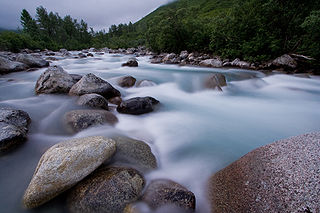
The Kasilof River or Ggasilatnu in the Dena'ina language is a river on the western Kenai Peninsula in southern Alaska. The name is an anglicization of Reka Kasilova, the name given to the river by early Russian settlers in the area. It begins at Tustumena Lake and flows northwest to Cook Inlet near Kasilof. The upper section of the river is very swift, with several sections considered Class II whitewater, and underwater hazards are difficult to detect, due to the silty nature of the glacial runoff that comprises most of the river. The entire river has powerful currents and is very cold. There is public access to the lower section from the Sterling Highway. Drift and bank fishing for salmon is popular on the lower Kasilof.

Wood-Tikchik State Park is a state park in the U.S. state of Alaska north of Dillingham. Over 1,600,000 acres (650,000 ha) (6,500 km2) in area—about the size of the state of Delaware—, comprising more than half of all state park land in Alaska and 15% of the total state park land in the country. Despite being the largest state park in the nation, the park had no staff whatsover for its first five years, and even now at times only a single ranger is in charge of patrolling the entire park, usually by aircraft.

Chugach State Park covers 495,204 acres immediately east of the Anchorage Bowl in south-central Alaska. Though primarily in the Municipality of Anchorage, a small portion of the park north of the Eklutna Lake area in the vicinity of Pioneer Peak lies within the Matanuska-Susitna Borough. Established by legislation signed into law on August 6, 1970, by Alaska Governor Keith Miller, this state park was created to provide recreational opportunities, protect the scenic value of the Chugach Mountains and other geographic features, and ensure the safety of the water supply for Anchorage. The park, managed by Alaska State Parks, is the third-largest state park in the United States, and consists of geographically disparate areas each with different attractions and facilities. Only Anza-Borrego Desert State Park in California and Wood-Tikchik State Park in western Alaska are larger. Hunting and fishing are permitted in the Chugach under regulations established by the Alaska Department of Fish and Game for game management unit 14c. Target practice is not allowed within the park boundaries.
The Chilkoot Lake, in the Tlingit Indians region of Alaska, is also spelt Chilcoot Lake. Its other local names are the Akha Lake and Tschilkut S(ee), meaning "Chilkoot Lake". It is in Haines Borough, Alaska. Chilkoot also means "big fish". The lake has a ‘Recreation Site’ at its southern end near the outlet to the Chilkoot River, which is set amidst the Sitka spruce trees. Chilkoot River flows from the lake for a short length and debouches into the Lutak Channel at the head of the Chilkoot inlet near Haines. Chilkoot village, a settlement of Chilkoot Indians existed at the outlet of the lake, which was called Tschilkut or Tananel or Chilcoot; the lake is named after this village. This village is now a camping area developed by the State Parks and Outdoor Recreation Division of the Alaska Department of Natural Resources. The lake is a popular location for Kayaking.
Little Susitna River heads at Mint Glacier on Montana Peak, in Talkeetna Mountains at 61°51′30″N149°03′30″W, flows southwest to Cook Inlet, 13 miles (21 km) west of Anchorage, Alaska Cook Inlet Low.
The wildlife of Alaska is diverse and abundant.
In Anchorage, Alaska, Sand Lake is the area surrounding Sand Lake, a stocked lake in the southwest part of the city. It is south of the Ted Stevens International Airport and Lake Spenard. The lake itself has a surface area of 78 acres (320,000 m2). It is one of the few big-city lakes in the world with common and Pacific loon populations. Its shores are mostly privately owned, but a small park to the northeast allows public access. Kayakers, fishermen, picnickers and birdwatchers frequent the area.

Lake Hudson State Recreation Area is a public recreation area located within southwestern Lenawee County in the U.S. state of Michigan. It is mostly located within Hudson Township with a very small portion extending south into neighboring Medina Township.
The Chatanika River is a 128-mile (206 km) tributary of the Tolovana River in the U.S. state of Alaska. The Chatanika River is a clear or lightly tannic stained rapid-runoff stream that has its headwaters in the mountains of the northeastern portion of the Alaska Range and flows westward through valleys between summits and uplands for about four-fifths of its length before it enters Minto Flats. Once in the flats—a marshy area in which multiple streams, rivers, and lakes are located— the Chatanika joins the Tolovana, which flows into the Tanana River and on to the Yukon River. The Chatanika is thus a portion of the Yukon River drainage basin.

The following outline is provided as an overview of and topical guide to the U.S. state of Alaska:

The Tangle Lakes are a 16-mile (26 km) long chain of lakes connected by streams in interior Alaska. They form the headwaters for the Delta River.
The Eagle River is a stream, 8 miles (13 km) long, in the borough of Wrangell in the U.S. state of Alaska. Heading at Eagle Lake in the Coast Mountains, it flows northwest through part of the Tongass National Forest into Eagle Bay on the Bradfield Canal. Near the midpoint of its course, the river passes through Little Eagle Lake. On the shore opposite Eagle Bay and the Eagle River mouth, the Harding River enters Bradfield Canal.

Captain Cook State Recreation Area is a park on the Kenai Peninsula in Alaska. It is located on the shores of Cook Inlet at the northern terminus of the Kenai Spur Highway, about 25 miles (40 km) north of Kenai and 14 miles (23 km) north of Nikiski. Both the Inlet and the recreation area are named after Captain James Cook who explored the area in 1778.

Stormy Lake is a lake on the Kenai Peninsula of Alaska, also known as Three Bay Lake. It is located 27 miles (43 km) north of the town of Kenai. The lake has been the target of two efforts to eradicate invasive species and re-introduce native flora and fish.
Birch Lake is a lake in Fairbanks North Star Borough, Alaska. The lake contains Arctic char, Arctic grayling, Chinook salmon, coho salmon, and rainbow trout and has been stocked extensively since 1966. It is a popular spot for both fishing from boats and ice fishing in the winter.
Finger Lake is a lake in Wasilla, Alaska. It is not technically a finger lake, but was named so by Captain Edward Glenn, who led an army expedition to Alaska in 1898 and felt that "when viewing the lake on a map, a point of land in the lake gives the impression of a finger." The lake has populations of Rainbow Trout, Arctic Char and Arctic Grayling and is a popular fishing spot, including ice fishing in winter. The lake is at the south end of the Seven-mile canoe trail that ends at Wasilla Lake, the only portage is at the north end of Finger Lake.

Fielding Lake is an Alaskan lake adjacent to the Richardson Highway, two miles (3.2 km) north of Isabel Pass in the Alaska Range. As an alpine lake, it freezes early in autumn, and ice can remain on portions of the lake as late as July. The lake has good fishing for grayling, burbot and trout, all of which are native populations and not stocked. The lake bottom is mud and gravel, with heavy vegetation in shallow areas. The area around the lake is described as "barren, rolling tundra". The entirety of the lake itself is public, but some areas of the shore are private property.

Nancy Lake State Recreation Area is a 22,685 acres (9,180 ha) park near Willow in the Matanuska-Susitna Borough of Alaska. Founded on July 6, 1966 and set aside specifically for recreational use, the park is home to more than a hundred lakes as well as extensive wetlands. The landscape of the park was crafted in glacial retreats around 9,000 years ago, and around this same time the first inhabitants likely moved into the area. They were eventually followed by Russian exploration, and later increases in white settlement due to commerce and the presence of gold.


