
Harney County is one of the 36 counties in the U.S. state of Oregon. As of the 2020 census, the population was 7,495, making it the sixth-least populous county in Oregon. The county seat is Burns. Established in 1889, the county is named in honor of William S. Harney, a military officer of the period, who was involved in the Pig War and popular in the Pacific Northwest.

The Second Seminole War, also known as the Florida War, was a conflict from 1835 to 1842 in Florida between the United States and groups collectively known as Seminoles, consisting of Native Americans and Black Indians. It was part of a series of conflicts called the Seminole Wars. The Second Seminole War, often referred to as the Seminole War, is regarded as "the longest and most costly of the Indian conflicts of the United States".

Key Biscayne is an island located in Miami-Dade County, Florida, located between the Atlantic Ocean and Biscayne Bay. It is the southernmost of the barrier islands along the Atlantic coast of Florida, and lies south of Miami Beach and southeast of Miami. The key is connected to Miami via the Rickenbacker Causeway, originally built in 1947.

Black Elk Peak is the highest natural point in the U.S. state of South Dakota and the Midwestern United States. It lies in the Black Elk Wilderness area, in southern Pennington County, in the Black Hills National Forest. The peak lies 3.7 mi (6.0 km) west-southwest of Mount Rushmore. At 7,244 feet (2,208 m), it has been described by the Board on Geographical Names as the highest summit in the United States east of the Rocky Mountains. Though part of the North American Cordillera, it is generally considered to be geologically separate from the Rocky Mountains. Lost Mine peak in the Chisos Mountains of Texas, at an elevation of 7,535 feet, is the easternmost peak within the continental United States above 7,000 feet.
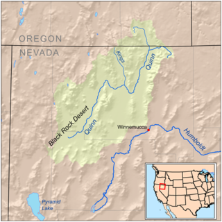
The Kings River is a tributary of the Quinn River, about 40 mi (64 km) long, in northwestern Nevada and south-central Oregon in the United States. It drains a remote arid area of the northwestern Great Basin.

The Harney Basin is an endorheic basin in southeastern Oregon in the United States at the northwestern corner of the Great Basin. One of the least populated areas of the contiguous United States, it is located largely in northern Harney County, bounded on the north and east by the Columbia Plateau—within which it is contained, physiographically speaking—and on the south and west by a volcanic plain. The basin encompasses an area of 1,490 square miles (3,859 km2) in the watershed of Malheur Lake and Harney Lake. Malheur Lake is a freshwater lake, while Harney Lake is saline-alkaline.
Drewsey is an unincorporated community in Harney County, in the U.S. state of Oregon. Drewsey is along the main stem of the Malheur River, about 45 miles (72 km) east of Burns, off U.S. Route 20. It has the ZIP Code of 97904.

Fort Dallas was a military base during the Seminole Wars on the banks of the Miami River in what is now Downtown Miami, Florida, United States.

The Silvies River flows for about 119 miles (192 km) through Grant and Harney counties in the U.S. state of Oregon. The river drains 1,273 square miles (3,300 km2) of the northern Harney Basin.

The Shark River is a major distributary of Harney River in the southwestern portion of Everglades National Park. It is located in Monroe County, Florida, United States. The river is entirely sea level. The mouth of the river is at Ponce de Leon Bay, part of the Gulf of Mexico. The river is only 9.5 miles (15.3 km) long.

Crane is a census-designated place and unincorporated community in Harney County, Oregon, United States, northeast of Malheur Lake on Oregon Route 78. Its population was 129 at the 2010 census.

Harney Lake is a shallow alkali lake basin located in southeast Oregon, United States, approximately 30 miles (48 km) south of the city of Burns. The lake lies within the boundary of the Malheur National Wildlife Refuge and is the lowest point in the Blitzen Valley drainage.

Diamond is an unincorporated community in Harney County, Oregon, United States. Diamond is west of Oregon Route 205 and south of Malheur Lake, 52 miles (84 km) south-southeast of Burns by highway. Its post office is assigned ZIP code 97722.
Lawen is an unincorporated community in Harney County, Oregon, United States. It has a post office with a ZIP code 97720. Lawen lies along Oregon Route 78 just south of its interchanges with Oregon Route 205, U.S. Route 20, and U.S. Route 395 in Burns, the county seat. Lawen is just north of the East Fork Silvies River and Malheur Lake.
Lake Harney, named for General William S. Harney, is a lake that straddles the county line between Volusia County and Seminole County, Florida, at the coordinates latitude 28°45’21.404", longitude 81° 03’36.019". It is fed by the Saint Johns River which flows through central Florida and feeds many of the nearby lakes such as Lake Monroe.

The P Ranch is a historic ranch in Harney County in southeastern Oregon, United States. The remaining ranch structures are located on the west bank of the Donner und Blitzen River in the Malheur National Wildlife Refuge. The ranch was built by Peter French, a well known 19th-century cattle baron. The P Ranch became headquarters for the French-Glenn Livestock Company, which eventually covered over 140,000 acres (570 km2). After French was murdered in 1897, the French-Glenn Livestock Company slowly sold off the P Ranch property. In 1935, the United States Government purchased the remaining P Ranch property to add to an adjacent wildlife refuge. The Civilian Conservation Corps demolished most of the original ranch buildings in the 1930s, and a fire destroyed the main ranch house in 1947. The few remaining P Ranch structures are now listed on the National Register of Historic Places.
Pennichaw is a rural unincorporated community located in south Volusia County, Florida, United States. It located on Lake Harney Road, approximately 1.8 miles south of Maytown Road.
Voltage is an unincorporated community in Harney County, Oregon, United States. It is about 34 miles (55 km) south of Burns, on the south shore of Malheur Lake near the Donner und Blitzen River.
Suntex is the name of an unincorporated community in Harney County, in the U.S. state of Oregon. It was established with the placement of a post office in the valley of Silver Creek west of Burns and north of U.S. Route 20.
Harney is an unincorporated community in Harney County, in the U.S. state of Oregon. It lies north of U.S. Route 20 between Burns and Buchanan near the site of historic Fort Harney. The community, county, and nearby geographic features such as Harney Lake are named for William S. Harney, a military officer popular in the Pacific Northwest in the mid-19th century.
