
Cranham is a residential area of east London, and part of the London Borough of Havering. It is located 17.5 miles (28 km) east-northeast of Charing Cross and comprises an extensive built-up area to the north and a low density conservation area to the south surrounded by open land. It was historically a rural village in the county of Essex and formed an ancient parish. It is peripheral to London, forming the eastern edge of the urban sprawl. The economic history of Cranham is characterised by a shift from agriculture to housing development. As part of the suburban growth of London in the 20th century, Cranham significantly increased in population, becoming part of Hornchurch Urban District in 1934 and has formed part of Greater London since 1965. The 2011 Census population of Cranham was included in Upminster.
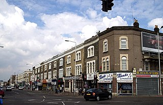
Goodmayes is an area in Ilford, in East London, England. It is a ward of the London Borough of Redbridge, eleven miles north-east of Charing Cross, and forms part of both the Romford and Ilford post towns. Historically part of Essex, it was part of the Municipal Borough of Ilford until 1965 when it was incorporated into Greater London.

Harold Wood is a suburban neighbourhood in East London in the London Borough of Havering. It is situated 16.5 miles (26.6 km) east-northeast of Charing Cross. Harold Wood was part of the ancient parish of Hornchurch, which became the Liberty of Havering. Most of the current area of Harold Wood became part of Hornchurch Urban District in 1926. It is near to the Greater London boundary with Essex.

Hornchurch is a suburban town in East London in the London Borough of Havering. It is located 15.2 miles (24.5 km) east-northeast of Charing Cross. It comprises a number of shopping streets and a large residential area. It historically formed a large ancient parish in the county of Essex that became the manor and liberty of Havering. The economic history of Hornchurch is underpinned by a shift away from agriculture to other industries with the growing significance of nearby Romford as a market town and centre of administration. As part of the suburban growth of London in the 20th century, Hornchurch significantly expanded and increased in population, becoming an urban district in 1926 and has formed part of Greater London since 1965. It is the location of Queen's Theatre, Havering Sixth Form College and Havering College of Further and Higher Education.

Romford is a large town in East London, England, 14 miles (23 km) northeast of Charing Cross. Part of the London Borough of Havering, the town is one of the major metropolitan centres of Greater London identified in the London Plan.

The London Borough of Havering in East London, England, forms part of Outer London. It has a population of 259,552 inhabitants; the principal town is Romford, while other communities include Hornchurch, Upminster, Collier Row and Rainham. The borough is mainly suburban, with large areas of protected open space. Romford is a major retail and night time entertainment centre, and to the south the borough extends into the London Riverside redevelopment area of the Thames Gateway. The name Havering is a reference to the Royal Liberty of Havering which occupied the area for several centuries. The local authority is Havering London Borough Council. It is the easternmost London borough.

Harold Hill is a suburban area in the London Borough of Havering, East London. 16.6 miles (26.7 km) northeast of Charing Cross. It is a district centre in the London Plan. The name refers to King Harold II, who held the manor of Havering-atte-Bower, and who was killed at the Battle of Hastings in 1066. The suburb is peripheral to London, forming an eastern edge of the urban sprawl.

Barts Health NHS Trust is an NHS trust based in London, England. Established in 2012, it runs five hospitals throughout the City of London and East London, and is one of the largest NHS trusts in England.

Hornchurch was a borough constituency represented in the House of Commons of the Parliament of the United Kingdom. It elected one Member of Parliament (MP) by the first past the post system of election. At the 2010 general election parts formed the new seats of Hornchurch and Upminster; and Dagenham and Rainham.

Hornchurch was a local government district in southwest Essex from 1926 to 1965, formed as an urban district for the civil parish of Hornchurch. It was greatly expanded in 1934 with the addition of Cranham, Great Warley, Rainham, Upminster and Wennington; and in 1936 by gaining North Ockendon. Hornchurch Urban District Council was based at Langtons House in Hornchurch from 1929. The district formed a suburb of London and with a population peaking at 131,014 in 1961, it was one of the largest districts of its type in England. It now forms the greater part of the London Borough of Havering in Greater London.
South Hornchurch is a locality to the south of Hornchurch in London Borough of Havering, east London. It is a suburban development situated 13.6 miles (21.8 km) east of Charing Cross. The area is a relatively recent addition, compared with the more mature suburbs in Havering. It was built on open farmland and the former site of RAF Hornchurch.

Newham University Hospital is an acute general hospital situated in Plaistow in the London Borough of Newham. It is managed by Barts Health NHS Trust.

King George Hospital is an NHS hospital located on Barley Lane in the Goodmayes area of Ilford, in the London Borough of Redbridge. The hospital is part of Barking, Havering and Redbridge University Hospitals NHS Trust.

Oldchurch Hospital was a hospital in Greater London, United Kingdom, located in Romford in the London Borough of Havering and part of the Barking, Havering and Redbridge Hospitals NHS Trust.

Queen's Hospital is a large teaching hospital in Romford in the London Borough of Havering. It was built on the site of the former Oldchurch Park, a short distance south of the town centre. It was opened in 2006 and serves a population of about 800,000 people. It is run by Barking, Havering and Redbridge University Hospitals NHS Trust.
Barking, Havering and Redbridge University Hospitals NHS Trust is an NHS trust which runs King George Hospital in Goodmayes and Queen's Hospital in Romford. It also operates clinics at a number of sites in the nearby area including Barking Hospital and Brentwood Community Hospital.

Mile End Hospital is a community hospital in the Mile End area of the London Borough of Tower Hamlets in England. It is managed by Barts Health NHS Trust.
Public transport in the London Borough of Havering, in east London, England, is a mix of National Rail, London Underground, London Overground and Elizabeth line and London Buses services. Rail services are primarily radial to central London with bus services providing most of the orbital connections. The public transport authority is Transport for London and the local authority is Havering London Borough Council.

St George's Hospital was a hospital on Suttons Lane in Hornchurch in the London Borough of Havering, in northeast London, England. It opened in 1938 and closed in October 2012.
North East London NHS Foundation Trust (NELFT) is an NHS foundation trust which provides mental and community health services. It runs Foxglove Ward, Goodmayes Hospital and Sunflowers Court in Ilford, Phoenix House in Basildon, Heronwood & Galleon Inpatient Facility in Wanstead, Grays Court Community Hospital in Dagenham, and Hawkwell Court in Chingford. Altogether it operates from more than 150 sites.

