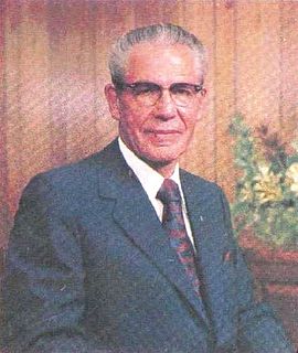
Nathan Eldon Tanner was a politician from Alberta, Canada, and a leader of The Church of Jesus Christ of Latter-day Saints. He served in the Legislative Assembly of Alberta from 1935 to 1952 as a member of the Social Credit caucus in government. He served as Speaker of the Legislative Assembly from 1936 to 1937 and as a cabinet minister in the governments of William Aberhart and Ernest Manning from 1937 to 1952, in various portfolios related to resource industries.

Raymond is a town in the County of Warner No. 5, Alberta, Canada. It is located in southern Alberta south of Lethbridge on Highway 52. Raymond is known for its annual rodeo and the large population of members of The Church of Jesus Christ of Latter-Day Saints. The sole high school in the town, Raymond High School, is known for its sports achievements in basketball, Canadian football, and women's rugby.

The Cardston Alberta Temple is the eighth constructed and sixth of the still-operating temples of The Church of Jesus Christ of Latter-day Saints. Located in Cardston, Alberta, it is the oldest LDS temple outside the United States. It is one of eight temples that do not have an angel Moroni statue, and one of three without spires, similar to Solomon's Temple. The other two are the Laie Hawaii and Mesa Arizona temples. It is also one of only two LDS temples built in the shape of a cross, the other being the Laie temple.
Edgar Wynder "Ted" Hinman was a provincial politician from Alberta, Canada. He served as member of the Legislative Assembly of Alberta from 1952 to 1967 and again from 1971 to 1975, sitting with the Social Credit caucus in both government and opposition. During his time in office he served in the cabinet of Premier Ernest Manning from 1954 to 1964.
Broyce G. Jacobs is a Canadian politician and was a Member of the Legislative Assembly of Alberta representing the constituency of Cardston-Taber-Warner as a Progressive Conservative.

Austin Albert Mardon, Ph.D. is an author, community leader, and advocate for the disabled. He is an assistant adjunct professor at the John Dossetor Health Ethics Centre at the University of Alberta. In the mid 80's, he founded and today still directs the Antarctic Institute of Canada, a non-profit entity based in Edmonton, Alberta. He is currently married to lawyer and activist Catherine Mardon, and has co-written several books with her.

Chesham is an unincorporated community within the town of Harrisville in Cheshire County, New Hampshire, United States. Part of the village is listed on the National Register of Historic Places as the Chesham Village District, while the southernmost portions are included in the Pottersville District, also listed on the National Register.

Provincial historic sites of Alberta are museums and historic sites run by the Government of Alberta.

Woolford is a hamlet in southern Alberta, Canada within Cardston County. It is located on Highway 503, approximately 16 kilometres (9.9 mi) southeast of Cardston between the St. Mary River and the Milk River Ridge. It is named after Thomas Woolford who came to the area in 1900.

Mountain View is a hamlet in Alberta, Canada within Cardston County. It is located along Highway 5 approximately 25 kilometres (16 mi) west of Cardston and 20 kilometres (12 mi) east of Waterton Lakes National Park near the United States border. It is also a kickoff point for visitors to Police Outpost Provincial Park, 18 kilometers to the south.

Kimball is a hamlet in southern Alberta, Canada within Cardston County. It is located on Highway 501, approximately 16 kilometres (9.9 mi) southeast of Cardston between the St. Mary River and the Milk River Ridge. The community is named after the Mormon ward which was named after the descendents of Heber C Kimball.

Taylorville is an unincorporated community in Cardston County, Alberta, Canada. It is located on Highway 501 ten miles southeast of Cardston. The first school opened May 17, 1900 and then later served as a chapel for The Church of Jesus Christ of Latter-day Saints.

Raley, Alberta is an unincorporated community in Cardston County, Alberta, Canada. The population of Raley was 5 in 1966. The community is located about 4 km north of Highway 3, and about 15 km east of the Town of Cardston. Raley is named after C. Raley, of Lethbridge.
Leavitt is a hamlet in southern Alberta, Canada within Cardston County, located about 13 kilometres (8 mi) west of Cardston on Highway 5. It falls within the Canadian federal electoral district of Medicine Hat—Cardston—Warner.

Aetna is a hamlet in southern Alberta, Canada within Cardston County, located 2 kilometres (1.2 mi) east of Highway 2, approximately 70 kilometres (43 mi) southwest of Lethbridge.

Beazer is a hamlet in southern Alberta, Canada within Cardston County, located 6 kilometres (3.7 mi) south of Highway 5, approximately 80 kilometres (50 mi) southwest of Lethbridge. It is named in 1900 after Mark Beazer who organized the first congregation of The Church of Jesus Christ of Latter-day Saints there.
Hyrum Conrad Pope was a German-born architect with important architectural works throughout the western United States and Canada. Pope was born in Fürth, Bavaria and immigrated to the United States as a teenager. He went to school at the Art Institute of Chicago where he was influenced in the Prairie School architectural style. In 1910, he opened an architectural firm with Harold W. Burton in Salt Lake City, Utah. Pope designed a variety of places of worship for many faiths, civic buildings and homes, some of which are listed on the National Register of Historic Places.

Saint Aloysius on the Ohio is a Roman Catholic parish in the Sayler Park neighborhood of Cincinnati, Ohio, United States. The parish is part of the Archdiocese of Cincinnati. It is named after St. Aloysius Gonzaga and located near the Ohio River.


